Skip to content · ⁨ข้ามไปยังเนื้อหา⁩

Earth Systems and Resources · ⁨ระบบของโลกและทรัพยากร⁩

AP Environmental Science · Topic 4 · ⁨หัวข้อ 4⁩

Video lesson for this topic · ⁨บทเรียนวิดีโอสำหรับหัวข้อนี้⁩ Open the video page · ⁨เปิดหน้าวิดีโอ⁩
7:28

ระบบของโลกและทรัพยากร

เมืองสองเมืองห่างกันสี่สิบกิโลเมตร อยู่คนละฟากของเทือกเขาเมืองหนึ่งมีฝนตกสามเมตรต่อปี — เป็นป่าฝน เมืองอีกแห่งมีฝนน้อยกว่า…

English narration · English + 中文 subtitles burned in · ⁨การบรรยายภาษาอังกฤษ · คำบรรยายภาษาอังกฤษ + 中文 ลอยตัวบนภาพ⁩

4.1

Plate Tectonics · ⁨ทฤษฎีแผ่นเปลือกโลก⁩

Syllabus · ⁨หลักสูตร⁩
English

Enduring Understanding (ERT-4): Earth's systems interact, resulting in a state of balance over time.

Learning Objective ERT-4.A: Describe the geological changes and events that occur at convergent, divergent, and transform plate boundaries.

  • ERT-4.A.1 Convergent boundaries can result in the creation of mountains, island arcs, earthquakes, and volcanoes.
  • ERT-4.A.2 Divergent boundaries can result in seafloor spreading, rift valleys, volcanoes, and earthquakes.
  • ERT-4.A.3 Transform boundaries can result in earthquakes.
  • ERT-4.A.4 Maps that show the global distribution of plate boundaries can be used to determine the location of volcanoes, island arcs, earthquakes, hot spots, and faults.
  • ERT-4.A.5 An earthquake occurs when stress overcomes a locked fault, releasing stored energy.
ไทย

ความเข้าใจที่ยั่งยืน (ERT-4): ระบบของโลกมีปฏิสัมพันธ์กัน ส่งผลให้เกิดสมดุลในช่วงเวลาหนึ่ง

วัตถุประสงค์การเรียนรู้ ERT-4.A: อธิบายการเปลี่ยนแปลงทางธรณีวิทยาและเหตุการณ์ที่เกิดขึ้นที่ขอบเขตแผ่นเปลือกโลกแบบรวมตัว แบบแยกตัว และแบบเคลื่อนที่สัมพัทธ์

  • ERT-4.A.1 ขอบเขตแบบรวมตัวอาจนำไปสู่การสร้างภูเขา弧เกาะแผ่นดินไหวและภูเขาไฟ
  • ERT-4.A.2 ขอบเขตแบบแยกตัวอาจนำไปสู่การขยายตัวของพื้นทะเล หุบเขาrift ภูเขาไฟและแผ่นดินไหว
  • ERT-4.A.3 ขอบเขตแบบเคลื่อนที่สัมพัทธ์อาจนำไปสู่แผ่นดินไหว
  • ERT-4.A.4 แผนที่แสดงการกระจายตัวของขอบเขตแผ่นเปลือกโลกทั่วโลกสามารถใช้ระบุตำแหน่งของภูเขาไฟ弧เกาะแผ่นดินไหวจุดร้อนและรอยร้าว
  • ERT-4.A.5 แผ่นดินไหวเกิดขึ้นเมื่อความเครียดชนะรอยร้าวที่ล็อคอยู่ ปล่อยพลังงานที่สะสมไว้
Source: College Board AP Course and Exam Description · ⁨แหล่งที่มา: คำอธิบายหลักสูตรและข้อสอบ College Board AP⁩

English
The three plate boundaries

Earth's crust is broken into plates 板块 that slowly move on the mantle – plate tectonics 板块构造. At divergent boundaries plates spread apart (new crust); at convergent they collide (mountains, volcanoes, earthquakes); at transform they slide past (earthquakes). Boundaries create hazards but also volcanic soils and mineral resources.

ไทย
ขอบเขตของแผ่นเปลือกโลกทั้งสาม

เปลือกโลกของโลกถูกแบ่งออกเป็น แผ่นเปลือกโลก ที่เคลื่อนที่ช้าๆ บนชั้นแมนเทิล – ซึ่งเรียกว่า ทฤษฎีแผ่นเปลือกโลก ที่ ขอบเขตแยกตัว แผ่นเปลือกโลกจะถ่างออกจากกัน (เกิดเปลือกโลกใหม่); ที่ ขอบเขตรวมตัว จะชนกัน (เกิดภูเขา โวลคาโน สึนามิ); ที่ ขอบเขตเลื่อนผ่าน จะลื่น彼此的ผ่านกัน (เกิดแผ่นดินไหว) ขอบเขตเหล่านี้สร้างภัยคุกคามแต่ยังให้ดินภูเขาไฟและแร่ธาตุที่มีคุณค่าด้วย

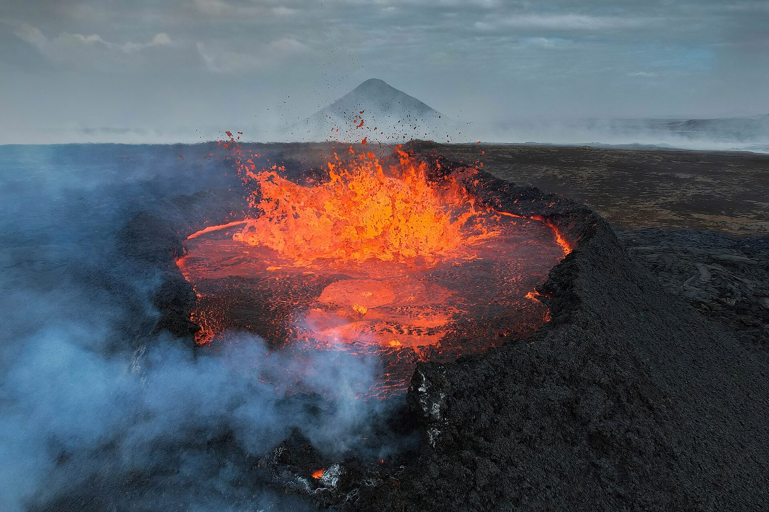
ลาวาสีส้มสดใสพ่นออกมาจากปากภูเขาไฟสีมืดในไอร์แลนด์เหนือ
ภูเขาไฟระเบิดที่ขอบเขตแผ่นเปลือกโลกในไอร์แลนด์เหนือ ลาวาที่พุ่งขึ้นระหว่างแผ่นเปลือกโลกที่กำลังถ่างออก ช่วยสร้างเปลือกโลกใหม่
Vocabulary · ⁨คำศัพท์⁩ Train · ⁨ฝึกฝน⁩
English ไทย
plates/pleɪts/ แผ่นเปลือกโลก
plate tectonics/pleɪt tekˈtɒnɪks/ พลेटเทคโทนิก
4.2

Soil Formation and Erosion · ⁨การก่อตัวของดินและการกัดเซาะ⁩

Syllabus · ⁨หลักสูตร⁩
English

Enduring Understanding (ERT-4): Earth's systems interact, resulting in a state of balance over time.

Learning Objective ERT-4.B: Describe the characteristics and formation of soil.

  • ERT-4.B.1 Soils are formed when parent material is weathered, transported, and deposited.
  • ERT-4.B.2 Soils are generally categorized by horizons based on their composition and organic material.
  • ERT-4.B.3 Soils can be eroded by winds or water. Protecting soils can protect water quality as soils effectively filter and clean water that moves through them.
ไทย

ความเข้าใจที่ยั่งยืน (ERT-4): ระบบของโลกมีปฏิสัมพันธ์กัน ส่งผลให้เกิดสมดุลในช่วงเวลาหนึ่ง

วัตถุประสงค์การเรียนรู้ ERT-4.B: อธิบายลักษณะและการเกิดของดิน

  • ERT-4.B.1 ดินเกิดขึ้นเมื่อวัสดุต้นกำเนิดถูกผุสลายขนย้ายและสะสมตัว
  • ERT-4.B.2 โดยทั่วไปดินจะถูกจัดหมวดหมู่ตามชั้นดินโดยพิจารณาจากองค์ประกอบและสารอินทรีย์
  • ERT-4.B.3 ดินสามารถถูกกัดเซาะโดยลมหรือน้ำ การปกป้องดินสามารถปกป้องคุณภาพน้ำได้เนื่องจากดินทำหน้าที่กรองและทำความสะอาดน้ำที่ไหลผ่านได้อย่างมีประสิทธิภาพ

Source: College Board AP Course and Exam Description · ⁨แหล่งที่มา: คำอธิบายหลักสูตรและข้อสอบ College Board AP⁩

English

Soil 土壤 forms slowly as rock weathers 风化 and organic matter builds up. Erosion 侵蚀 is the removal of soil by wind and water, sped up by removing vegetation (farming, deforestation, overgrazing). Because soil forms so slowly, erosion faster than formation depletes a vital resource.

ไทย

ดิน ก่อตัวขึ้นอย่างช้าๆ เมื่อหิน ผุพัง และสารอินทรีย์สะสมเข้าด้วยกัน การกัดเซาะ คือการกำจัดดินด้วยลมและน้ำ ซึ่งเร่งความเร็วขึ้นจากการทำลายพืชพรรณ (การเกษตร การตัดไม้ทำลายป่า การเลี้ยงสัตว์กินหญ้าเกินขนาด) เนื่องจากดินก่อตัวช้ามาก การกัดเซาะที่เร็วกว่าการก่อตัวจึงทำให้แหล่งทรัพยากรอันมีค่านี้หมดสิ้นไป

ชั้นดินต่างๆ ก่อตัวขึ้นตามเวลาเมื่อหินต้นกำเนิดผุพัง; การกัดเซาะสามารถล้างดินชั้นบนและย้อนกลับความคืบหน้านี้ได้
Vocabulary · ⁨คำศัพท์⁩ Train · ⁨ฝึกฝน⁩
English ไทย
Soil/sɔɪl/ ดิน
weathers/ˈweðəz/ ผุพัง
Erosion/ɪˈrəʊʒn/ การกัดกร่อน
texture/ˈtekstʃə/ พื้นผิว
4.3

Soil Composition and Properties · ⁨องค์ประกอบและคุณสมบัติของดิน⁩

Syllabus · ⁨หลักสูตร⁩
English

Enduring Understanding (ERT-4): Earth's systems interact, resulting in a state of balance over time.

Learning Objective ERT-4.C: Describe similarities and differences between properties of different soil types.

  • ERT-4.C.1 Water holding capacity—the total amount of water soil can hold—varies with different soil types. Water retention contributes to land productivity and fertility of soils.
  • ERT-4.C.2 The particle size and composition of each soil horizon can affect the porosity, permeability, and fertility of the soil.
  • ERT-4.C.3 There are a variety of methods to test the chemical, physical, and biological properties of soil that can aid in a variety of decisions, such as irrigation and fertilizer requirements.
  • ERT-4.C.4 A soil texture triangle is a diagram that allows for the identification and comparison of soil types based on their percentage of clay, silt, and sand.
ไทย

ความเข้าใจที่ยั่งยืน (ERT-4): ระบบของโลกมีปฏิสัมพันธ์กัน ส่งผลให้เกิดสมดุลในช่วงเวลาหนึ่ง

วัตถุประสงค์การเรียนรู้ ERT-4.C: อธิบายความคล้ายคลึงและความแตกต่างระหว่างคุณสมบัติของดินแต่ละประเภท

  • ERT-4.C.1 ความสามารถในการกักเก็บน้ำ – ปริมาณน้ำทั้งหมดที่ดินสามารถกักเก็บได้ – แตกต่างกันไปตามชนิดของดิน ความสามารถในการกักเก็บน้ำช่วยเพิ่มผลผลิตของที่ดินและความอุดมสมบูรณ์ของดิน
  • ERT-4.C.2 ขนาดอนุภาคและองค์ประกอบของแต่ละชั้นดินสามารถส่งผลต่อรูพรุน permeability และความอุดมสมบูรณ์ของดิน
  • ERT-4.C.3 มีวิธีการหลากหลายในการทดสอบคุณสมบัติทางเคมี กายภาพและชีวภาพของดินซึ่งสามารถช่วยให้ตัดสินใจในหลายด้าน เช่น ความต้องการระบบชลประทานและปุ๋ย
  • ERT-4.C.4 สามเหลี่ยมเนื้อดินคือแผนภาพที่ใช้สำหรับระบุและเปรียบเทียบชนิดของดินโดยอาศัยสัดส่วนของดินเหนียว ทรายละเอียดและทรายหยาบ

Source: College Board AP Course and Exam Description · ⁨แหล่งที่มา: คำอธิบายหลักสูตรและข้อสอบ College Board AP⁩

English

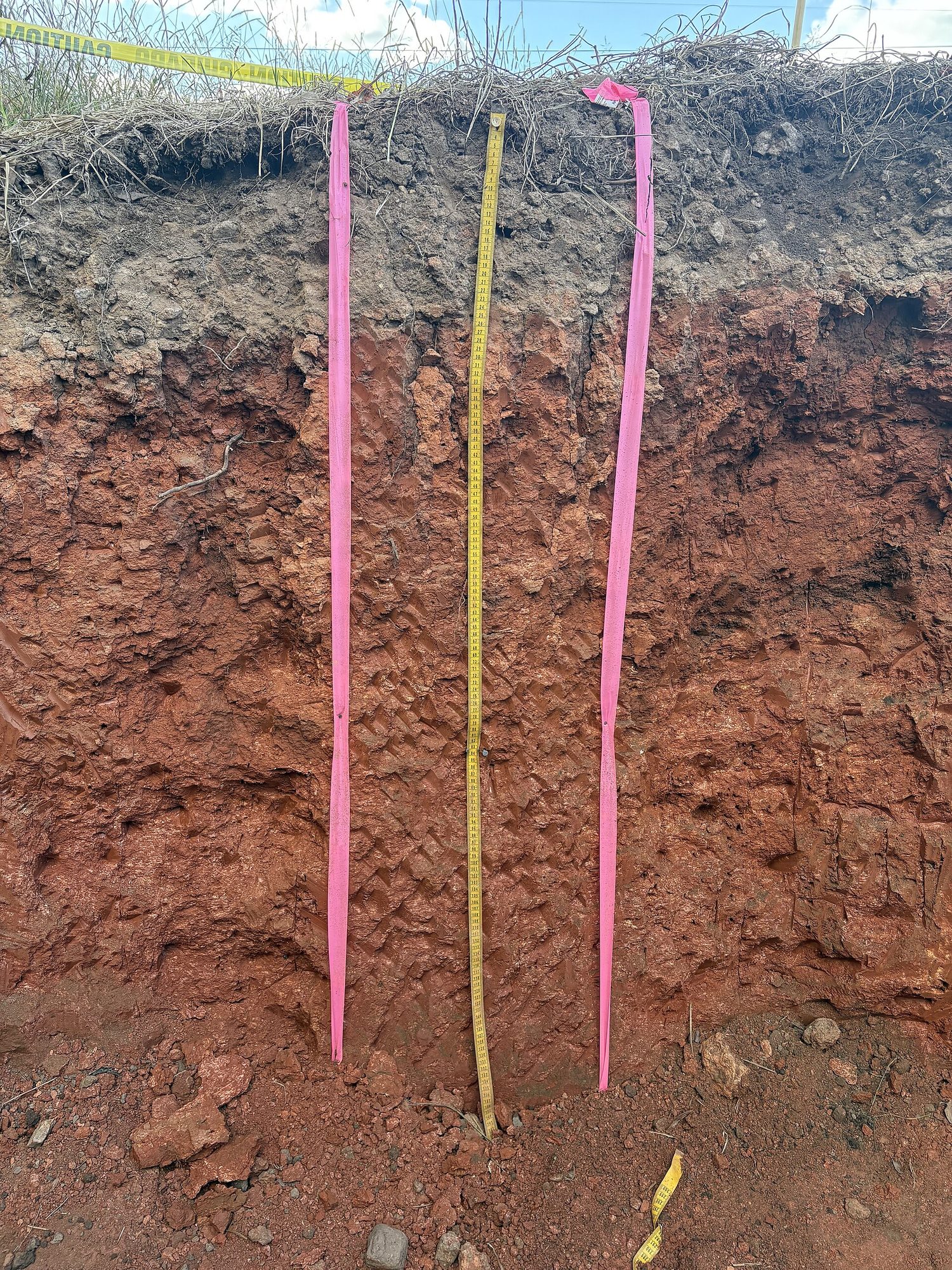
Soil is a mix of sand, silt, and clay (its texture 质地), plus organic matter, water, and air, layered in horizons 土层. Texture controls porosity 孔隙度 and permeability 渗透性 – how well soil holds water and nutrients. Loam (a balanced mix) is best for plants.

ไทย

ดินเป็นส่วนผสมของทราย หินปูน และดินเหนียว (เนื้อสัมผัส) รวมถึงสารอินทรีย์ น้ำ และอากาศ จัดเรียงเป็น ชั้นดิน เนื้อสัมผัสควบคุม ความพรุน และ การซึมผ่าน – ซึ่ง Determines ว่าดินกักเก็บน้ำและสารอาหารได้ดีเพียงใด ดินร่วน (ส่วนผสมที่สมดุล) เหมาะสมที่สุดสำหรับพืช

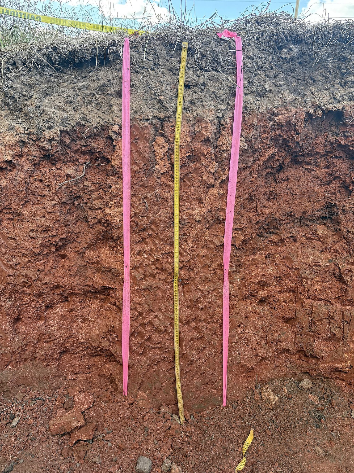
หลุมขุดแนวตั้งผ่านชั้นดิน แสดงแถบดินชั้นบนสีดำเหนือชั้นแร่สีน้ำตาลแดง พร้อมสายวัดเพื่อแสดงสเกล
หลุมขุดผ่านชั้นดินแสดงให้เห็นชั้นต่างๆ ของมัน: ดินชั้นบนอินทรีย์สีดำด้านบน แล้วตามด้วยชั้นแร่สีอ่อนกว่า อยู่เหนือหินแตกหัก (สายวัดเพื่อแสดงสเกล)
Vocabulary · ⁨คำศัพท์⁩ Train · ⁨ฝึกฝน⁩
English ไทย
horizons/həˈraɪznz/ ชั้นดิน
porosity/pɔːˈrɒsɪti/ ความพรุน
permeability/ˌpɜːməˈbɪlɪti/ permeability
atmosphere/ˈætməsfɪə/ ชั้นบรรยากาศ
troposphere/ˈtrɒpəsfɪə/ ชั้นบรรยากาศใกล้พื้นผิว (troposphere)
stratosphere/ˈstrætəsfɪə/ ชั้นสตราโตสเฟียร์
global wind patterns/ˈɡləʊbl wɪnd ˈpætnz/ รูปแบบลมทั่วโลก
convection cells/kənˈvekʃn selz/ เซลล์การพาความร้อน
Coriolis effect/ˌkɒrɪˈəʊliz ɪˈfekt/ ผลโคริอลิส (Coriolis effect)
4.4

Earth's Atmosphere · ⁨บรรยากาศของโลก⁩

Syllabus · ⁨หลักสูตร⁩
English

Enduring Understanding (ERT-4): Earth's systems interact, resulting in a state of balance over time.

Learning Objective ERT-4.D: Describe the structure and composition of the Earth's atmosphere.

  • ERT-4.D.1 The atmosphere is made up of major gases, each with its own relative abundance.
  • ERT-4.D.2 The layers of the atmosphere are based on temperature gradients and include the troposphere, stratosphere, mesosphere, thermosphere, and exosphere.
ไทย

ความเข้าใจที่ยั่งยืน (ERT-4): ระบบของโลกมีปฏิสัมพันธ์กัน ส่งผลให้เกิดสมดุลในช่วงเวลาหนึ่ง

วัตถุประสงค์การเรียนรู้ ERT-4.D: อธิบายโครงสร้างและองค์ประกอบของบรรยากาศของโลก

  • ERT-4.D.1 บรรยากาศประกอบด้วยแก๊สหลักๆ แต่ละชนิดมีปริมาณสัมพัทธ์ของตนเอง
  • ERT-4.D.2 ชั้นของบรรยากาศจัดตาม gradiantอุณหภูมิ ประกอบด้วยชั้น troposphere stratosphere mesosphere thermosphere และ exosphere

Source: College Board AP Course and Exam Description · ⁨แหล่งที่มา: คำอธิบายหลักสูตรและข้อสอบ College Board AP⁩

English

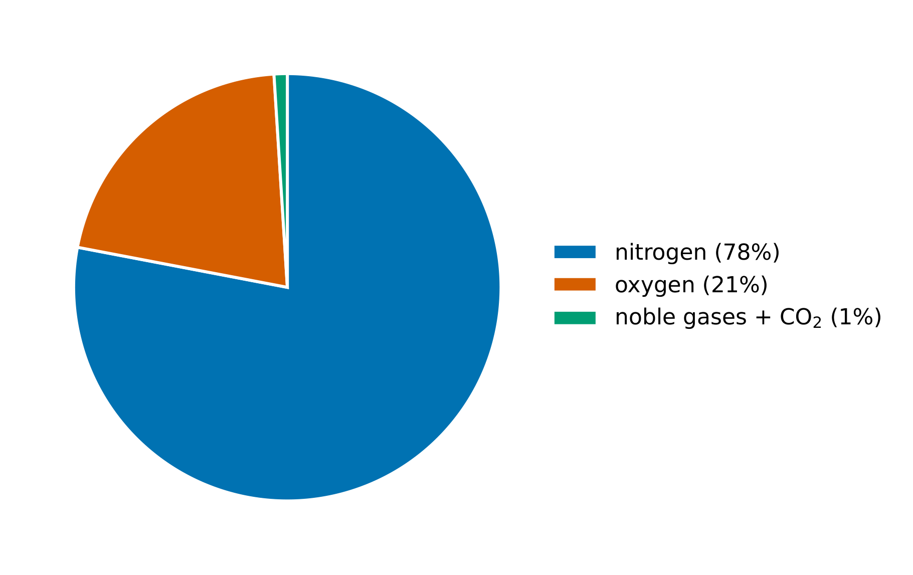
The atmosphere 大气层 is layered: the troposphere 对流层 (weather, where we live), the stratosphere 平流层 (holding the ozone layer), and higher layers. It is mostly nitrogen and oxygen, with trace gases (including greenhouse gases) that regulate temperature.

ไทย

บรรยากาศ แบ่งเป็นชั้น: ชั้นโทรโพสเฟียร์ (สภาพอากาศ ที่เราอาศัยอยู่), ชั้นสตราโทสเฟียร์ (ที่เก็บชั้นโอโซน) และชั้นที่สูงกว่า เป็นส่วนใหญ่ประกอบด้วยไนโตรเจนและออกซิเจน มีก๊าซปริมาณน้อย (รวมถึงก๊าซเรือนกระจก) ที่ช่วยควบคุมอุณหภูมิ

อากาศสะอาดแห้งมีไนโตรเจนประมาณ 78% ออกซิเจน 21% และก๊าซอื่นๆ 1%
4.5

Global Wind Patterns · ⁨รูปแบบลมทั่วโลก⁩

Syllabus · ⁨หลักสูตร⁩
English

Enduring Understanding (ERT-4): Earth's systems interact, resulting in a state of balance over time.

Learning Objective ERT-4.E: Explain how environmental factors can result in atmospheric circulation.

  • ERT-4.E.1 Global wind patterns primarily result from the most intense solar radiation arriving at the equator, resulting in density differences and the Coriolis effect.
ไทย

ความเข้าใจที่ยั่งยืน (ERT-4): ระบบของโลกมีปฏิสัมพันธ์กัน ส่งผลให้เกิดสมดุลในช่วงเวลาหนึ่ง

วัตถุประสงค์การเรียนรู้ ERT-4.E: อธิบายว่าปัจจัยสิ่งแวดล้อมสามารถทำให้เกิดการหมุนเวียนของบรรยากาศได้อย่างไร

  • ERT-4.E.1 ลมระดับโลกเกิดจากการรังสีแดดที่เข้มที่สุดถึง赤道 ทำให้เกิดความแตกต่างของความหนาแน่นและ Coriolis effect

Source: College Board AP Course and Exam Description · ⁨แหล่งที่มา: คำอธิบายหลักสูตรและข้อสอบ College Board AP⁩

English
Global wind patterns

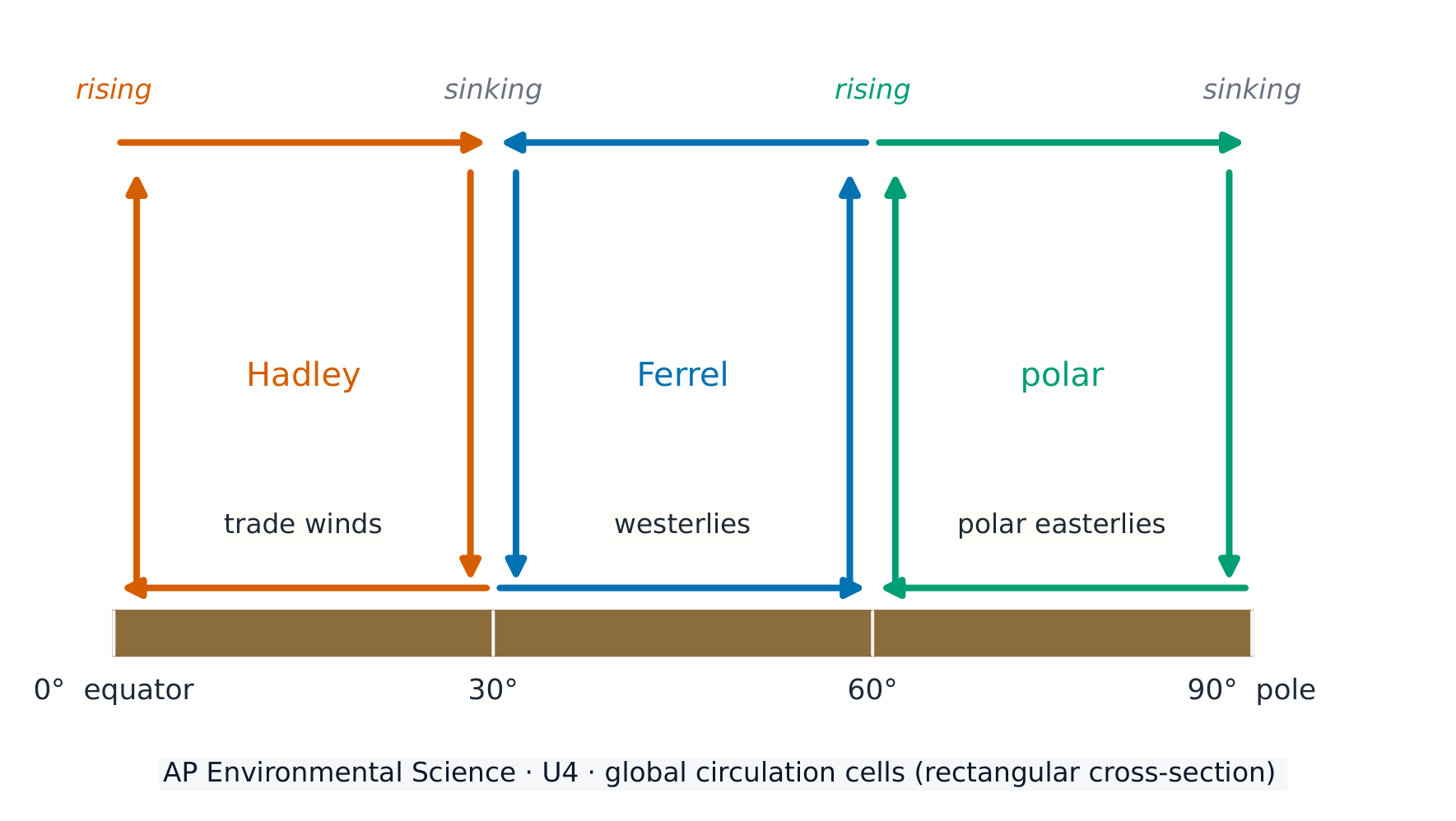
Uneven solar heating drives global wind patterns 全球风带. Warm air rises at the equator and sinks at about 30°, creating convection cells 对流环流 (Hadley, Ferrel, polar) and prevailing winds (trade winds, westerlies). The spinning Earth deflects winds – the Coriolis effect 科里奥利效应 – shaping weather and climate.

ไทย
รูปแบบลมทั่วโลก

การรับความร้อนจากดวงอาทิตย์ที่ไม่สม่ำเสมอขับเคลื่อน รูปแบบลมทั่วโลก อากาศร้อนยกตัวขึ้นที่เส้นศูนย์สูตรและจมลงที่ละติจูดประมาณ 30° สร้าง เซลล์การพาความร้อน (Hadley, Ferrel, ขั้วโลก) และลมประจำที่ (ลม贸易, ลมตะวันตก) โลกหมุนทำให้ลมเบี่ยงเบน – ปรากฏการณ์โคริโอลิส – ซึ่งมีผลต่อการกำหนดสภาพอากาศและภูมิอากาศ

เซลล์ circulation สามต่อซีกโลกกำหนดลมพื้นผิวประจำที่
4.6

Watersheds · ⁨พื้นที่ลุ่มน้ำ⁩

Syllabus · ⁨หลักสูตร⁩
English

Enduring Understanding (ERT-4): Earth's systems interact, resulting in a state of balance over time.

Learning Objective ERT-4.F: Describe the characteristics of a watershed.

  • ERT-4.F.1 Characteristics of a given watershed include its area, length, slope, soil, vegetation types, and divides with adjoining watersheds.
ไทย

ความเข้าใจที่ยั่งยืน (ERT-4): ระบบของโลกมีปฏิสัมพันธ์กัน ส่งผลให้เกิดสมดุลในช่วงเวลาหนึ่ง

วัตถุประสงค์การเรียนรู้ ERT-4.F: อธิบายลักษณะของลำน้ำ

  • ERT-4.F.1 ลักษณะของลำน้ำที่กำหนด ได้แก่ พื้นที่ ความชัน ความยาว ดิน ชนิดพืชพรรณและแนวแบ่ง其与相邻流域。

Source: College Board AP Course and Exam Description · ⁨แหล่งที่มา: คำอธิบายหลักสูตรและข้อสอบ College Board AP⁩

English

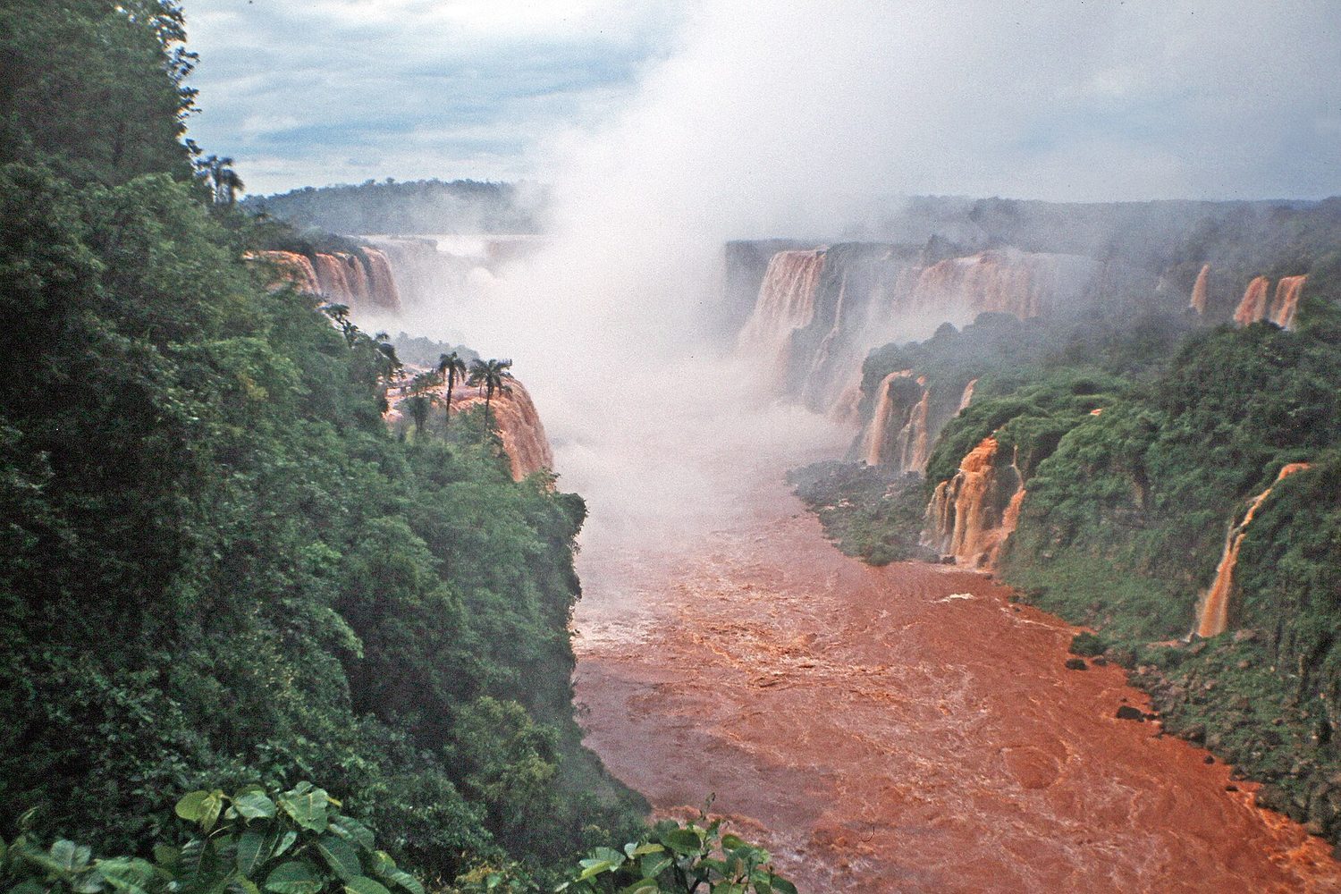
A watershed 流域 is all the land that drains to a common body of water. Everything that happens on the land – farming, paving, pollution – affects the water it drains into, so watersheds are key units for managing water quality.

ไทย

พื้นที่ลุ่มน้ำ คือพื้นที่ทั้งหมดที่ระบายน้ำเข้าสู่แหล่งน้ำเดียวกัน ทุกสิ่งที่เกิดขึ้นบนพื้นดิน – การเกษตร การ鋪路面 มลพิษ – ส่งผลต่อน้ำที่ระบายเข้าไป ดังนั้นพื้นที่ลุ่มน้ำจึงเป็นหน่วยสำคัญสำหรับการจัดการคุณภาพน้ำ

น้ำตกใน流域แม่น้ำ: พื้นที่ลุ่มน้ำคือพื้นที่ที่ระบายน้ำเข้าสู่ลำน้ำหรือทะเลสาบ
Vocabulary · ⁨คำศัพท์⁩ Train · ⁨ฝึกฝน⁩
English ไทย
watershed/ˈwɔːtəʃed/ พื้นที่รับน้ำ (watershed)
rain shadow/reɪn ˈʃædəʊ/ เงาฝน (rain shadow)
El Niño/el ˈniːnjəʊ/ เอล_columns (El Niño)
La Niña/læ ˈniːnjə/ ลา_columns (La Niña)
4.7

Solar Radiation and Earth's Seasons · ⁨รังสีจากดวงอาทิตย์และฤดูกาลของโลก⁩

Syllabus · ⁨หลักสูตร⁩
English

Enduring Understanding (ENG-2): Most of the Earth's atmospheric processes are driven by input of energy from the sun.

Learning Objective ENG-2.A: Explain how the sun's energy affects the Earth's surface.

  • ENG-2.A.1 Incoming solar radiation (insolation) is the Earth's main source of energy and is dependent on season and latitude.
  • ENG-2.A.2 The angle of the sun's rays determines the intensity of the solar radiation. Due to the shape of the Earth, the latitude that is directly horizontal to the solar radiation receives the most intensity.
  • ENG-2.A.3 The highest solar radiation per unit area is received at the equator and decreases toward the poles.
  • ENG-2.A.4 The solar radiation received at a location on the Earth's surface varies seasonally, with the most radiation received during the location's longest summer day and the least on the shortest winter day.
  • ENG-2.A.5 The tilt of Earth's axis of rotation causes the Earth's seasons and the number of hours of daylight in a particular location on the Earth's surface.
ไทย

ความเข้าใจที่ยั่งยืน (ENG-2): กระบวนการส่วนใหญ่ของบรรยากาศของโลกขับเคลื่อนด้วยพลังงานจากดวงอาทิตย์

วัตถุประสงค์การเรียนรู้ ENG-2.A: อธิบายว่าพลังงานจากดวงอาทิตย์ส่งผลต่อพื้นผิวโลกอย่างไร

  • ENG-2.A.1 รังสีอาทิตย์เข้า (insolation) เป็นแหล่งพลังงานหลักของโลกและขึ้นอยู่กับฤดูกาลและละติจูด
  • ENG-2.A.2 มุมของแสงอาทิตย์กำหนดความเข้มของรังสีสุริยะ เนื่องจากลักษณะของโลก เสาอากาศที่รับแสงอาทิตย์ในแนวตั้งฉากจะได้รับพลังงานมากที่สุด
  • ENG-2.A.3 รังสีสุริยะต่อหน่วยพื้นที่สูงสุดจะเกิดขึ้นที่เส้นศูนย์สูตร และลดลงเมื่อเข้าใกล้ขั้วโลก
  • ENG-2.A.4 รังสีสุริยะที่ได้รับในบริเวณใดบริเวณหนึ่งของพื้นผิวโลกจะเปลี่ยนแปลงตามฤดูกาล โดยได้รับรังสีมากที่สุดในช่วงวันที่ยาวที่สุดของฤดูร้อนและน้อยที่สุดในช่วงวันสั้นที่สุดของฤดูหนาว
  • ENG-2.A.5 การเอียงของแกนหมุนของโลกเป็นสาเหตุที่ทำให้เกิดฤดูกาลและจำนวนชั่วโมงกลางวันในพื้นที่เฉพาะบนพื้นผิวโลก

Source: College Board AP Course and Exam Description · ⁨แหล่งที่มา: คำอธิบายหลักสูตรและข้อสอบ College Board AP⁩

English

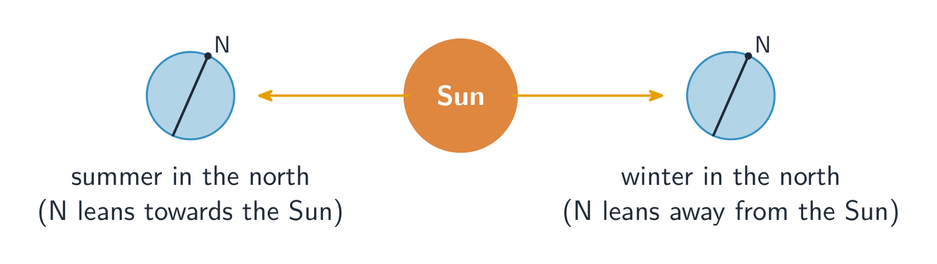
Seasons come from Earth's tilted axis (about 23.5°), not its distance from the Sun. The hemisphere tilted toward the Sun gets more direct sunlight and longer days (summer). The tilt also makes the tropics warm year-round and the poles cold.

ไทย

ฤดูกาล เกิดจาก แกนเอียงของโลก (ประมาณ 23.5°) ไม่ใช่ระยะห่างจากดวงอาทิตย์半球ที่เอียงเข้าหาดวงอาทิตย์จะได้รับแสงแดดโดยตรงมากขึ้นและมีวันยาวกว่า (ฤดูร้อน) การเอียงนี้ยังทำให้ เขตร้อน อุ่นตลอดปีและ ขั้วโลก เย็น

การเอียงของแกนโลกทำให้เกิดฤดูกาล
4.8

Earth's Geography and Climate · ⁨ภูมิศาสตร์และภูมิอากาศของโลก⁩

Syllabus · ⁨หลักสูตร⁩
English

Enduring Understanding (ENG-2): Most of the Earth's atmospheric processes are driven by input of energy from the sun.

Learning Objective ENG-2.B: Describe how the Earth's geography affects weather and climate.

  • ENG-2.B.1 Weather and climate are affected not only by the sun's energy but by geologic and geographic factors, such as mountains and ocean temperature.
  • ENG-2.B.2 A rain shadow is a region of land that has become drier because a higher elevation area blocks precipitation from reaching the land.
ไทย

ความเข้าใจที่ยั่งยืน (ENG-2): กระบวนการส่วนใหญ่ของบรรยากาศของโลกขับเคลื่อนด้วยพลังงานจากดวงอาทิตย์

วัตถุประสงค์การเรียนรู้ ENG-2.B: อธิบายว่าภูมิศาสตร์ของโลกส่งผลต่อสภาพอากาศและภูมิอากาศอย่างไร

  • ENG-2.B.1 สภาพอากาศและภูมิอากาศไม่เพียงแต่ได้รับอิทธิพลจากพลังงานของดวงอาทิตย์ แต่ยังได้รับอิทธิพลจากปัจจัยทางธรณีวิทยาและภูมิศาสตร์ เช่น ภูเขาและอุณหภูมิของมหาสมุทร
  • ENG-2.B.2 ฝนเงา (rain shadow) คือพื้นที่บนแผ่นดินที่มีสภาพแห้งแล้งขึ้นเนื่องจากพื้นที่สูงกั้นการตกของฝนไม่ให้เข้าถึงดิน

Source: College Board AP Course and Exam Description · ⁨แหล่งที่มา: คำอธิบายหลักสูตรและข้อสอบ College Board AP⁩

English

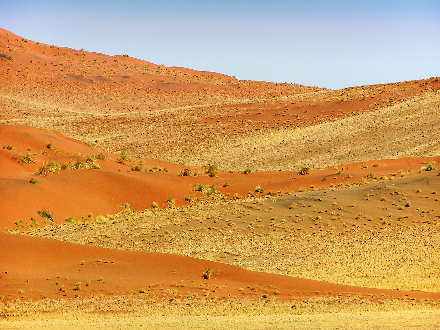
Geography shapes climate: latitude (sunlight angle), elevation (cooler with height), proximity to oceans (moderating temperature), and mountains creating a rain shadow 雨影 (wet windward side, dry leeward side). These factors decide which biome forms where.

ไทย

ภูมิศาสตร์กำหนดสภาพอากาศ: ละติจูด (มุมแสงอาทิตย์), ระดับความสูง (เย็นลงเมื่อสูงขึ้น), ความใกล้ชิดกับ มหาสมุทร (ปรับอุณหภูมิให้ไม่สุดขั้ว), และภูเขาที่สร้าง เงาฝน (ฝั่งลมมรสุมเปียก, ฝั่งลมน้ำแห้ง) ปัจจัยเหล่านี้กำหนดว่าระบบนิเวศใดจะเกิดขึ้นในพื้นที่ใด

ทะเลทรายและเนินทราย: ละติจูด, ระดับความสูง และกระแสน้ำทะเลกำหนดเขตภูมิอากาศของโลก
4.9

El Nino and La Nina · ⁨เอล นินโญ่ และ ลา นินิยา⁩

Syllabus · ⁨หลักสูตร⁩
English

Enduring Understanding (ENG-2): Most of the Earth's atmospheric processes are driven by input of energy from the sun.

Learning Objective ENG-2.C: Describe the environmental changes and effects that result from El Niño or La Niña events (El Niño–Southern Oscillation).

  • ENG-2.C.1 El Niño and La Niña are phenomena associated with changing ocean surface temperatures in the Pacific Ocean. These phenomena can cause global changes to rainfall, wind, and ocean circulation patterns.
  • ENG-2.C.2 El Niño and La Niña are influenced by geological and geographic factors and can affect different locations in different ways.
ไทย

ความเข้าใจที่ยั่งยืน (ENG-2): กระบวนการส่วนใหญ่ของบรรยากาศของโลกขับเคลื่อนด้วยพลังงานจากดวงอาทิตย์

วัตถุประสงค์การเรียนรู้ ENG-2.C: อธิบายการเปลี่ยนแปลงทางสิ่งแวดล้อมและผลกระทบที่เกิดจากเหตุการณ์เอล_columnsño หรือลา_columnsña (El_columnsño–Southern Oscillation)

  • ENG-2.C.1 เอล_columnsño และลา_columnsña เป็นปรากฏการณ์ที่เกี่ยวข้องกับการเปลี่ยนแปลงอุณหภูมิผิวน้ำในมหาสมุทรแปซิฟิก ปรากฏการณ์เหล่านี้สามารถก่อให้เกิดการเปลี่ยนแปลงในระดับโลกด้านปริมาณฝน ลม และรูปแบบการไหลเวียนของน้ำทะเล
  • ENG-2.C.2 เอล_columnsño และลา_columnsinya受 geological and geographic factors influence and can affect different locations in different ways.

Source: College Board AP Course and Exam Description · ⁨แหล่งที่มา: คำอธิบายหลักสูตรและข้อสอบ College Board AP⁩

English
El Niño and La Niña

El Niño 厄尔尼诺 and La Niña 拉尼娜 are periodic shifts in Pacific Ocean temperatures and winds. El Niño (warm eastern Pacific) and La Niña (cool eastern Pacific) alter rainfall, storms, and fisheries worldwide – for example, floods in some regions and droughts in others.

Worked example. A tectonic plate moves 5 cm per year. How far does it travel in 1 million years? $5\ \text{cm/yr}\times 10^{6}\ \text{yr}=5\times10^{6}\ \text{cm}=50\ \text{km}$. A tiny yearly motion adds up to ocean-basin-scale distances over geologic time — the same slow rate that opens oceans and builds mountain ranges.

ไทย
เอล นินโญ่ และ ลา นินิยา

เอล นินโญ่ และ ลา นินิยา คือการเปลี่ยนแปลงแบบเป็นรอบของอุณหภูมิและลมในมหาสมุทรแปซิฟิก เอล นินโญ่ (น้ำอุ่นทางตะวันออกของแปซิฟิก) และ ลา นินิยา (น้ำเย็นทางตะวันออกของแปซิฟิก) เปลี่ยนแปลงปริมาณฝน ภัยพายุ และทรัพยากรประมง ทั่วโลก – เช่น น้ำท่วมในบางพื้นที่และภัยแล้งในอีกหลายพื้นที่

ตัวอย่างวิธีทำ. แผ่นเปลือกโลกเคลื่อนที่ปีละ 5 เซนติเมตร จะเคลื่อนที่ได้ไกลแค่ไหนใน 1 ล้านปี? $5\ \text{cm/yr}\times 10^{6}\ \text{yr}=5\times10^{6}\ \text{cm}=50\ \text{km}$. การเคลื่อนที่เล็กน้อยในแต่ละปีสะสมเป็นระยะทางระดับอ่าวมหาสมุทรตามช่วงเวลาทางธรณีวิทยา – ซึ่งมีความเร็วช้าเช่นเดียวกันกับการเปิดอ่าวมหาสมุทรและการก่อตัวขึ้นของเทือกเขา

4.9

Exam tips · ⁨ข้อแนะนำสำหรับการสอบ⁩

English
  • Seasons come from the Earth's tilt, not its distance from the Sun.
  • Soil forms very slowly, so erosion faster than formation permanently depletes it; know soil texture (sand/silt/clay) and horizons.
  • Explain global wind patterns from uneven heating + the Coriolis effect, and a rain shadow (wet windward, dry leeward).
  • Name the atmospheric layers (troposphere = weather, stratosphere = ozone) and air composition (~78% N₂, 21% O₂).
  • El Niño / La Niña are Pacific temperature shifts that change rainfall worldwide.
ไทย
  • ฤดูกาลเกิดจากการเอียงของแกนโลก ไม่ใช่ระยะห่างจากดวงอาทิตย์
  • ดินก่อตัวช้ามาก ดังนั้น การกัดเซาะที่เร็วกว่าการก่อตัว จึงทำให้ดินเสื่อมโทรมถาวร; ต้องรู้จักลักษณะเนื้อดิน (ทราย/ตะกอน/ดินเหนียว) และชั้นดิน
  • อธิบายรูปแบบลมระดับโลกจากการให้ความร้อนไม่สม่ำเสมอ + ผลโคริโอลิส, และ เงาฝน (ฝั่งลมมรสุมเปียก, ฝั่งลมน้ำแห้ง).
  • ชื่อชั้นบรรยากาศ (ทროโพสเฟียร์ = อากาศ, สตราโตสเฟียร์ = โอโซน) และองค์ประกอบของอากาศ (~78% N₂, 21% O₂).
  • เอล นินโญ่ / ลา นินิยา คือการเปลี่ยนแปลงอุณหภูมินิรปดแปซิฟิกที่ส่งผลต่อปริมาณฝนทั่วโลก

Interactive lessons on this topic · ⁨บทเรียนเชิงโต้ตอบสำหรับหัวข้อนี้⁩

Work through it step by step, with instant-check exercises. · ⁨ทำทีละขั้นตอน พร้อมแบบฝึกหัดตรวจสอบผลทันที⁩

Past Papers · ⁨ข้อสอบย้อนหลัง⁩

More topics in AP Environmental Science · ⁨หัวข้อเพิ่มเติมใน AP Environmental Science⁩

Log in or create account · ⁨เข้าสู่ระบบหรือสร้างบัญชี⁩

IGCSE, A-Level & AP