Skip to content · ⁨الانتقال إلى المحتوى⁩

Earth Systems and Resources · ⁨أنظمة الأرض والموارد⁩

AP Environmental Science · ⁨AP العلوم البيئية⁩ · Topic 4 · ⁨الموضوع 4⁩

Video lesson for this topic · ⁨درس فيديو لهذا الموضوع⁩ Open the video page · ⁨افتح صفحة الفيديو⁩
7:28

أنظمة الأرض والموارد

مدينتان تبعدان عن بعضهما四十 كيلومتراً، على جانبي سلسلة جبلية واحدة. إحداها تتلقى ثلاثة أمتار من الأمطار سنوياً — وهي غابة مطيرة. والأخرى تتلقى أقل من ذلك…

English narration · English + 中文 subtitles burned in · ⁨سرد باللغة الإنجليزية · ترجمة مدمجة بالإنجليزية + الصينية⁩

4.1

Plate Tectonics · ⁨تكتونية الصفائح⁩

Syllabus · ⁨المنهج⁩
English

Enduring Understanding (ERT-4): Earth's systems interact, resulting in a state of balance over time.

Learning Objective ERT-4.A: Describe the geological changes and events that occur at convergent, divergent, and transform plate boundaries.

  • ERT-4.A.1 Convergent boundaries can result in the creation of mountains, island arcs, earthquakes, and volcanoes.
  • ERT-4.A.2 Divergent boundaries can result in seafloor spreading, rift valleys, volcanoes, and earthquakes.
  • ERT-4.A.3 Transform boundaries can result in earthquakes.
  • ERT-4.A.4 Maps that show the global distribution of plate boundaries can be used to determine the location of volcanoes, island arcs, earthquakes, hot spots, and faults.
  • ERT-4.A.5 An earthquake occurs when stress overcomes a locked fault, releasing stored energy.
العربية

الفهم الدائم (ERT-4): تتفاعل أنظمة الأرض مما يؤدي إلى حالة من التوازن بمرور الوقت.

هدف التعلم ERT-4.A: صف التغيرات الجيولوجية والأحداث التي تحدث عند حدود الصفائح المتقاربة والمتباعدة والمتحولة.

  • ERT-4.A.1 يمكن أن تؤدي الحدود المتقاربة إلى تكوين الجبال، وأقواس الجزر، والزلازل، والبراكين.
  • ERT-4.A.2 يمكن أن تؤدي الحدود المتباعدة إلى تمدد قاع المحيط، ووديان الشقوق، والبراكين، والزلازل.
  • ERT-4.A.3 يمكن أن تؤدي الحدود المتحولة إلى الزلازل.
  • ERT-4.A.4 يمكن استخدام الخرائط التي تظهر التوزيع العالمي لحدود الصفائح لتحديد مواقع البراكين، وأقواس الجزر، والزلازل، والنقاط الساخنة، والكسور.
  • ERT-4.A.5 يحدث الزلزال عندما يتغلب الضغط على كسر مقفل، مما يحرر الطاقة المخزنة.
Source: College Board AP Course and Exam Description · ⁨المصدر: وصف دورة وامتحان College Board AP⁩

English
The three plate boundaries

Earth's crust is broken into plates 板块 that slowly move on the mantle – plate tectonics 板块构造. At divergent boundaries plates spread apart (new crust); at convergent they collide (mountains, volcanoes, earthquakes); at transform they slide past (earthquakes). Boundaries create hazards but also volcanic soils and mineral resources.

العربية
حدود الصفائح الثلاث

قشرة الأرض مقسمة إلى صفائح تتحرك ببطء فوق الوشاح – تكتونية الصفائح. عند الحدود المتباعدة تبعد الصفائح عن بعضها (قشرة جديدة)؛ عند المتقاربة تتصادم (جبال، براكين، زلازل)؛ عند التحول تنزلق جنبًا إلى جنب (زلازل). الحدود تخلق مخاطر لكنها تولد أيضًا تربة بركانية وموارد معدنية.

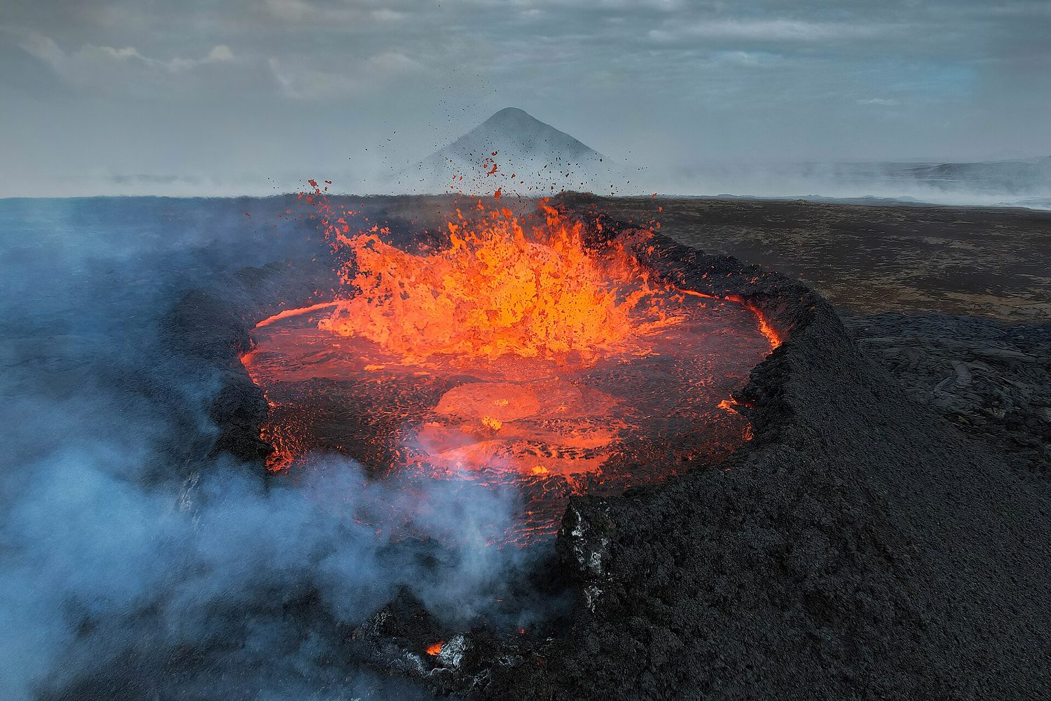
حمم بركانية برتقالية لامعة تنفجر من فوهة بركان داكنة في آيسلندا
بركانثوران عند حد صفيحي في آيسلندا. الصخر المنصهر الصاعد بين الصفائح المتباعدة يبني قشرة جديدة
Vocabulary · ⁨مفردات⁩ Train · ⁨تدريب⁩
English العربية
plates/pleɪts/ الصفيحات
plate tectonics/pleɪt tekˈtɒnɪks/ تكتونية الصفائح
4.2

Soil Formation and Erosion · ⁨تكون التربة والتعرية⁩

Syllabus · ⁨المنهج⁩
English

Enduring Understanding (ERT-4): Earth's systems interact, resulting in a state of balance over time.

Learning Objective ERT-4.B: Describe the characteristics and formation of soil.

  • ERT-4.B.1 Soils are formed when parent material is weathered, transported, and deposited.
  • ERT-4.B.2 Soils are generally categorized by horizons based on their composition and organic material.
  • ERT-4.B.3 Soils can be eroded by winds or water. Protecting soils can protect water quality as soils effectively filter and clean water that moves through them.
العربية

الفهم الدائم (ERT-4): تتفاعل أنظمة الأرض مما يؤدي إلى حالة من التوازن بمرور الوقت.

هدف التعلم ERT-4.B: صف خصائص التربة وتكوينها.

  • ERT-4.B.1 تتكون التربة عندما تتعفن المادة الأم، وتنقل، وتترسب.
  • ERT-4.B.2 تُصنف التربة بشكل عام حسب الطبقات بناءً على تركيبها والمادة العضوية.
  • ERT-4.B.3 يمكن تعرية التربة بواسطة الرياح أو الماء. حماية التربة يمكن أن تحمي جودة المياه حيث تعمل التربة بكفاءة على تصفية وتنقية المياه التي تمر خلالها.

Source: College Board AP Course and Exam Description · ⁨المصدر: وصف دورة وامتحان College Board AP⁩

English

Soil 土壤 forms slowly as rock weathers 风化 and organic matter builds up. Erosion 侵蚀 is the removal of soil by wind and water, sped up by removing vegetation (farming, deforestation, overgrazing). Because soil forms so slowly, erosion faster than formation depletes a vital resource.

العربية

التربة تتكون ببطء بينما تتآكل الصخور وتتراكم المواد العضوية. التعرية هي إزالة التربة بواسطة الرياح والماء، وتتسارع بسبب إزالة الغطاء النباتي (الزراعة، قطع الأشجار، الرعي الجائر). نظرًا لأن التربة تتكون ببطء شديد، فإن التعرية التي أسرع من التكوين تستنزف موردًا حيويًا.

طبقات التربة تتشكل بمرور الوقت بينما تتآكل الصخر الأم؛ يمكن للتعرية نزع التربة السطحية وعكس ذلك التقدم
Vocabulary · ⁨مفردات⁩ Train · ⁨تدريب⁩
English العربية
Soil/sɔɪl/ التربة
weathers/ˈweðəz/ تتآكل
Erosion/ɪˈrəʊʒn/ التعرية
texture/ˈtekstʃə/ ملمس
4.3

Soil Composition and Properties · ⁨مكونات التربة وخصائصها⁩

Syllabus · ⁨المنهج⁩
English

Enduring Understanding (ERT-4): Earth's systems interact, resulting in a state of balance over time.

Learning Objective ERT-4.C: Describe similarities and differences between properties of different soil types.

  • ERT-4.C.1 Water holding capacity—the total amount of water soil can hold—varies with different soil types. Water retention contributes to land productivity and fertility of soils.
  • ERT-4.C.2 The particle size and composition of each soil horizon can affect the porosity, permeability, and fertility of the soil.
  • ERT-4.C.3 There are a variety of methods to test the chemical, physical, and biological properties of soil that can aid in a variety of decisions, such as irrigation and fertilizer requirements.
  • ERT-4.C.4 A soil texture triangle is a diagram that allows for the identification and comparison of soil types based on their percentage of clay, silt, and sand.
العربية

الفهم الدائم (ERT-4): تتفاعل أنظمة الأرض مما يؤدي إلى حالة من التوازن بمرور الوقت.

هدف التعلم ERT-4.C: صف أوجه التشابه والاختلاف بين خصائص أنواع التربة المختلفة.

  • ERT-4.C.1 تختلف سعة الاحتفاظ بالماء - وهي إجمالي كمية الماء التي يمكن للتربة حملها - باختلاف أنواع التربة. يساهم احتجاز الماء في إنتاجية الأراضي وخير التربة.
  • ERT-4.C.2 يمكن أن يؤثر حجم الحبيبات وتركيب كل طبقة من طبقات التربة على مسامية التربة ونفاذيتها وخيرتها.
  • ERT-4.C.3 هناك مجموعة متنوعة من الطرق لاختبار الخصائص الكيميائية والفيزيائية والبيولوجية للتربة التي يمكن أن تساعد في مجموعة متنوعة من القرارات، مثل متطلبات الري والأسمدة.
  • ERT-4.C.4 مثلث ملمس التربة هو رسم بياني يسمح بتحديد ومقارنة أنواع التربة بناءً على نسبتها المئوية من الطين والطمي والرمل.

Source: College Board AP Course and Exam Description · ⁨المصدر: وصف دورة وامتحان College Board AP⁩

English

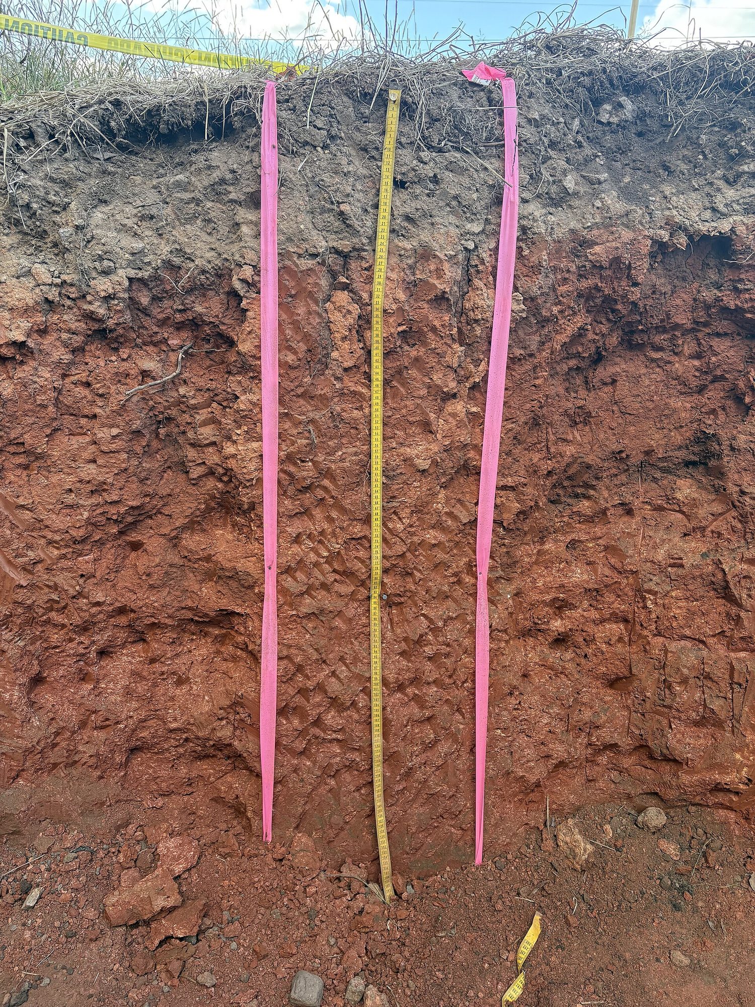
Soil is a mix of sand, silt, and clay (its texture 质地), plus organic matter, water, and air, layered in horizons 土层. Texture controls porosity 孔隙度 and permeability 渗透性 – how well soil holds water and nutrients. Loam (a balanced mix) is best for plants.

العربية

التربة مزيج من الرمل والطمي والطين (ملمسها)، بالإضافة إلى المواد العضوية والمياه والهواء، مرتبة في طبقات. يحدد الملمس المسامية والنفاذية – مدى قدرة التربة على احتجاز الماء والعناصر الغذائية. التراب الطميي (مزيج متوازن) هو الأفضل للنباتات.

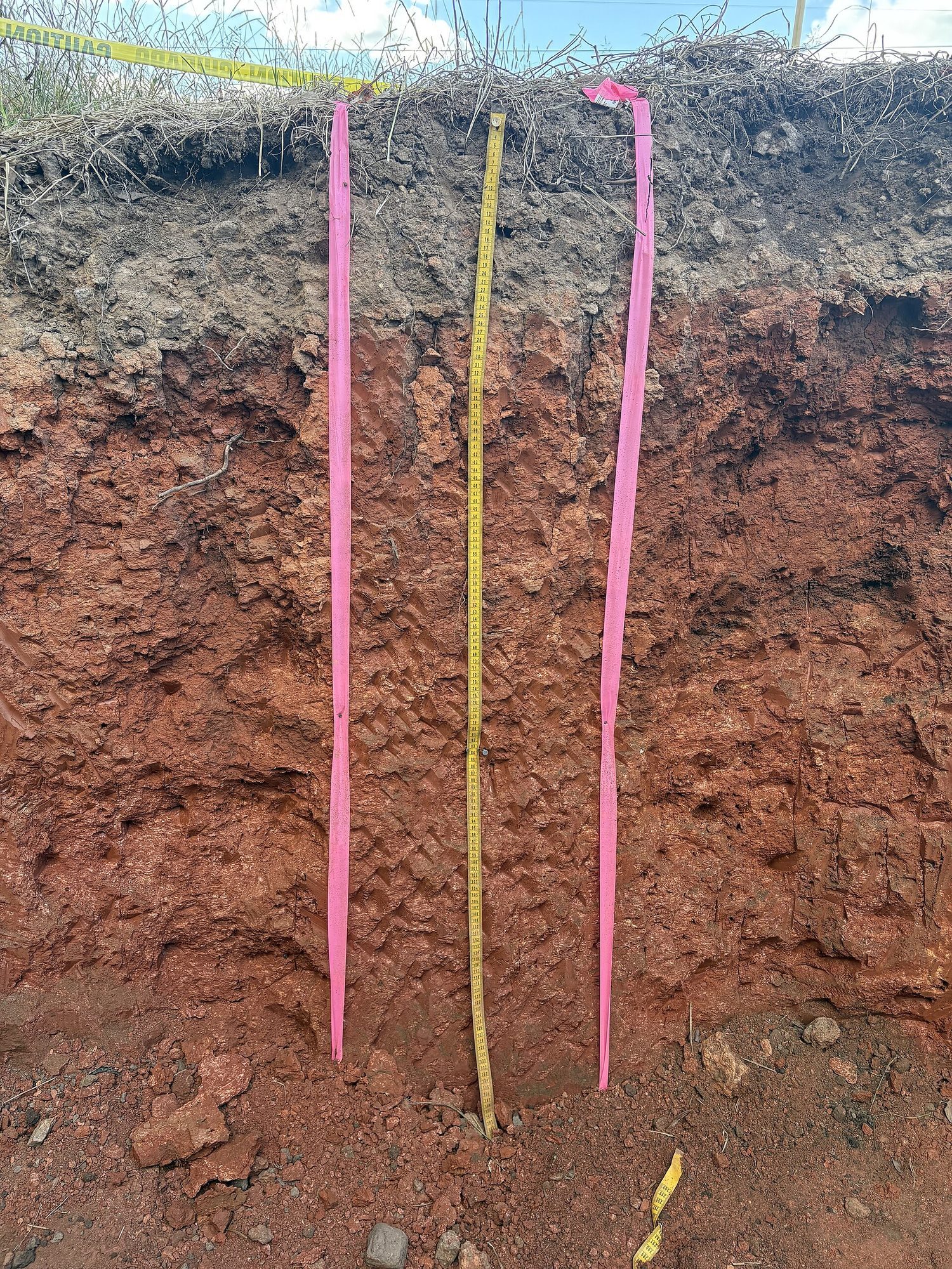
حفرة رأسية مقطوعة عبر التربة، تُظهر شريطًا من التربة السطحية الداكنة فوق طبقات معدنية ذات لون بني محمر، مع شريط قياس للمقياس
حفرة محفورة عبر التربة تُظهر طبقاتها: تربة سطحية عضوية داكنة في الأعلى، ثم طبقات معدنية أفتح لونًا، فوق صخور مكسورة (الشريط للمقياس)
Vocabulary · ⁨مفردات⁩ Train · ⁨تدريب⁩
English العربية
horizons/həˈraɪznz/ الطبقات
porosity/pɔːˈrɒsɪti/ المسامية
permeability/ˌpɜːməˈbɪlɪti/ النفاذية
atmosphere/ˈætməsfɪə/ الغلاف الجوي
troposphere/ˈtrɒpəsfɪə/ التروبوسفير
stratosphere/ˈstrætəsfɪə/ الستراتوسفير
global wind patterns/ˈɡləʊbl wɪnd ˈpætnz/ أنماط الرياح العالمية
convection cells/kənˈvekʃn selz/ خلايا الحمل الحراري
Coriolis effect/ˌkɒrɪˈəʊliz ɪˈfekt/ تأثير كوروليوس
4.4

Earth's Atmosphere · ⁨غلاف جوي الأرض⁩

Syllabus · ⁨المنهج⁩
English

Enduring Understanding (ERT-4): Earth's systems interact, resulting in a state of balance over time.

Learning Objective ERT-4.D: Describe the structure and composition of the Earth's atmosphere.

  • ERT-4.D.1 The atmosphere is made up of major gases, each with its own relative abundance.
  • ERT-4.D.2 The layers of the atmosphere are based on temperature gradients and include the troposphere, stratosphere, mesosphere, thermosphere, and exosphere.
العربية

الفهم الدائم (ERT-4): تتفاعل أنظمة الأرض مما يؤدي إلى حالة من التوازن بمرور الوقت.

هدف التعلم ERT-4.D: صف بنية وتركيب الغلاف الجوي للأرض.

  • ERT-4.D.1 يتكون الغلاف الجوي من غازات رئيسية، لكل منها كثافته النسبية الخاصة.
  • ERT-4.D.2 تعتمد طبقات الغلاف الجوي على التدرجات الحرارية وتشمل التروبوسفير، والاستراتوسفير، والميزوسفير، والثيرموسفير، والإكسوسفير.

Source: College Board AP Course and Exam Description · ⁨المصدر: وصف دورة وامتحان College Board AP⁩

English

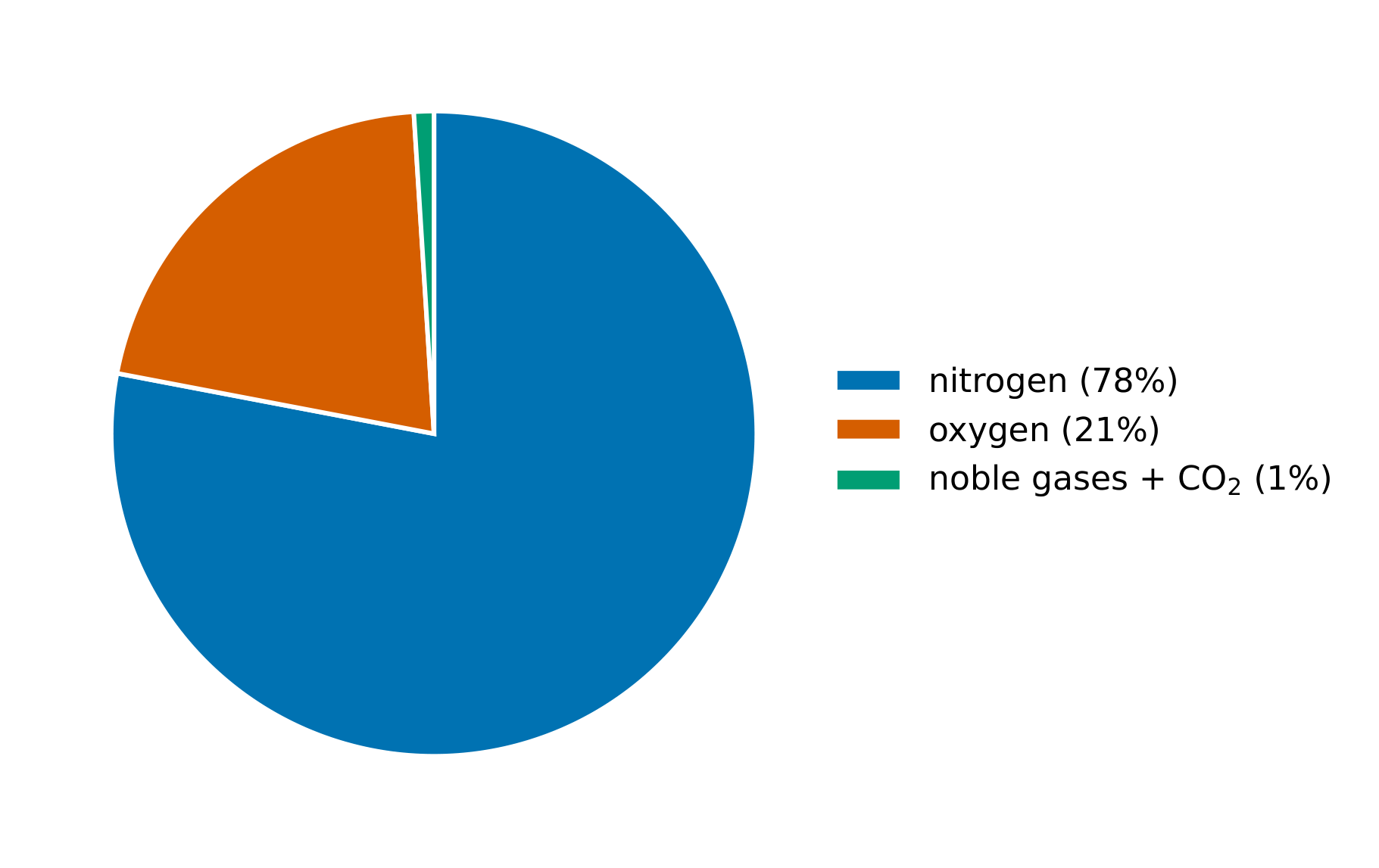
The atmosphere 大气层 is layered: the troposphere 对流层 (weather, where we live), the stratosphere 平流层 (holding the ozone layer), and higher layers. It is mostly nitrogen and oxygen, with trace gases (including greenhouse gases) that regulate temperature.

العربية

الغلاف الجوي الطبقات: التروبوسفير (الأرصاد الجوية، حيث نعيش)، الستراتوسفير (يحتوي على طبقة الأوزون)، والطبقات الأعلى. يتكون بشكل رئيسي من النيتروجين والأكسجين، مع غازات ضئيلة (بما فيها الغازات الدفيئة) تنظم درجة الحرارة.

الهواء النظيف الجاف يتكون تقريبًا من 78% نيتروجين، 21% أكسجين، و1% غازات أخرى
4.5

Global Wind Patterns · ⁨أنماط الرياح العالمية⁩

Syllabus · ⁨المنهج⁩
English

Enduring Understanding (ERT-4): Earth's systems interact, resulting in a state of balance over time.

Learning Objective ERT-4.E: Explain how environmental factors can result in atmospheric circulation.

  • ERT-4.E.1 Global wind patterns primarily result from the most intense solar radiation arriving at the equator, resulting in density differences and the Coriolis effect.
العربية

الفهم الدائم (ERT-4): تتفاعل أنظمة الأرض مما يؤدي إلى حالة من التوازن بمرور الوقت.

هدف التعلم ERT-4.E: اشرح كيف يمكن أن تؤدي العوامل البيئية إلى الدوران الجوي.

  • ERT-4.E.1 تنشأ أنماط الرياح العالمية بشكل أساسي من أشعة الشمس الأكثر كثافة التي تصل إلى خط الاستواء، مما يؤدي إلى فروق في الكثافة وتأثير كوريوليس.

Source: College Board AP Course and Exam Description · ⁨المصدر: وصف دورة وامتحان College Board AP⁩

English
Global wind patterns

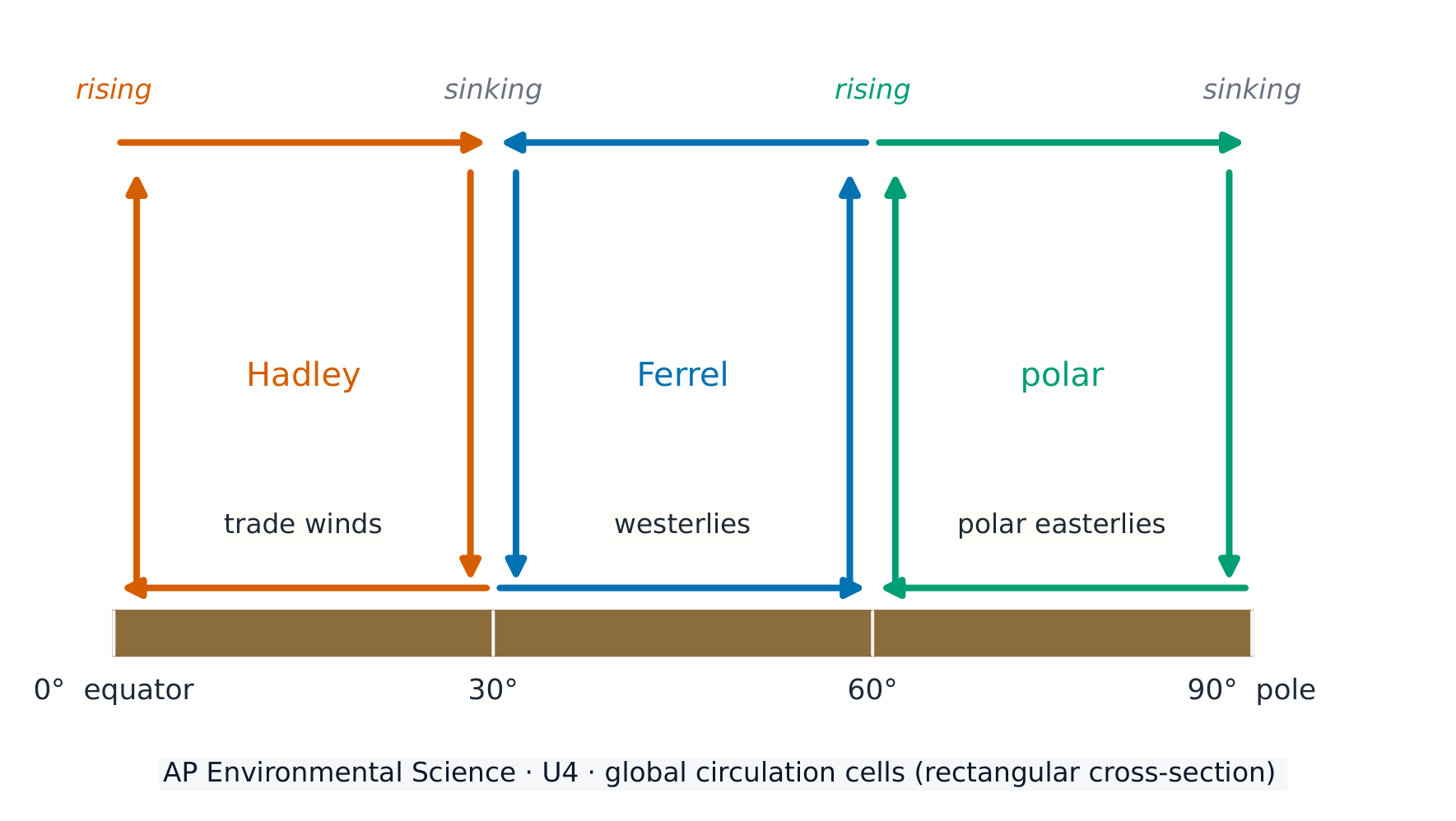
Uneven solar heating drives global wind patterns 全球风带. Warm air rises at the equator and sinks at about 30°, creating convection cells 对流环流 (Hadley, Ferrel, polar) and prevailing winds (trade winds, westerlies). The spinning Earth deflects winds – the Coriolis effect 科里奥利效应 – shaping weather and climate.

العربية
أنماط الرياح العالمية

التسخين الشمسي غير المتكافئ يحرك أنماط الرياح العالمية. يرتفع الهواء الدافئ عند خط الاستواء وينخفض عند حوالي 30°، مما يُنشئ خلايا الحمل الحراري (هادلي، فيريل، قطبية) والرياح السائدة (رياح التجارة، الغربيات). تدوير الأرض يحرف الرياح – تأثير كوريوليس – ويشكل الطقس والمناخ.

ثلاث خلايا دوران لكل نصف كرة تحدد الرياح السطحية السائدة
ثلاث خلايا دوران لكل نصف كرة تحدد رياح السطح السائدة
4.6

Watersheds · ⁨أحواض التصريف⁩

Syllabus · ⁨المنهج⁩
English

Enduring Understanding (ERT-4): Earth's systems interact, resulting in a state of balance over time.

Learning Objective ERT-4.F: Describe the characteristics of a watershed.

  • ERT-4.F.1 Characteristics of a given watershed include its area, length, slope, soil, vegetation types, and divides with adjoining watersheds.
العربية

الفهم الدائم (ERT-4): تتفاعل أنظمة الأرض مما يؤدي إلى حالة من التوازن بمرور الوقت.

هدف التعلم ERT-4.F: صف خصائص حوض التصريف.

  • ERT-4.F.1 تشمل خصائص حوض تصريف معين مساحته، وطوله، ومنحناه، وتربه، وأنواع النباتات، وفواصله مع أحواض التصريف المجاورة.

Source: College Board AP Course and Exam Description · ⁨المصدر: وصف دورة وامتحان College Board AP⁩

English

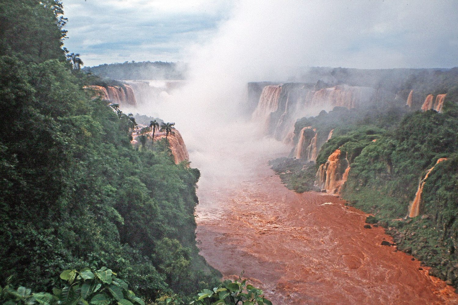
A watershed 流域 is all the land that drains to a common body of water. Everything that happens on the land – farming, paving, pollution – affects the water it drains into, so watersheds are key units for managing water quality.

العربية

حوض التصريف هو كل الأراضي التي تصرف إلى جسم مائي مشترك. كل ما يحدث على الأرض – الزراعة، الإسفلت، التلوث – يؤثر على المياه التي تصرف إليها، لذا تُعد أحواض التصريف وحدات أساسية لإدارة جودة المياه.

شلال في حوض نهري: حوض التصريف هو الأرض التي تصرف إلى مجرى مائي أو بحيرة
Vocabulary · ⁨مفردات⁩ Train · ⁨تدريب⁩
English العربية
watershed/ˈwɔːtəʃed/ حوض تصريف المياه
rain shadow/reɪn ˈʃædəʊ/ ظل المطر
El Niño/el ˈniːnjəʊ/ النينيو
La Niña/læ ˈniːnjə/ لا نينا
4.7

Solar Radiation and Earth's Seasons · ⁨الإشعاع الشمسي وفصول السنة⁩

Syllabus · ⁨المنهج⁩
English

Enduring Understanding (ENG-2): Most of the Earth's atmospheric processes are driven by input of energy from the sun.

Learning Objective ENG-2.A: Explain how the sun's energy affects the Earth's surface.

  • ENG-2.A.1 Incoming solar radiation (insolation) is the Earth's main source of energy and is dependent on season and latitude.
  • ENG-2.A.2 The angle of the sun's rays determines the intensity of the solar radiation. Due to the shape of the Earth, the latitude that is directly horizontal to the solar radiation receives the most intensity.
  • ENG-2.A.3 The highest solar radiation per unit area is received at the equator and decreases toward the poles.
  • ENG-2.A.4 The solar radiation received at a location on the Earth's surface varies seasonally, with the most radiation received during the location's longest summer day and the least on the shortest winter day.
  • ENG-2.A.5 The tilt of Earth's axis of rotation causes the Earth's seasons and the number of hours of daylight in a particular location on the Earth's surface.
العربية

الفهم الدائم (ENG-2): معظم العمليات الجوية للأرض مدفوعة بمدخلات الطاقة من الشمس.

هدف التعلم ENG-2.A: اشرح كيف يؤثر طاقة الشمس على سطح الأرض.

  • ENG-2.A.1 الإشعاع الشمسي الساقط (الإشعاع الداخل) هو المصدر الرئيسي للطاقة للأرض ويعتمد على الموسم وعرض الأرض.
  • ENG-2.A.2 يحدد زاوية أشعة الشمس شدة الإشعاع الشمسي. ونظرًا لشكل الأرض، فإن خط العرض الذي يكون مستويًا عموديًا على الأشعة الشمسية يستقبل أعلى درجة من الشدة.
  • ENG-2.A.3 يُستقبل أعلى إشعاع شمسي لكل وحدة مساحة عند خط الاستواء وينخفض نحو القطبين.
  • ENG-2.A.4 يتغير الإشعاع الشمسي المُستقبل في موقع ما على سطح الأرض موسميًا، حيث يُستقبل أكثر إشعاع خلال أطول يوم صيفي للموقع وأقل إشعاع في أقصر يوم شتوي.
  • ENG-2.A.5 يسبب ميلان محور دوران الأرض فصول السنة وعدد ساعات النهار في موقع محدد على سطح الأرض.

Source: College Board AP Course and Exam Description · ⁨المصدر: وصف دورة وامتحان College Board AP⁩

English

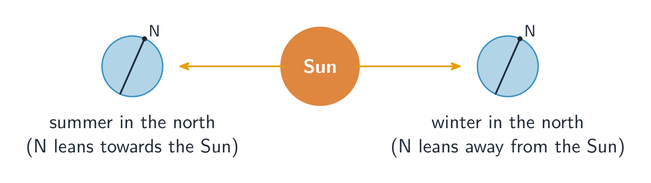
Seasons come from Earth's tilted axis (about 23.5°), not its distance from the Sun. The hemisphere tilted toward the Sun gets more direct sunlight and longer days (summer). The tilt also makes the tropics warm year-round and the poles cold.

العربية

الفصول ناتجة عن محور الأرض المائل (حوالي 23.5 درجة)، وليس مسافتها عن الشمس. نصف الكرة المائل نحو الشمس يحصل على ضوء شمس أكثر مباشرة وأيام أطول (الصيف). يجعل الميل أيضًا المناطق الاستوائية دافئة طوال العام والأقطاب باردة.

ميل محور الأرض يسبب الفصول
4.8

Earth's Geography and Climate · ⁨جغرافيا الأرض والمناخ⁩

Syllabus · ⁨المنهج⁩
English

Enduring Understanding (ENG-2): Most of the Earth's atmospheric processes are driven by input of energy from the sun.

Learning Objective ENG-2.B: Describe how the Earth's geography affects weather and climate.

  • ENG-2.B.1 Weather and climate are affected not only by the sun's energy but by geologic and geographic factors, such as mountains and ocean temperature.
  • ENG-2.B.2 A rain shadow is a region of land that has become drier because a higher elevation area blocks precipitation from reaching the land.
العربية

الفهم الدائم (ENG-2): معظم العمليات الجوية للأرض مدفوعة بمدخلات الطاقة من الشمس.

الهدف التعليمي ENG-2.B: صف كيف تؤثر جغرافية الأرض على الطقس والمناخ.

  • ENG-2.B.1 لا يتأثر الطقس والمناخ فقط بطاقة الشمس، بل أيضًا بالعوامل الجيولوجية والجغرافية مثل الجبال ودرجة حرارة المحيطات.
  • ENG-2.B.2 ظل المطر هو منطقة أرضية أصبحت أكثر جفافًا لأن ارتفاعًا أعلى يمنع هطول الأمطار من الوصول إلى تلك الأراضي.

Source: College Board AP Course and Exam Description · ⁨المصدر: وصف دورة وامتحان College Board AP⁩

English

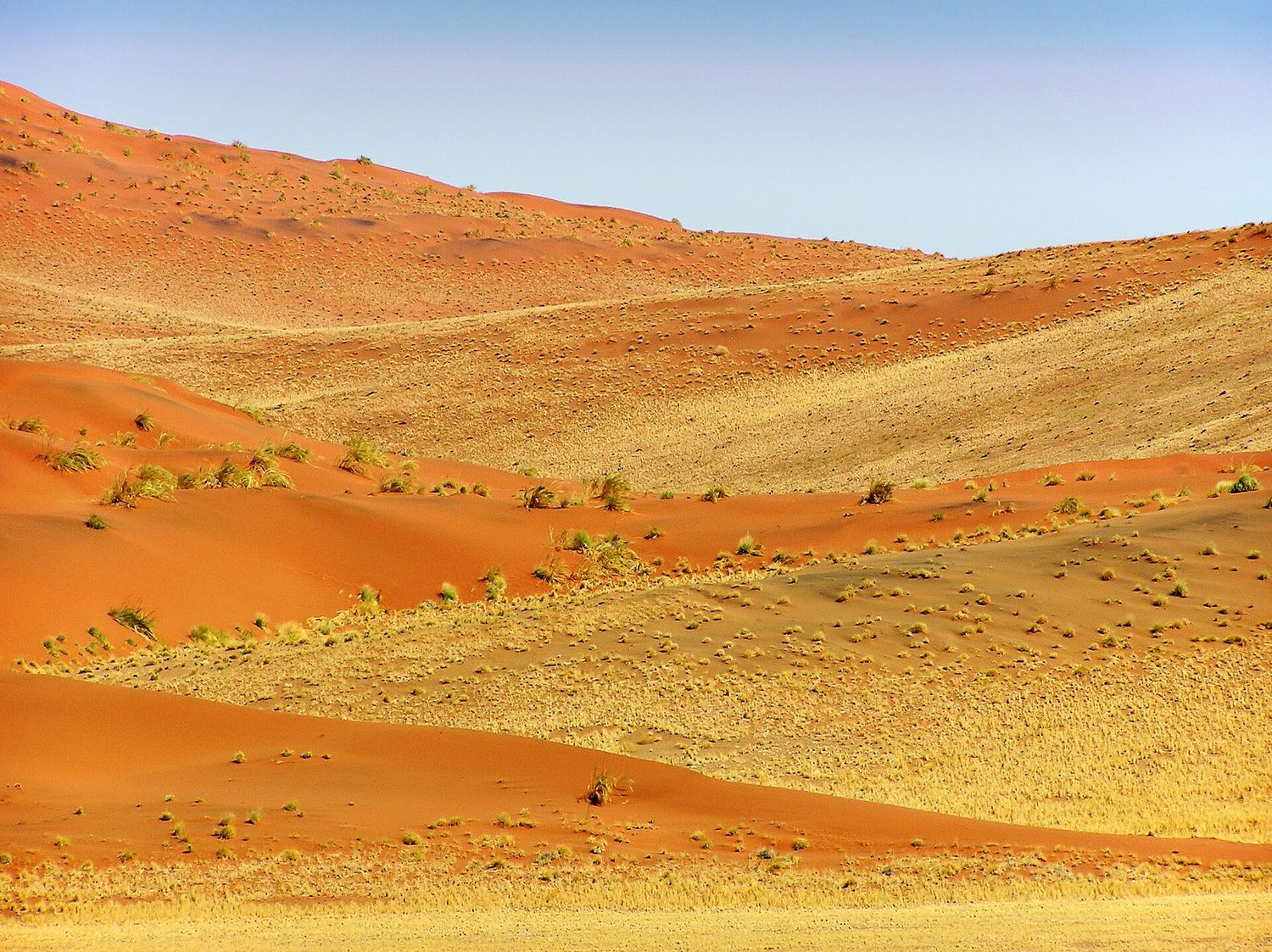
Geography shapes climate: latitude (sunlight angle), elevation (cooler with height), proximity to oceans (moderating temperature), and mountains creating a rain shadow 雨影 (wet windward side, dry leeward side). These factors decide which biome forms where.

العربية

تشكل الجغرافيا المناخ: الخطوط العرضية (زاوية أشعة الشمس)، الارتفاع عن سطح البحر (برودة مع الارتفاع)، القرب من المحيطات (تعتدل درجة الحرارة)، والجبال التي تُنشئ ظلًا ممطرًا (جهة رطبة迎风، وجانب جاف في الخلفية). تحدد هذه العوامل أي حيز بيئي يتشكل وأين.

رمل الصحراء: الخطوط العرضية والارتفاع وتيارات المحيط تشكل مناطق مناخ الأرض
4.9

El Nino and La Nina · ⁨إل نينو ولا نينا⁩

Syllabus · ⁨المنهج⁩
English

Enduring Understanding (ENG-2): Most of the Earth's atmospheric processes are driven by input of energy from the sun.

Learning Objective ENG-2.C: Describe the environmental changes and effects that result from El Niño or La Niña events (El Niño–Southern Oscillation).

  • ENG-2.C.1 El Niño and La Niña are phenomena associated with changing ocean surface temperatures in the Pacific Ocean. These phenomena can cause global changes to rainfall, wind, and ocean circulation patterns.
  • ENG-2.C.2 El Niño and La Niña are influenced by geological and geographic factors and can affect different locations in different ways.
العربية

الفهم الدائم (ENG-2): معظم العمليات الجوية للأرض مدفوعة بمدخلات الطاقة من الشمس.

الهدف التعليمي ENG-2.C: صف التغيرات البيئية والآثار الناتجة عن أحداث النينيو أو لانا نينا (التذبذب الجنوبي للنينيو).

  • ENG-2.C.1 النينيو ولانا نينا ظواهر مرتبطة بتغير درجات حرارة سطح المحيط في المحيط الهادئ. يمكن أن تسبب هذه الظواهر تغييرات عالمية في أنماط الهطول والرياح ودوران المحيطات.
  • ENG-2.C.2 تتأثر النينيو ولانا نينا بالعوامل الجيولوجية والجغرافية ويمكن أن تؤثر على مواقع مختلفة بطرق مختلفة.

Source: College Board AP Course and Exam Description · ⁨المصدر: وصف دورة وامتحان College Board AP⁩

English
El Niño and La Niña

El Niño 厄尔尼诺 and La Niña 拉尼娜 are periodic shifts in Pacific Ocean temperatures and winds. El Niño (warm eastern Pacific) and La Niña (cool eastern Pacific) alter rainfall, storms, and fisheries worldwide – for example, floods in some regions and droughts in others.

Worked example. A tectonic plate moves 5 cm per year. How far does it travel in 1 million years? $5\ \text{cm/yr}\times 10^{6}\ \text{yr}=5\times10^{6}\ \text{cm}=50\ \text{km}$. A tiny yearly motion adds up to ocean-basin-scale distances over geologic time — the same slow rate that opens oceans and builds mountain ranges.

العربية
إل نينو ولا نينا

إل نينو ولا نينا هما تحولات دورية في درجات حرارة المحيط الهادئ والرياح. يُغيّر إل نينو (محيط هادئ دافئ في الشرق) ولا نينا (محيط هادئ بارد في الشرق) هطول الأمطار والعواصف ومصايد الأسماك عالميًا – على سبيل المثال، الفيضانات في بعض المناطق والجفاف في أخرى.

مثال محلول. تتحرك صفيحة تكتونية بمقدار 5 سم سنوياً. كم المسافة التي تقطعها خلال 1 مليون سنة؟ $5\ \text{cm/yr}\times 10^{6}\ \text{yr}=5\times10^{6}\ \text{cm}=50\ \text{km}$. يتراكم الحركة السنوية الضئيلة لتصل إلى مسافات بحجم حوض المحيط عبر الزمن الجيولوجي — نفس المعدل البطيء الذي يفتح المحيطات ويبني سلاسل الجبال.

4.9

Exam tips · ⁨نصائح للامتحان⁩

English
  • Seasons come from the Earth's tilt, not its distance from the Sun.
  • Soil forms very slowly, so erosion faster than formation permanently depletes it; know soil texture (sand/silt/clay) and horizons.
  • Explain global wind patterns from uneven heating + the Coriolis effect, and a rain shadow (wet windward, dry leeward).
  • Name the atmospheric layers (troposphere = weather, stratosphere = ozone) and air composition (~78% N₂, 21% O₂).
  • El Niño / La Niña are Pacific temperature shifts that change rainfall worldwide.
العربية
  • تأتي الفصول من ميلان الأرض، وليس من مسافتها عن الشمس.
  • تتكون التربة ببطء شديد، لذا فإن التآسر faster than formation يستنفدها بشكل دائم؛ تعرف على ملمس التربة (رمل/طين/صلصال) والطبقات.
  • اشرح أنماط الرياح العالمية من خلال التسخين غير المتساوي + تأثير كوروليوس، وظلًا ممطرًا (وجه迎风 رطب، وجه leeward جاف).
  • سَمِّ طبقات الغلاف الجوي (التروبوسفير = الطقس، الاستراتوسفير = الأوزون) وتركيب الهواء (~78% N₂، 21% O₂).
  • إل نينو / لا نينا هي تحولات في درجة حرارة المحيط الهادئ تغير هطول الأمطار عالميًا.

Interactive lessons on this topic · ⁨دروس تفاعلية حول هذا الموضوع⁩

Work through it step by step, with instant-check exercises. · ⁨ا-working عليه خطوة بخطوة، مع تمارين تحقق فوري.⁩

Past Papers · ⁨أوراق الامتحانات السابقة⁩

More topics in AP Environmental Science · ⁨AP العلوم البيئية⁩ · ⁨المزيد من المواضيع في AP Environmental Science · ⁨AP العلوم البيئية⁩⁩

Log in or create account · ⁨تسجيل الدخول أو إنشاء حساب⁩

IGCSE, A-Level & AP