| Enduring Understanding | Learning Objective | Essential Knowledge |
|---|---|---|
IMP-1 | IMP-1.A |
|
地理思维
AP 人文地理 · 第 1 主题
 8:14
8:14
Thinking Geographically
Look at Greenland on a classroom world map. It looks about the size of Africa. It is not. Africa is fourteen times larger. <slow>The map is not lying to you by…
英文讲解 · 内嵌中英文字幕
1.1
地图导论
大纲
来源:美国大学理事会 AP 课程与考试说明
地理学是研究事物在哪里以及为什么在那里。它最基本的工具是地图(map)——地球表面某一部分的一幅压平的图片。
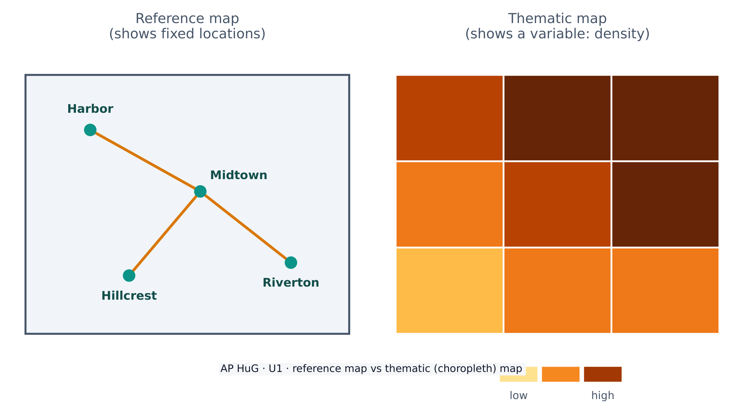
地图有两个大家族。一张参考地图(reference map)显示固定的位置——海岸线、边界、道路、城市(一本道路地图集或谷歌地图)。一张专题地图(thematic map)显示一个变量如何跨空间变化——降雨、收入,或人口密度。AP 人文地理不断地使用专题地图。
因为地球是一个球体而一张地图是平的,每张地图都使用一个把地球拉伸到纸上的投影(projection)。投影总是扭曲(distort)某样东西——形状、面积、距离,或方向。著名的墨卡托(Mercator)投影保持方向正确(对航海有用)但使像格陵兰这样的高纬度地方看起来太大。没有完美的投影;一个制图师选择一个适合地图目的的。
词汇表
训练
| 英文 | 中文 | 拼音 |
|---|---|---|
| map/mæp/ | 地图 | dì tú |
| reference map/ˈrefrəns mæp/ | 参考地图 | cān kǎo dì tú |
| thematic map/θiːˈmætɪk mæp/ | 专题地图 | zhuān tí dì tú |
| projection/prəˈdʒekʃn/ | 投影 | tóu yǐng |
| distort/dɪˈstɔːt/ | 扭曲 | niǔ qū |
1.2
地理数据
大纲
| Enduring Understanding | Learning Objective | Essential Knowledge |
|---|---|---|
IMP-1 | IMP-1.B |
|
来源:美国大学理事会 AP 课程与考试说明
地理数据(geographic data)是任何与一个位置绑定的信息。地理学家在实地(计数、勘测、访谈)并用技术远程收集它。
你必须知道的关键地理空间技术(geospatial technologies):
- GIS(地理信息系统,Geographic Information System)——层叠许多种空间数据以便模式能被比较的软件。
- GPS(卫星导航)——精确定位地球上的确切位置。
- 遥感(remote sensing)——在不接触地面的情况下从卫星或飞机收集数据。
数据也来自书面来源:实地观察、媒体报道、旅行写作、政策文件、访谈和照片。
词汇表
训练
| 英文 | 中文 | 拼音 |
|---|---|---|
| Geographic data/ˌdʒɪəˈɡræfɪk ˈdeɪtə/ | 地理数据 | dì lǐ shù jù |
| geospatial technologies/ˌdʒiːəʊˈspeɪʃl tekˈnɒlədʒiz/ | 地理空间技术 | dì lǐ kōng jiān jì shù |
| GIS/ˌdʒiː aɪ ˈes/ | 地理信息系统 | dì lǐ xìn xī xì tǒng |
| Remote sensing/rɪˈməʊt ˈsensɪŋ/ | 遥感 | yáo gǎn |
1.3
地理数据的力量
大纲
| Enduring Understanding | Learning Objective | Essential Knowledge |
|---|---|---|
IMP-1 | IMP-1.C |
|
来源:美国大学理事会 AP 课程与考试说明
数据强大,因为它驱动决定。企业用它来选择商店位置、政府用普查数据来规划学校和道路,而援助机构用它在一场灾害后送帮助。
但数据从不中立。谁收集它、他们用哪些类别,以及一张地图如何被绘制,都能塑造信息。一张地图能告知——或它能误导——所以一个好的地理学家总是问数据来自哪里以及它遗漏什么。
1.4
空间概念
大纲
| Enduring Understanding | Learning Objective | Essential Knowledge |
|---|---|---|
PSO-1 | PSO-1.A |
|
来源:美国大学理事会 AP 课程与考试说明
地理学家用一套精确的词汇描述位置和格局。
- 绝对位置(absolute location)是一个确切的地址——纬度和经度。相对位置(relative location)通过它附近的什么来描述一个地方("河的北面")。
- 绝对距离(absolute distance)以千米测量;相对距离(relative distance)以时间、成本或努力测量。
- 时空压缩(space–time compression)是随着交通和通信改善,地方之间感受到的距离的缩小。
- 距离衰减(distance decay)意味着两个地方之间的相互作用随着它们之间的距离增长而减弱。
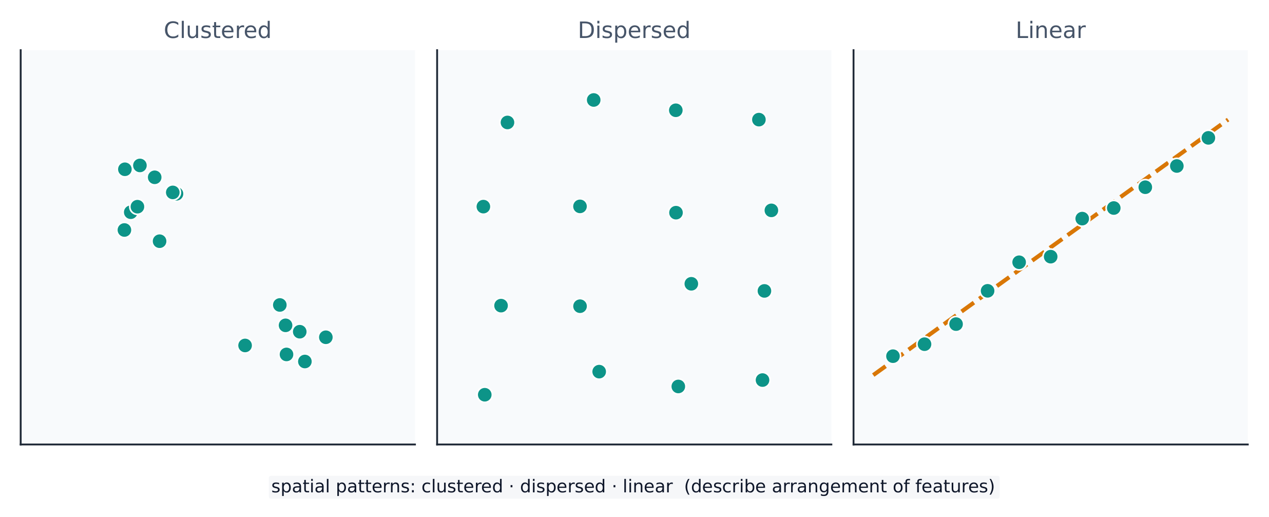
一个空间格局(spatial pattern)是事物如何排列:聚集(clustered)(挤在一起)、分散(dispersed)(分开),或线性(linear)(沿一条线,例如一条道路)。读格局是解释它为什么存在的第一步。
词汇表
训练
| 英文 | 中文 | 拼音 |
|---|---|---|
| Absolute location/ˈæbsəluːt ləʊˈkeɪʃn/ | 绝对位置 | jué duì wèi zhì |
| Relative location/ˈrelətɪv ləʊˈkeɪʃn/ | 相对位置 | xiāng duì wèi zhì |
| Space–time compression/speɪs taɪm kəmˈpreʃn/ | 时空压缩 | shí kōng yā suō |
| Distance decay/ˈdɪstəns dɪˈkeɪ/ | 距离衰减 | jù lí shuāi jiǎn |
| spatial pattern/ˈspeɪʃl ˈpætn/ | 空间格局 | kōng jiān gé jú |
| clustered/ˈklʌstəd/ | 聚集 | jù jí |
| dispersed/dɪˈspɜːst/ | 分散 | fēn sàn |
1.5
人类与环境的相互作用
大纲
| Enduring Understanding | Learning Objective | Essential Knowledge |
|---|---|---|
PSO-1 | PSO-1.B |
|
来源:美国大学理事会 AP 课程与考试说明
人和环境互相塑造。三个较旧的思想描述这个:
- 环境决定论(environmental determinism)——(现在被否定的)物理环境决定一个文化如何发展的主张。
- 可能论(possibilism)——被接受的观点,即环境设定限制,但人们用技术和文化选择如何回应。
文化景观(cultural landscape)——建在土地上的农场、城市和道路——是这种相互作用可见的结果。可持续性问人们如何能使用自然资源而不用尽它们。
词汇表
训练
| 英文 | 中文 | 拼音 |
|---|---|---|
| Environmental determinism/enˌvaɪrənˈmentl dɪˈtɜːmɪnɪzəm/ | 环境决定论 | huán jìng jué dìng lùn |
| Possibilism/ˈpɒsɪbɪlɪzəm/ | 可能论 | kě néng lùn |
| cultural landscape/ˈkʌltʃərəl ˈlændskeɪp/ | 文化景观 | wén huà jǐng guān |
1.6
分析尺度

大纲
| Enduring Understanding | Learning Objective | Essential Knowledge |
|---|---|---|
PSO-1 | PSO-1.C |
|
PSO-1.D |
|
来源:美国大学理事会 AP 课程与考试说明
分析尺度(scale of analysis)是你看数据的层级——全球、区域、国家或地方。同一个格局在不同的尺度看起来能完全不同。
例如,一个国家可能在国家尺度看起来富有,却在地方尺度包含很穷的社区。放大或缩小——改变尺度——揭示之前隐藏的格局。考试问题常常要求你"在各种尺度上"解释一个过程。
Worked example(一道真实的 AP 考题)。 "这幅地图聚焦于区域尺度。解释从一幅区域尺度地图得出国家尺度结论的一个可能局限。"(2025)满分答案:"这幅地图只显示一个区域,所以它的格局可能不代表整个国家——其他区域可能看起来很不同,所以在区域尺度得出的结论在国家尺度上会不准确。" 命令词 Explain(解释)要求推理:说出局限并且说明为什么改变尺度会改变格局。只写"尺度不同"不能得分。
词汇表
训练
| 英文 | 中文 | 拼音 |
|---|---|---|
| Scale of analysis/skeɪl ɒv əˈnæləsɪs/ | 分析尺度 | fēn xī chǐ dù |
1.7
区域分析
大纲
| Enduring Understanding | Learning Objective | Essential Knowledge |
|---|---|---|
SPS-1 | SPS-1.A |
|
来源:美国大学理事会 AP 课程与考试说明
一个区域(region)是一个有一个或更多共享特征使它与周围区域不同的地区。地理学家用三种类型:
- 正式(均质)区域(formal (uniform) region)——每个人共享一个可测量的特征(一个国家、一个小麦种植带、一个语言区)。
- 功能(节点)区域(functional (nodal) region)——围绕一个中央节点组织,像一座城市和它的通勤区或一家披萨店的送货区。
- 感知(方言)区域(perceptual (vernacular) region)——由人们的感觉和信念定义,有模糊的边界("美国南方"、"中东")。
区域由地理学家制造,不是在自然里找到的——所以它们的边界能被争论,这正是为什么它们对分析有用。
探索
Sort each example into the right kind of region
A formal region shares one measured trait, a functional region is organised around a node, and a perceptual region is defined by people's feelings.
词汇表
训练
| 英文 | 中文 | 拼音 |
|---|---|---|
| region/ˈriːdʒn/ | 区域 | qū yù |
| Formal (uniform) region/ˈfɔːml ˈriːdʒn/ | 均质区域 | jūn zhì qū yù |
| Functional (nodal) region/ˈfʌŋkʃənl ˈriːdʒn/ | 功能区域 | gōng néng qū yù |
| Perceptual (vernacular) region/pəˈseptʃuːəl ˈriːdʒn/ | 感知区域 | gǎn zhī qū yù |
1.7
考试技巧
- 总是命名一个地图投影的取舍:它保留什么与扭曲什么(墨卡托保持方向但夸大面积)。
- 陈述数据是定量还是定性的,并把一个来源(GIS、GPS、遥感、普查)匹配到它的用途。
- 把绝对与相对位置区分开,并在任何流动答案里使用距离衰减和时空压缩。
- 注意分析尺度:一个国家平均值隐藏地方变化——明确地说出来。
- 把每个区域分类为正式、功能或感知,并用定义特征论证它。
本主题的互动课程
逐步学习,并即时检测练习。