Bỏ qua nội dung

Tư duy địa lý

AP Địa lý Nhân loại · Chủ đề 1

Bài học video cho chủ đề này Mở trang video
8:14

Tư duy địa lý

Hãy nhìn Greenland trên bản đồ thế giới trong lớp học. Nó trông có kích thước tương đương với châu Phi. Điều đó không đúng. Châu Phi lớn hơn fourteen lần. <slow> Bản đồ không nói dối bạn bằng cách…

English narration · English and 中文 subtitles you can switch

1.1

Introduction to Maps

Chương trình

Hiểu biết dai dẳng (IMP-1): Các nhà địa lý sử dụng bản đồ và dữ liệu để mô tả mối quan hệ giữa thời gian, không gian và quy mô.

Mục tiêu học tập IMP-1.A: Xác định các loại bản đồ, các loại thông tin được trình bày trên bản đồ, và các dạng mẫu hình cũng như mối quan hệ không gian khác nhau được thể hiện trên bản đồ.

  • IMP-1.A.1 Các loại bản đồ bao gồm bản đồ tham khảo và bản đồ chuyên đề.
  • IMP-1.A.2 Các loại mẫu hình không gian được biểu diễn trên bản đồ bao gồm khoảng cách và hướng tuyệt đối và tương đối, phân cụm, phân tán, và độ cao.
  • IMP-1.A.3 Tất cả các bản đồ đều mang tính chọn lọc trong thông tin; phép chiếu bản đồ không tránh khỏi làm biến đổi mối quan hệ không gian về hình dạng, diện tích, khoảng cách và hướng.

Nguồn: Mô tả Khóa học và Bài thi College Board AP

English

In late August 1854 cholera killed more than 500 people in ten days around Broad Street in Soho, London. The doctor John Snow marked each death as a bar on a street map and saw that the deaths clustered around one public water pump. On 8 September the parish took the pump's handle off. Snow's map is one of the most famous in history because the pattern on the map pointed to the cause. Unit 1 teaches the tools of geography: maps, data, spatial concepts, scale and regions.

In this unit you will:

  • Read and compare reference maps 参考地图, thematic maps 专题地图 and map projections 地图投影.
  • Explain how geographers collect geographic data 地理数据, and how they use it.
  • Use spatial concepts such as location 位置, place 地方, distance decay 距离衰减 and time-space compression 时空压缩.
  • Explain human-environment interaction.
  • Explain how scale 尺度 changes what we see, and define three kinds of region 区域.

A reference map shows where things are: roads, borders, cities. A thematic map shows how one variable changes across space.

Thematic map How it shows data Example
Choropleth map 分级统计图 Shades or colours areas by value Income per state
Dot density map 点密度图 One dot = a set number of cases Each dot = 1,000 people
Graduated symbol map 分级符号图 Bigger symbol = bigger value Circles sized by city population
Isoline map 等值线图 Lines join points of equal value Contour lines of elevation
Cartogram 变形地图 Sizes countries by a variable, not land area Countries sized by population
Reference maps show location; thematic maps show how a variable varies over space
Reference maps show where things are; thematic maps show how one variable changes across space

Every flat map distorts the round Earth. The Mercator projection 墨卡托投影 (1569) keeps directions true, which made it useful for sailors, but it stretches areas near the poles: Greenland looks about as big as Africa, though Africa is about fourteen times larger. Equal-area projections keep areas correct but distort shapes. The Robinson projection is a compromise that distorts everything a little.

Từ vựng Luyện tập
English Tiếng Việt
reference maps reference maps
thematic maps thematic maps
map projections map projections
geographic data/ˌdʒɪəˈɡræfɪk ˈdeɪtə/ geographic data
location/ləʊˈkeɪʃn/ The place or position where something is situated.
place/pleɪs/ place
distance decay/ˈdɪstəns dɪˈkeɪ/ The tendency for interaction or influence between places to weaken as distance or the difficulty of travel increases.
time-space compression/taɪm speɪs kəmˈpreʃn/ The shrinking of effective distance as transport and communication speed up.
scale/skeɪl/ The size of something, especially in relation to other objects, its surroundings or an intended viewer.
region/ˈriːdʒn/ Khu vực
choropleth map choropleth map
dot density map dot density map
graduated symbol map graduated symbol map
isoline map isoline map
cartogram cartogram
Mercator projection/mɜːˈkeɪtə prəˈdʒekʃn/ Phép chiếu Mercator
1.2

Geographic Data

Chương trình

Hiểu biết dai dẳng (IMP-1): Các nhà địa lý sử dụng bản đồ và dữ liệu để mô tả mối quan hệ giữa thời gian, không gian và quy mô.

Mục tiêu học tập IMP-1.B: Xác định các phương pháp thu thập dữ liệu địa lý khác nhau.

  • IMP-1.B.1 Dữ liệu có thể được thu thập tại hiện trường bởi các tổ chức hoặc cá nhân.
  • IMP-1.B.2 Công nghệ không gian bao gồm hệ thống thông tin địa lý (GIS), hệ thống định vị vệ tinh, cảm biến từ xa, và bản đồ trực tuyến cùng với công cụ trực quan hóa.
  • IMP-1.B.3 Thông tin không gian có thể đến từ các tài liệu viết dưới dạng quan sát thực địa, báo cáo truyền thông, câu chuyện du lịch, tài liệu chính sách, phỏng vấn cá nhân, phân tích cảnh quan, và giải thích ảnh chụp.

Nguồn: Mô tả Khóa học và Bài thi College Board AP

English

Geographers collect data in two ways.

  • Field observation 实地观察 and interviews: going to a place, counting, photographing and asking people.
  • Data from institutions: the census (the United States has counted its population every ten years since 1790), government statistics and company records.

Technology collects data at a larger scale.

  • Remote sensing 遥感: satellites and aircraft photograph the Earth, for example to measure forest loss in the Amazon.
  • GPS 全球定位系统 (Global Positioning System): satellites give the exact position of a phone or vehicle, usually to within a few metres.
  • A photograph can show a busy street, but it cannot tell you the population density: for that you need counts of people and area.
A street-level photograph of Shibuya Crossing: visual evidence does not supply population density
Shibuya Crossing in Tokyo looks crowded, but a photograph cannot measure population density: that needs counts of people per square kilometre
Từ vựng Luyện tập
English Tiếng Việt
field observation field observation
remote sensing/rɪˈməʊt ˈsensɪŋ/ Collecting data about the Earth from satellites or aircraft.
GPS/ˌdʒiː piː ˈes/ Hệ thống định vị toàn cầu
Xem bài học
1.3

The Power of Geographic Data

Chương trình

Hiểu biết dai dẳng (IMP-1): Các nhà địa lý sử dụng bản đồ và dữ liệu để mô tả mối quan hệ giữa thời gian, không gian và quy mô.

Mục tiêu học tập IMP-1.C: Giải thích các tác động địa lý của các quyết định được đưa ra dựa trên thông tin địa lý.

  • IMP-1.C.1 Dữ liệu không gian và địa lý, bao gồm số liệu điều tra dân số và hình ảnh vệ tinh, được sử dụng ở mọi quy mô cho mục đích ra quyết định cá nhân, doanh nghiệp/tổ chức, và chính phủ.

Nguồn: Mô tả Khóa học và Bài thi College Board AP

English

A geographic information system (GIS) 地理信息系统 stores data in layers on the same map, so that patterns can be compared. A city planner looking for a site for a new school could layer the homes of children under ten, existing schools, main roads and flood zones, and look for a place close to many children, far from other schools and outside the flood zone.

A GIS stacks data layers on the same map so patterns can be compared
A GIS stacks data layers on the same map so that patterns can be compared

Governments and businesses use geographic data to make decisions: where to build hospitals, where to send ambulances, where to open shops, how to draw election districts. During the COVID-19 pandemic, online maps of cases by area helped governments decide where to impose restrictions.

Từ vựng Luyện tập
English Tiếng Việt
geographic information system (GIS) geographic information system (GIS)
1.4

Spatial Concepts

Chương trình

Hiểu biết dai dẳng (PSO-1): Các nhà địa lý phân tích các mối quan hệ bên trong và giữa các nơi để tiết lộ các mẫu hình không gian quan trọng.

Mục tiêu học tập PSO-1.A: Định nghĩa các khái niệm địa lý chính minh họa cho mối quan hệ không gian.

  • PSO-1.A.1 Các khái niệm không gian bao gồm vị trí tuyệt đối và tương đối, không gian, nơi chốn, dòng chảy, suy giảm theo khoảng cách, nén không-thời gian, và mẫu hình.

Nguồn: Mô tả Khóa học và Bài thi College Board AP

English
  • Absolute location 绝对位置 is a precise position, usually latitude and longitude: Beijing is at about 39.9°N, 116.4°E.
  • Relative location 相对位置 describes a place in relation to others: Singapore lies at the southern end of the Strait of Malacca, on one of the world's busiest shipping routes.
  • Place is what makes a location special: its people, buildings, language and feelings attached to it.
  • Distance decay: the farther apart two places are, the less they interact. Most customers of a corner shop live within a few streets.
  • Time-space compression: technology reduces the time it takes to cross distance. If a new train cuts a 20 km trip from 40 minutes to 20, the distance stays 20 km, but the place feels twice as close.
Distance decay: interaction falls as distance grows

Things on a map form patterns 格局: they can be clustered 聚集 (shops in a city centre), dispersed 分散 (farms on a plain) or linear 线状 (towns along a river or railway).

Points on the land can be clustered, dispersed, or arranged along a line
Points can be clustered, dispersed or arranged along a line: the pattern itself is evidence
Từ vựng Luyện tập
English Tiếng Việt
absolute location/ˈæbsəluːt ləʊˈkeɪʃn/ A precise position, usually latitude and longitude: Beijing is at about 39.
relative location/ˈrelətɪv ləʊˈkeɪʃn/ The position of a place described through its relationships with other places, such as direction, travel time or accessibility.
patterns/ˈpætnz/ patterns
clustered/ˈklʌstəd/ tập trung
dispersed/dɪˈspɜːst/ phân tán
linear/ˈlɪnɪə/ linear
Xem bài học
1.5

Human-Environmental Interaction

Chương trình

Hiểu biết dai dẳng (PSO-1): Các nhà địa lý phân tích các mối quan hệ bên trong và giữa các nơi để tiết lộ các mẫu hình không gian quan trọng.

Mục tiêu học tập PSO-1.B: Giải thích cách các khái niệm địa lý chính minh họa cho mối quan hệ không gian.

  • PSO-1.B.1 Các khái niệm về thiên nhiên và xã hội bao gồm tính bền vững, tài nguyên thiên nhiên, và sử dụng đất.
  • PSO-1.B.2 Các lý thuyết về tương tác giữa môi trường tự nhiên với các xã hội con người đã phát triển từ chủ nghĩa quyết định môi trường sang chủ nghĩa khả năng.

Nguồn: Mô tả Khóa học và Bài thi College Board AP

English

People use and change the environment, and the environment limits what people can do.

  • Natural resources 自然资源: water, soil, forests and minerals; using them sustainably 可持续地 means not using them faster than they are replaced.
  • Environmental determinism 环境决定论 is the old, rejected idea that the physical environment decides how a society develops.
  • Possibilism 可能论 argues that the environment sets limits, but people choose how to respond: the Netherlands built dikes and reclaimed land from the sea.
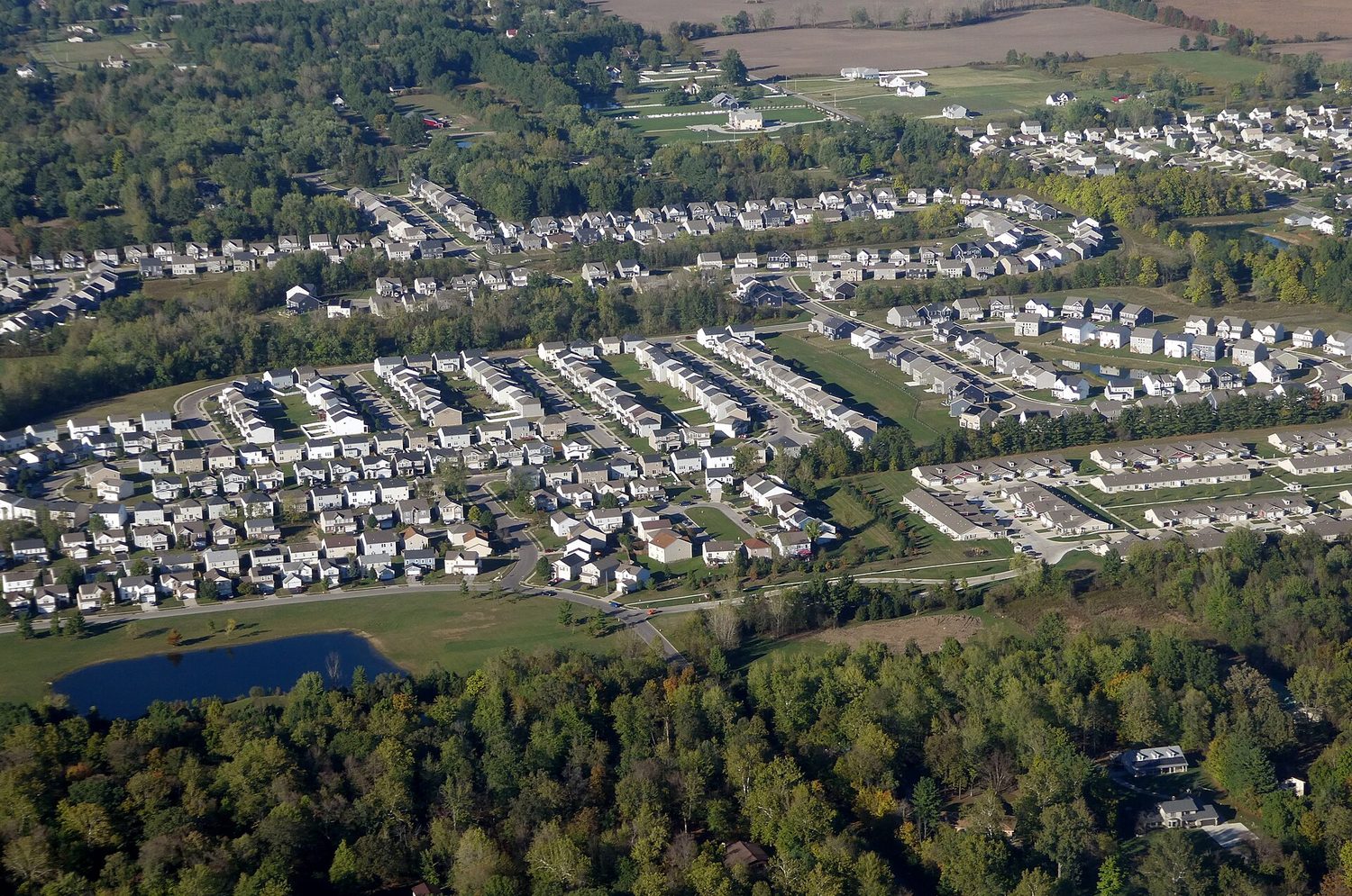
Urban sprawl at the city edge: human–environment interaction reshapes landscapes
Urban sprawl at a city's edge: housing replaces farmland and forest
Từ vựng Luyện tập
English Tiếng Việt
natural resources/ˈnætʃərəl rɪˈzɔːsɪz/ natural resources
sustainably/səˈsteɪnəbli/ sustainably
environmental determinism/enˌvaɪrənˈmentl dɪˈtɜːmɪnɪzəm/ The rejected view that physical environments largely determine societies' cultures and development, overlooking human agency and other influences.
possibilism/ˈpɒsɪbɪlɪzəm/ possibilism
1.6

Scales of Analysis

Chương trình

Hiểu biết dai dẳng (PSO-1): Các nhà địa lý phân tích các mối quan hệ bên trong và giữa các nơi để tiết lộ các mẫu hình không gian quan trọng.

Mục tiêu học tập PSO-1.C: Định nghĩa các quy mô phân tích mà các nhà địa lý sử dụng.

  • PSO-1.C.1 Các quy mô phân tích bao gồm toàn cầu, khu vực, quốc gia, và địa phương.

Mục tiêu học tập PSO-1.D: Giải thích những gì các quy mô phân tích tiết lộ.

  • PSO-1.D.1 Các mẫu hình và quá trình ở các quy mô khác nhau tiết lộ sự biến đổi và các cách diễn giải khác nhau về dữ liệu.

Nguồn: Mô tả Khóa học và Bài thi College Board AP

English

Geographers study patterns at different scales of analysis 分析尺度: global, regional, national and local. A pattern at one scale can disappear or reverse at another.

One illustrative arrangement of scales; regions can also cross borders or lie within countries
The same place sits inside larger and larger scales, and the scale you choose changes the pattern you see

China's national average income hides large differences between provinces, and a provincial average hides differences between cities and villages. A question about why a city is rich needs local data; a question about world trade needs global data.

Map scale 比例尺 is different: it is the ratio of distance on the map to distance on the ground. A large-scale map (1:10,000) shows a small area in detail; a small-scale map (1:10,000,000) shows a large area with little detail.

Từ vựng Luyện tập
English Tiếng Việt
scales of analysis scales of analysis
map scale map scale
1.7

Regional Analysis

Chương trình

Hiểu biết dai dẳng (SPS-1): Các nhà địa lý phân tích các vấn đề phức tạp và mối quan hệ với một góc nhìn không gian đặc thù.

Mục tiêu học tập SPS-1.A: Mô tả các cách khác nhau mà các nhà địa lý định nghĩa khu vực.

  • SPS-1.A.1 Các khu vực được định nghĩa dựa trên một hoặc nhiều đặc điểm thống nhất hoặc dựa trên các mẫu hình hoạt động.
  • SPS-1.A.2 Các loại khu vực bao gồm khu vực chính thức, khu vực chức năng, và khu vực nhận thức/dân gian.
  • SPS-1.A.3 Ranh giới khu vực mang tính chuyển tiếp và thường bị tranh chấp cũng như chồng lấn.
  • SPS-1.A.4 Các nhà địa lý áp dụng phân tích khu vực ở các quy mô địa phương, quốc gia, và toàn cầu.

Nguồn: Mô tả Khóa học và Bài thi College Board AP

English

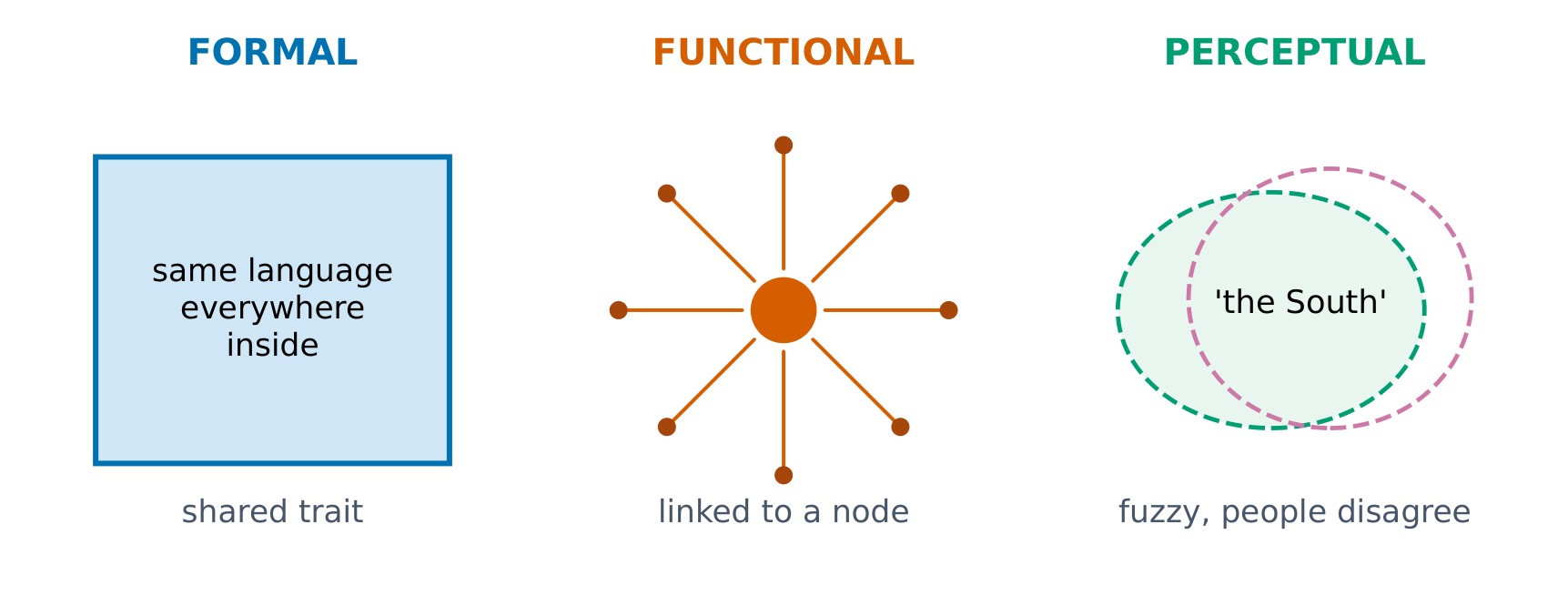
A region is an area that shares something that makes it different from the areas around it. There are three kinds.

  • Formal region 形式区域: everyone in it shares a measurable trait, such as a language, a crop or a political border. The US Corn Belt, where most farmland grows corn, is a formal region.
  • Functional region 功能区域: organised around a central node 节点 and the connections to it, such as the area served by an airport, or the commuter area of a city.
  • Perceptual region 感知区域 (vernacular region): defined by people's feelings and ideas, such as "the American South" or "the Midwest"; people disagree about its borders.
Formal, functional and perceptual regions

The same place can belong to several regions. Shanghai is in the formal region where Wu Chinese is spoken, at the centre of the functional region of the Yangtze River Delta economy, and in people's idea of "eastern China".

Khám phá

Phân loại từng ví dụ vào đúng loại vùng

A formal region chia sẻ một đặc điểm đo lường, a functional region được tổ chức quanh một nút, và a perceptual region được xác định bởi cảm nhận của con người.

Từ vựng Luyện tập
English Tiếng Việt
formal region/ˈfɔːml ˈriːdʒn/ formal region
functional region/ˈfʌŋkʃənl ˈriːdʒn/ An area organised around a centre or network of interactions, such as commuting, transport or trade.
node/nəʊd/ An individual unit or point in a network, graph, tree or linked data structure.
perceptual region/pəˈseptʃuːəl ˈriːdʒn/ An area identified through people's shared perceptions or sense of identity rather than a single measurable boundary rule.
1.7

Worked example: a free-response question

English

Free-response parts use command verbs. Identify needs a term or example; describe needs its features; explain shows how or why.

(a) Identify ONE type of thematic map that could show population by country.

(b) Describe ONE limitation of the Mercator projection.

(c) Explain how the scale of analysis can change the conclusion drawn from income data.

Model answer.

  • (a) A choropleth map, shading each country by its population density.
  • (b) The Mercator projection makes areas near the poles look much too large: Greenland appears similar in size to Africa, although Africa is about fourteen times larger.
  • (c) At the national scale China's average income may suggest a middle-income country, but at the provincial scale it shows that eastern coastal provinces earn far more than western ones, so a national average hides regional inequality.
1.7

Worked example: reading distance decay

English

A shop records where its 200 customers live.

Distance from shop Customers
0–1 km 120
1–2 km 50
2–3 km 20
3 km or more 10

Step 1: describe the pattern. 120 of 200 customers, 60 per cent, live within 1 km; the number falls with every extra kilometre.

Step 2: name the concept. This is distance decay: interaction falls as distance increases.

Step 3: explain. Travelling farther costs more time and money, and people farther away have other shops closer to them. A delivery service would weaken the pattern: an example of time-space compression.

1.7

Common errors

English
  • Calling every map "thematic": a road map is a reference map.
  • Saying the Mercator projection is "wrong": it keeps direction true, but distorts area.
  • Mixing up map scale with the scale of analysis.
  • Confusing absolute location (coordinates) with relative location (position compared to other places).
  • Calling a city's commuter area a formal region: it is functional, organised around a node.
  • Using environmental determinism as a valid explanation.
1.7

Key terms

English

thematic map: A map that shows how one variable changes across space.

map projection: A way of showing the round Earth on a flat map, which always causes some distortion.

GIS: A computer system that stores and compares geographic data in layers.

remote sensing: Collecting data about the Earth from satellites or aircraft.

distance decay: The decline of interaction as distance increases.

time-space compression: The reduction in the time it takes to cross distance, due to technology.

scale of analysis: The level, from local to global, at which a pattern is studied.

functional region: A region organised around a node and the connections to it.

1.7

Check yourself

English
  • Which thematic map uses lines that join points of equal value?
  • A shopping mall attracts shoppers from a 30 km area. What kind of region is this?
  • Give one example of possibilism.

Answers: An isoline map. A functional region, organised around the mall as a node. For example, the Netherlands building dikes to reclaim land from the sea (or irrigation turning a desert into farmland).

1.7

Sources for this lesson

English

College Board, AP Human Geography Course and Exam Description, Unit 1, topics 1.1–1.7 (syllabi/ap/ap_human_geography_CED.pdf). Projections: USGS projection uses and the USGS working manual. Position accuracy: GPS.gov. The practice questions are written for this course, not taken from past papers.

Bài học tương tác về chủ đề này

Làm theo từng bước, kèm theo bài tập kiểm tra ngay lập tức.

Đề thi cũ

Nhiều chủ đề hơn trong AP Địa lý Nhân loại

Đăng nhập hoặc tạo tài khoản

IGCSE, A-Level & AP