Skip to content · ⁨ข้ามไปยังเนื้อหา⁩

Thinking Geographically · ⁨การคิดเชิงภูมิศาสตร์⁩

AP Human Geography · ⁨AP ภูมิศาสตร์มนุษย์⁩ · Topic 1 · ⁨หัวข้อ 1⁩

Video lesson for this topic · ⁨บทเรียนวิดีโอสำหรับหัวข้อนี้⁩ Open the video page · ⁨เปิดหน้าวิดีโอ⁩
8:14

Thinking Geographically · ⁨การคิดเชิงภูมิศาสตร์⁩

Look at Greenland on a classroom world map. It looks about the size of Africa. It is not. Africa is fourteen times larger. <slow>The map is not lying to you by…

English narration · English + 中文 subtitles burned in · ⁨การบรรยายภาษาอังกฤษ · คำบรรยายภาษาอังกฤษ + 中文 ลอยตัวบนภาพ⁩

1.1

Introduction to Maps · ⁨การแนะนำแผนที่⁩

Syllabus · ⁨หลักสูตร⁩
English

Enduring Understanding (IMP-1): Geographers use maps and data to depict relationships of time, space, and scale.

Learning Objective IMP-1.A: Identify types of maps, the types of information presented in maps, and different kinds of spatial patterns and relationships portrayed in maps.

  • IMP-1.A.1 Types of maps include reference maps and thematic maps.
  • IMP-1.A.2 Types of spatial patterns represented on maps include absolute and relative distance and direction, clustering, dispersal, and elevation.
  • IMP-1.A.3 All maps are selective in information; map projections inevitably distort spatial relationships in shape, area, distance, and direction.
ไทย

ความเข้าใจที่ยั่งยืน (IMP-1): นักภูมิศาสตร์ใช้แผนที่และข้อมูลเพื่อแสดงความสัมพันธ์ของเวลา พื้นที่ และสเกล

วัตถุประสงค์การเรียนรู้ IMP-1.A: ระบุประเภทของแผนที่ ประเภทของข้อมูลที่นำเสนอในแผนที่ และรูปแบบเชิงพื้นที่และความสัมพันธ์ต่างๆ ที่ปรากฏในแผนที่

  • IMP-1.A.1 ประเภทของแผนที่รวมถึงแผนที่อ้างอิงและแผนที่เชิงธีม
  • IMP-1.A.2 รูปแบบเชิงพื้นที่ที่แสดงบนแผนที่รวมถึงระยะทางและทิศทางสัมบูรณ์และสัมพัทธ์ การรวมกลุ่ม การกระจายตัว และความสูงต่ำ
  • IMP-1.A.3 แผนที่ทั้งหมดมีการเลือกข้อมูล; การฉายภาพแผนที่ inevitably ทำให้ความสัมพันธ์เชิงพื้นที่บิดเบือนในรูปแบบ ขนาด พื้นที่ ระยะทาง และทิศทาง

Source: College Board AP Course and Exam Description · ⁨แหล่งที่มา: คำอธิบายหลักสูตรและข้อสอบ College Board AP⁩

English

Geography is the study of where things are and why they are there. Its most basic tool is the map 地图 — a flattened picture of some part of Earth's surface.

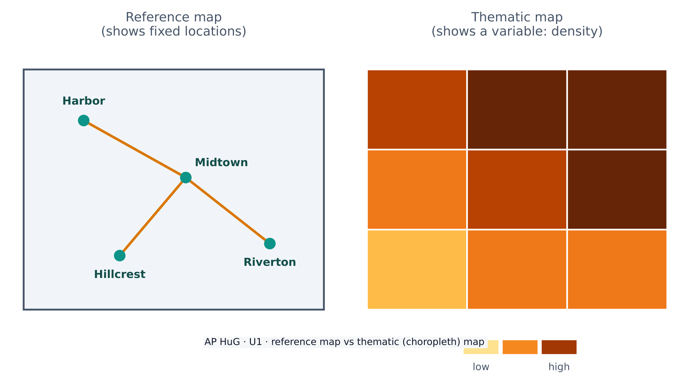
Maps come in two big families. A reference map 参考地图 shows fixed locations — coastlines, borders, roads, cities (a road atlas or Google Maps). A thematic map 专题地图 shows how one variable changes across space — rainfall, income, or population density. AP Human Geography uses thematic maps constantly.

Because Earth is a sphere and a map is flat, every map uses a projection 投影 that stretches the globe onto paper. Projections always distort 扭曲 something — shape, area, distance, or direction. The famous Mercator projection keeps direction correct (useful for sailing) but makes high-latitude places like Greenland look far too large. There is no perfect projection; a cartographer chooses one that fits the map's purpose.

ไทย

ภูมิศาสตร์คือการศึกษาว่าสิ่งต่างๆ อยู่ ที่ไหน และ ทำไม ถึงอยู่ที่นั่นเครื่องมือพื้นฐานที่สุดของมันคือ map — ภาพแบนของพื้นผิวโลกบางส่วน

แผนที่มีสองกลุ่มใหญ่ Reference map แสดงตำแหน่งคงที่ — ชายฝั่ง ขอบเขต ถนน เมือง ( атлас roads หรือ Google Maps) Thematic map แสดง how one variable changes across space — rainfall, income, or population density. AP Human Geography uses thematic maps constantly.

Reference maps show location; thematic maps show how a variable varies over space

เนื่องจากโลกเป็นทรงกลมและแผนที่แบน ทุกแผนที่ใช้ projection ที่ยืดโลกบนกระดาษ Projections always distort something — shape, area, distance, or direction. The famous Mercator projection keeps direction correct (useful for sailing) but makes high-latitude places like Greenland look far too large. There is no perfect projection; a cartographer chooses one that fits the map's purpose.

Vocabulary · ⁨คำศัพท์⁩ Train · ⁨ฝึกฝน⁩
English ไทย
map/mæp/ map
reference map/ˈrefrəns mæp/ แผนที่อ้างอิง
thematic map/θiːˈmætɪk mæp/ แผนที่เฉพาะเรื่อง
projection/prəˈdʒekʃn/ การฉายภาพ
distort/dɪˈstɔːt/ บิดเบี้ยว
1.2

Geographic Data · ⁨ข้อมูลทางภูมิศาสตร์⁩

Syllabus · ⁨หลักสูตร⁩
English

Enduring Understanding (IMP-1): Geographers use maps and data to depict relationships of time, space, and scale.

Learning Objective IMP-1.B: Identify different methods of geographic data collection.

  • IMP-1.B.1 Data may be gathered in the field by organizations or by individuals.
  • IMP-1.B.2 Geospatial technologies include geographic information systems (GIS), satellite navigation systems, remote sensing, and online mapping and visualization.
  • IMP-1.B.3 Spatial information can come from written accounts in the form of field observations, media reports, travel narratives, policy documents, personal interviews, landscape analysis, and photographic interpretation.
ไทย

ความเข้าใจที่ยั่งยืน (IMP-1): นักภูมิศาสตร์ใช้แผนที่และข้อมูลเพื่อแสดงความสัมพันธ์ของเวลา พื้นที่ และสเกล

วัตถุประสงค์การเรียนรู้ IMP-1.B: ระบุวิธีการเก็บรวบรวมข้อมูลทางภูมิศาสตร์ที่แตกต่างกัน

  • IMP-1.B.1 ข้อมูลอาจ đượcเก็บรวบรวมในพื้นที่โดยองค์กรหรือบุคคล
  • IMP-1.B.2 เทคโนโลยีเชิงพื้นที่รวมถึงระบบข้อมูลภูมิศาสตร์ (GIS), ระบบนำทางด้วยดาวเทียม, การรับทราบระยะไกล และการทำแผนที่ออนไลน์และการแสดงผล
  • IMP-1.B.3 ข้อมูลเชิงพื้นที่สามารถมาจากบันทึกข้อความในรูปแบบของการสังเกตในพื้นที่, รายงานสื่อ, บันทึกการเดินทาง, เอกสารนโยบาย, การสัมภาษณ์ส่วนตัว, การวิเคราะห์ภูมิทัศน์ และการตีความภาพถ่าย

Source: College Board AP Course and Exam Description · ⁨แหล่งที่มา: คำอธิบายหลักสูตรและข้อสอบ College Board AP⁩

English

Geographic data 地理数据 is any information tied to a location. Geographers collect it in the field (counting, surveying, interviewing) and remotely with technology.

Key geospatial technologies 地理空间技术 you must know:

  • GIS 地理信息系统 (Geographic Information System) — software that layers many kinds of spatial data so patterns can be compared.
  • GPS (satellite navigation) — pinpoints exact location on Earth.
  • Remote sensing 遥感 — gathers data from satellites or aircraft without touching the ground.

Data also comes from written sources: field observations, media reports, travel writing, policy documents, interviews, and photographs.

ไทย
A dense urban skyline from above: maps and spatial data show how people are distributed on Earth

Geographic data คือข้อมูลใดๆ ที่ผูกกับตำแหน่ง Geographers collect it in the field (counting, surveying, interviewing) and remotely with technology.

Key geospatial technologies you must know:

  • GIS (Geographic Information System) — software that layers many kinds of spatial data so patterns can be compared.
  • GPS (satellite navigation) — pinpoints exact location on Earth.
  • Remote sensing — gathers data from satellites or aircraft without touching the ground.

Data also comes from written sources: field observations, media reports, travel writing, policy documents, interviews, and photographs.

Vocabulary · ⁨คำศัพท์⁩ Train · ⁨ฝึกฝน⁩
English ไทย
Geographic data/ˌdʒɪəˈɡræfɪk ˈdeɪtə/ ข้อมูลภูมิศาสตร์
geospatial technologies/ˌdʒiːəʊˈspeɪʃl tekˈnɒlədʒiz/ เทคโนโลยี geospatial
GIS/ˌdʒiː aɪ ˈes/ ระบบสารสนเทศทางภูมิศาสตร์ (GIS)
Remote sensing/rɪˈməʊt ˈsensɪŋ/ Remote sensing (การสังเกตระยะไกล)
1.3

The Power of Geographic Data · ⁨พลังของข้อมูลทางภูมิศาสตร์⁩

Syllabus · ⁨หลักสูตร⁩
English

Enduring Understanding (IMP-1): Geographers use maps and data to depict relationships of time, space, and scale.

Learning Objective IMP-1.C: Explain the geographical effects of decisions made using geographical information.

  • IMP-1.C.1 Geospatial and geographical data, including census data and satellite imagery, are used at all scales for personal, business and organizational, and governmental decision- making purposes.
ไทย

ความเข้าใจที่ยั่งยืน (IMP-1): นักภูมิศาสตร์ใช้แผนที่และข้อมูลเพื่อแสดงความสัมพันธ์ของเวลา พื้นที่ และสเกล

วัตถุประสงค์การเรียนรู้ IMP-1.C: อธิบายผลกระทบทางภูมิศาสตร์ของการตัดสินใจโดยใช้ข้อมูลทางภูมิศาสตร์

  • IMP-1.C.1 ข้อมูลเชิงพื้นที่และข้อมูลทางภูมิศาสตร์ รวมถึงข้อมูลสำมะโนประชากรและภาพถ่ายดาวเทียม ถูกใช้ในทุกระดับสำหรับการตัดสินใจส่วนบุคคล ธุรกิจ和组织, และการตัดสินใจของรัฐบาล

Source: College Board AP Course and Exam Description · ⁨แหล่งที่มา: คำอธิบายหลักสูตรและข้อสอบ College Board AP⁩

Data is powerful because it drives decisions. Businesses use it to choose store locations, governments use census data to plan schools and roads, and aid agencies use it to send help after a disaster.

But data is never neutral. Who collects it, which categories they use, and how a map is drawn can all shape the message. A map can inform — or it can mislead — so a good geographer always asks where the data came from and what it leaves out.

1.4

Spatial Concepts · ⁨แนวคิดเชิงพื้นที่⁩

Syllabus · ⁨หลักสูตร⁩
English

Enduring Understanding (PSO-1): Geographers analyze relationships among and between places to reveal important spatial patterns.

Learning Objective PSO-1.A: Define major geographic concepts that illustrate spatial relationships.

  • PSO-1.A.1 Spatial concepts include absolute and relative location, space, place, flows, distance decay, time-space compression, and pattern.
ไทย

ความเข้าใจที่ยั่งยืน (PSO-1): นักภูมิศาสตร์วิเคราะห์ความสัมพันธ์ระหว่างและภายในสถานที่เพื่อเปิดเผยรูปแบบเชิงพื้นที่ที่สำคัญ

วัตถุประสงค์การเรียนรู้ PSO-1.A: นิยามแนวคิดทางภูมิศาสตร์หลักที่อธิบายความสัมพันธ์เชิงพื้นที่

  • PSO-1.A.1 แนวคิดเชิงพื้นที่รวมถึงตำแหน่งสัมบูรณ์และสัมพัทธ์ พื้นที่ สถานที่ กระแสการไหล การลดทอนระยะทางตามเวลา-พื้นที่ การบีบอัดเวลา-พื้นที่ และรูปแบบ

Source: College Board AP Course and Exam Description · ⁨แหล่งที่มา: คำอธิบายหลักสูตรและข้อสอบ College Board AP⁩

English
Distance decay

Geographers describe location and pattern with a precise vocabulary.

  • Absolute location 绝对位置 is an exact address — latitude and longitude. Relative location 相对位置 describes a place by what is near it ("north of the river").
  • Absolute distance is measured in kilometres; relative distance is measured in time, cost, or effort.
  • Space–time compression 时空压缩 is the shrinking of the felt distance between places as transport and communication improve.
  • Distance decay 距离衰减 means that interaction between two places weakens as the distance between them grows.

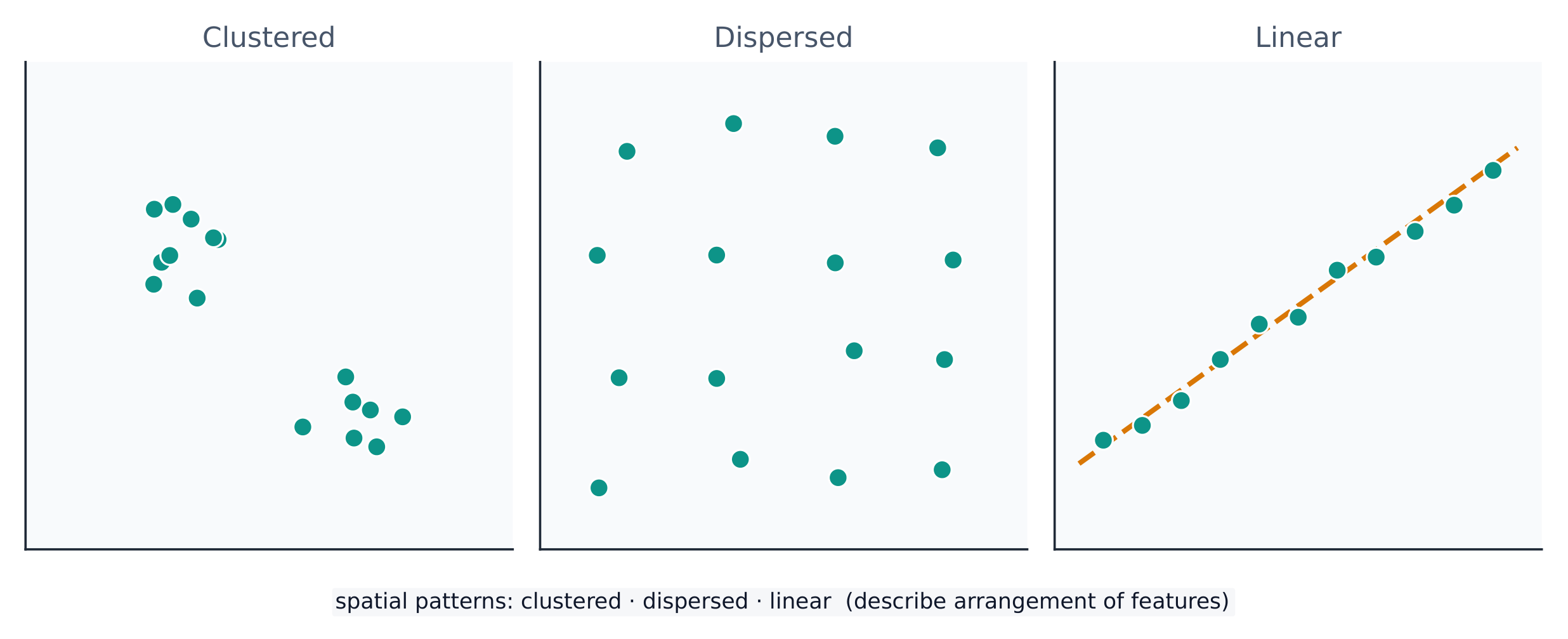
A spatial pattern 空间格局 is how things are arranged: clustered 聚集 (bunched together), dispersed 分散 (spread apart), or linear (along a line such as a road). Reading the pattern is the first step in explaining why it exists.

ไทย
Distance decay

Geographers describe location and pattern with a precise vocabulary.

  • Absolute location is an exact address — latitude and longitude. Relative location describes a place by what is near it ("north of the river").
  • Absolute distance is measured in kilometres; relative distance is measured in time, cost, or effort.
  • Space–time compression is the shrinking of the felt distance between places as transport and communication improve.
  • Distance decay means that interaction between two places weakens as the distance between them grows.
จุดบนพื้นดินสามารถจัดกลุ่ม, กระจายตัว, หรือเรียงตามเส้นตรง
จุดสามารถจัดกลุ่ม, กระจายตัว, หรือเรียงตามเส้นตรง — รูปแบบพื้นที่เป็นข้อมูลในตัวเอง

รูปแบบพื้นที่ คือการจัดวางสิ่งต่างๆ: แบบกลุ่ม (รวมกันอยู่), แบบกระจาย (แยกห่างกัน), หรือ แบบเส้นตรง (ตามเส้นเช่นถนน) การอ่านรูปแบบนี้เป็นขั้นตอนแรกในการอธิบาย ทำไม รูปแบบถึงเกิดขึ้น

Vocabulary · ⁨คำศัพท์⁩ Train · ⁨ฝึกฝน⁩
English ไทย
Absolute location/ˈæbsəluːt ləʊˈkeɪʃn/ ตำแหน่งสัมบูรณ์
Relative location/ˈrelətɪv ləʊˈkeɪʃn/ ตำแหน่งสัมพัทธ์
Space–time compression/speɪs taɪm kəmˈpreʃn/ Time-space compression
Distance decay/ˈdɪstəns dɪˈkeɪ/ การลดทอนระยะทาง
spatial pattern/ˈspeɪʃl ˈpætn/ pattern Spatial
clustered/ˈklʌstəd/ รวมกลุ่ม
dispersed/dɪˈspɜːst/ กระจาย
Environmental determinism/enˌvaɪrənˈmentl dɪˈtɜːmɪnɪzəm/ Ẳtism
Watch lesson · ⁨ดูบทเรียน⁩
1.5

Human-Environmental Interaction · ⁨การมีปฏิสัมพันธ์ระหว่างมนุษย์กับสิ่งแวดล้อม⁩

Syllabus · ⁨หลักสูตร⁩
English

Enduring Understanding (PSO-1): Geographers analyze relationships among and between places to reveal important spatial patterns.

Learning Objective PSO-1.B: Explain how major geographic concepts illustrate spatial relationships.

  • PSO-1.B.1 Concepts of nature and society include sustainability, natural resources, and land use.
  • PSO-1.B.2 Theories regarding the interaction of the natural environment with human societies have evolved from environmental determinism to possibilism.
ไทย

ความเข้าใจที่ยั่งยืน (PSO-1): นักภูมิศาสตร์วิเคราะห์ความสัมพันธ์ระหว่างและภายในสถานที่เพื่อเปิดเผยรูปแบบเชิงพื้นที่ที่สำคัญ

วัตถุประสงค์การเรียนรู้ PSO-1.B: อธิบายว่าแนวคิดทางภูมิศาสตร์หลักอธิบายความสัมพันธ์เชิงพื้นที่อย่างไร

  • PSO-1.B.1 แนวคิดเกี่ยวกับธรรมชาติและสังคมรวมถึงความยั่งยืน ทรัพยากรธรรมชาติ และการใช้ที่ดิน
  • PSO-1.B.2 ทฤษฎีเกี่ยวกับการปฏิสัมพันธ์ระหว่างสิ่งแวดล้อมทางธรรมชาติกับสังคมมนุษย์ได้พัฒนาจากẲ environmental determinism ไปสู่ possibilism

Source: College Board AP Course and Exam Description · ⁨แหล่งที่มา: คำอธิบายหลักสูตรและข้อสอบ College Board AP⁩

English

People and the environment shape each other. Three older ideas describe this:

  • Environmental determinism 环境决定论 — the (now rejected) claim that the physical environment determines how a culture develops.
  • Possibilism 可能论 — the accepted view that the environment sets limits, but people choose how to respond using technology and culture.

The cultural landscape 文化景观 — farms, cities, and roads built on the land — is the visible result of this interaction. Sustainability asks how people can use natural resources without using them up.

ไทย
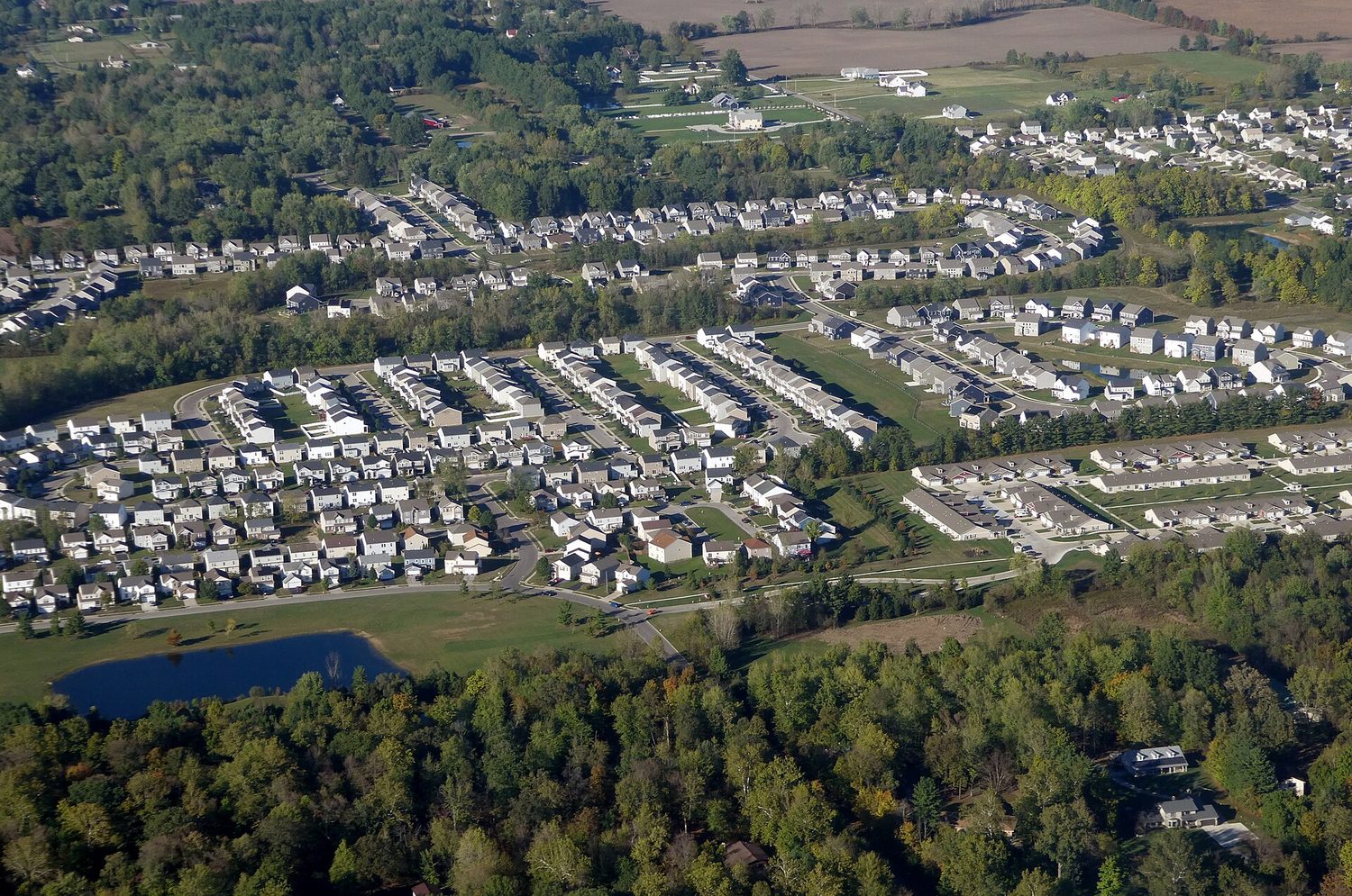
การขยายตัวของเมืองที่ขอบเขตเมือง: การมีปฏิสัมพันธ์ระหว่างมนุษย์กับสิ่งแวดล้อมเปลี่ยนแปลงภูมิประเทศ

มนุษย์และสิ่งแวดล้อมสร้างอิทธิพลต่อกันและกัน มีแนวคิดเก่าแก่สามประการที่อธิบายเรื่องนี้:

  • Ẕẅẍẃẋẉẑẙẗẘẏẖẓẋ — locator (ซึ่งถูกปฏิเสธในปัจจุบัน) ที่อ้างว่าสิ่งแวดล้อมทางกายภาพ กำหนด การพัฒนาของวัฒนธรรม
  • Possibilism — มุมมองที่ยอมรับกันว่าสิ่งแวดล้อมกำหนดขอบเขต แต่คน เลือก วิธีตอบสนองโดยใช้เทคโนโลยีและวัฒนธรรม

ภูมิทัศน์ทางวัฒนธรรม — ไร่ทำนา เมือง และถนนที่สร้างขึ้นบนแผ่นดิน — เป็นผลลัพธ์ที่มองเห็นได้ของการมีปฏิสัมพันธ์นี้ ความยั่งยืนตั้งคำถามว่าผู้คนสามารถใช้ทรัพยากรธรรมชาติโดยไม่ใช้จนหมดสิ้นได้อย่างไร

Vocabulary · ⁨คำศัพท์⁩ Train · ⁨ฝึกฝน⁩
English ไทย
Possibilism/ˈpɒsɪbɪlɪzəm/ Possibilism
cultural landscape/ˈkʌltʃərəl ˈlændskeɪp/ ภูมิทัศน์ทางวัฒนธรรม (Cultural landscape)
Scale of analysis/skeɪl ɒv əˈnæləsɪs/ Scale of analysis
1.6

Scales of Analysis · ⁨ขอบเขตของการวิเคราะห์⁩

Syllabus · ⁨หลักสูตร⁩
English

Enduring Understanding (PSO-1): Geographers analyze relationships among and between places to reveal important spatial patterns.

Learning Objective PSO-1.C: Define scales of analysis used by geographers.

  • PSO-1.C.1 Scales of analysis include global, regional, national, and local.

Learning Objective PSO-1.D: Explain what scales of analysis reveal.

  • PSO-1.D.1 Patterns and processes at different scales reveal variations in, and different interpretations of, data.
ไทย

ความเข้าใจที่ยั่งยืน (PSO-1): นักภูมิศาสตร์วิเคราะห์ความสัมพันธ์ระหว่างและภายในสถานที่เพื่อเปิดเผยรูปแบบเชิงพื้นที่ที่สำคัญ

วัตถุประสงค์การเรียนรู้ PSO-1.C: นิยามสเกลของการวิเคราะห์ที่ใช้โดยนักภูมิศาสตร์

  • PSO-1.C.1 สเกลของการวิเคราะห์รวมถึงระดับโลก ระดับภูมิภาค ระดับชาติ และระดับท้องถิ่น

วัตถุประสงค์การเรียนรู้ PSO-1.D: อธิบายสิ่งที่สเกลของการวิเคราะห์เปิดเผย

  • PSO-1.D.1 รูปแบบและกระบวนการในระดับต่างๆ แสดงถึงความแตกต่างในการตีความข้อมูล

Source: College Board AP Course and Exam Description · ⁨แหล่งที่มา: คำอธิบายหลักสูตรและข้อสอบ College Board AP⁩

English

Scale of analysis 分析尺度 is the level at which you look at data — global, regional, national, or local. The same pattern can look completely different at different scales.

For example, a country may look wealthy at the national scale, yet contain very poor neighbourhoods at the local scale. Zooming in or out — changing the scale — reveals patterns that were hidden before. Exam questions often ask you to explain a process "at various scales."

Worked example (a real AP exam question). "The map focuses on a regional scale. Explain a possible limitation of drawing country-scale conclusions from a regional-scale map." (2025) A full-mark answer: "The map shows only one region, so its pattern may not represent the whole country — other regions could look very different, so a conclusion drawn at the regional scale would be inaccurate at the country scale." The command word Explain asks for reasoning: state the limitation and say why changing the scale changes the pattern. Just writing "the scales are different" does not earn the mark.

ไทย

ขอบเขตของการวิเคราะห์ คือระดับที่คุณดูข้อมูล — ระดับโลก, ระดับภูมิภาค, ระดับชาติ, หรือระดับท้องถิ่น รูปแบบเดียวกันอาจดูแตกต่างกันอย่างสิ้นเชิงในระดับที่แตกต่างกัน

รูปแบบซ้อนทับกัน across scales: global, regional, national, and local
สถานที่เดียวกันซ้อนอยู่ในขอบเขตที่ใหญ่ขึ้นเรื่อยๆ — ขอบเขตที่คุณเลือกจะเปลี่ยนรูปแบบที่คุณเห็น

ตัวอย่างเช่น ประเทศอาจดูมั่งคั่งในระดับ แห่งชาติ แต่อาจมีชุมชนยากจนมากในระดับ ท้องถิ่น การซูมเข้าหรือออก — การเปลี่ยนขอบเขต — เผยรูปแบบที่ซ่อนอยู่มาก่อน ข้อสอบมักถามให้คุณอธิบายกระบวนการ "ในระดับต่างๆ"

ตัวอย่างวิธีทำ (ข้อสอบ AP จริง) "แผนที่เน้นที่ระดับภูมิภาค อธิบายข้อจำกัดที่เป็นไปได้ของการสรุปผลในระดับประเทศจากแผนที่ระดับภูมิภาค" (2025) คำตอบเต็มคะแนน: "แผนที่แสดงเพียงภูมิภาคเดียว ดังนั้นรูปแบบของมันอาจไม่แทนทั้งประเทศ — ภูมิภาคอื่นอาจดูต่างกันมาก ดังนั้นการสรุปผลในระดับภูมิภาคจึงไม่ถูกต้องในระดับประเทศ" คำสั่ง Explain ต้องการเหตุผล: ระบุข้อจำกัด และ บอกว่าทำไมการเปลี่ยนขอบเขตจึงเปลี่ยนรูปแบบ การเขียนแค่ว่า "ขอบเขตต่างกัน" ไม่ได้คะแนน

Vocabulary · ⁨คำศัพท์⁩ Train · ⁨ฝึกฝน⁩
English ไทย
region/ˈriːdʒn/ ภูมิภาค (Region)
Formal (uniform) region/ˈfɔːml ˈriːdʒn/ พื้นที่ทางการ (พื้นที่สม่ำเสมอ)
Functional (nodal) region/ˈfʌŋkʃənl ˈriːdʒn/ พื้นที่เชิงฟังก์ชัน (พื้นที่แกน)
Perceptual (vernacular) region/pəˈseptʃuːəl ˈriːdʒn/ พื้นที่การรับรู้ (พื้นที่ท้องถิ่น)
1.7

Regional Analysis · ⁨การวิเคราะห์ระดับภูมิภาค⁩

Syllabus · ⁨หลักสูตร⁩
English

Enduring Understanding (SPS-1): Geographers analyze complex issues and relationships with a distinctively spatial perspective.

Learning Objective SPS-1.A: Describe different ways that geographers define regions.

  • SPS-1.A.1 Regions are defined on the basis of one or more unifying characteristics or on patterns of activity.
  • SPS-1.A.2 Types of regions include formal, functional, and perceptual/vernacular.
  • SPS-1.A.3 Regional boundaries are transitional and often contested and overlapping.
  • SPS-1.A.4 Geographers apply regional analysis at local, national, and global scales.
ไทย

ความเข้าใจที่ยั่งยืน (SPS-1): นักภูมิศาสตร์วิเคราะห์ปัญหาซับซ้อนและความสัมพันธ์ด้วยมุมมองเชิงพื้นที่ที่เป็นเอกลักษณ์

วัตถุประสงค์การเรียนรู้ SPS-1.A: อธิบายวิธีการต่างๆ ที่นักภูมิศาสตร์ใช้กำหนดภูมิภาค

  • SPS-1.A.1 ภูมิภาคถูกกำหนดโดยลักษณะร่วมหนึ่งหรือมากกว่า หรือโดยรูปแบบกิจกรรม
  • SPS-1.A.2 ประเภทของภูมิภาครวมถึงแบบทางการ แบบฟังก์ชัน และแบบรับรู้/ภาษาถิ่น
  • SPS-1.A.3 ขอบเขตภูมิภาคเป็นการเปลี่ยนแปลงและมักถูก tranh cãiและทับซ้อนกัน
  • SPS-1.A.4 นักภูมิศาสตร์ประยุกต์ใช้การวิเคราะห์ภูมิภาคในระดับท้องถิ่น ระดับชาติ และระดับโลก

Source: College Board AP Course and Exam Description · ⁨แหล่งที่มา: คำอธิบายหลักสูตรและข้อสอบ College Board AP⁩

English

A region 区域 is an area with one or more shared features that make it different from surrounding areas. Geographers use three types:

  • Formal (uniform) region 均质区域 — everyone shares a measurable trait (a country, a wheat-growing belt, a language area).
  • Functional (nodal) region 功能区域 — organised around a central node, like a city and its commuter zone or a pizza shop's delivery area.
  • Perceptual (vernacular) region 感知区域 — defined by people's feelings and beliefs, with fuzzy borders (the "American South", the "Middle East").

Regions are made by geographers, not found in nature — so their borders can be argued about, which is exactly why they are useful for analysis.

ไทย

ภูมิภาค คือพื้นที่ที่มีลักษณะร่วมหนึ่งหรือมากกว่าที่ทำให้แตกต่างจากพื้นที่รอบข้าง นักภูมิศาสตร์ใช้สามประเภท:

  • ภูมิภาคแบบรูปธรรม (Formal/Uniform region) — ทุกคนมีคุณสมบัติวัดได้ร่วมกัน (ประเทศ, เขตปลูกสาลี, พื้นที่ภาษา)
  • ภูมิภาคแบบฟังก์ชัน (Functional/Nodal region) — จัดระเบียบรอบ โหนด กลาง เช่น เมืองและเขตผู้เดินทางมาทำงาน หรือพื้นที่จัดส่งของร้านพิซซ่า
  • ภูมิภาคแบบรับรู้ (Perceptual/Vernacular region) — กำหนดโดยความรู้สึกและความเชื่อของคน มีขอบเขตที่ไม่ชัดเจน ("ภาคใต้ของอเมริกา", "ตะวันออกกลาง")

ภูมิภาคถูกสร้างโดยนักภูมิศาสตร์ ไม่ใช่พบในธรรมชาติ — ดังนั้นขอบเขตของมันจึงสามารถถกเถียงกันได้ ซึ่งนี่คือเหตุผลที่มันมีประโยชน์สำหรับการวิเคราะห์

Explore · ⁨สำรวจ⁩

Sort each example into the right kind of region · ⁨จำแนกตัวอย่างแต่ละข้อลงในประเภทของภูมิภาคที่เหมาะสม⁩

A formal region shares one measured trait, a functional region is organised around a node, and a perceptual region is defined by people's feelings. · ⁨ภูมิภาคแบบ ทางการ มีลักษณะวัดค่าได้เพียงอย่างหนึ่ง ภูมิภาคแบบ เชิงฟังก์ชัน จัดตั้งขึ้นรอบๆ จุดศูนย์กลาง และภูมิภาคแบบ รับรู้ ถูกกำหนดด้วยความรู้สึกของผู้คน⁩

1.7

Exam tips · ⁨ข้อแนะนำสำหรับการสอบ⁩

English
  • Always name a map projection's trade-off: what it preserves versus distorts (Mercator keeps direction but exaggerates area).
  • State whether data is quantitative or qualitative, and match a source (GIS, GPS, remote sensing, census) to its use.
  • Distinguish absolute from relative location, and use distance decay and time-space compression in any flow answer.
  • Mind the scale of analysis: a national average hides local variation — say so explicitly.
  • Classify every region as formal, functional, or perceptual, and justify it by the defining trait.
ไทย
  • ระบุเสมอ关于 projection ของแผนที่: ข้อดีเสีย: มันรักษาอะไรไว้ vs บิดเบี้ยวอะไร (Mercator รักษาทิศทางแต่ melebihขนาดพื้นที่)
  • ระบุว่าข้อมูลเป็น ปริมาณ (quantitative) หรือ คุณภาพ (qualitative) และจับคู่แหล่งที่มา (GIS, GPS, remote sensing, สำมะโนประชากร) กับการใช้งาน
  • แยกแยะ ตำแหน่งสัมบูรณ์ จาก ตำแหน่งสัมพัทธ์ และใช้ distance decay และ time-space compression ในคำตอบเกี่ยวกับกระแสการไหล
  • ระวัง ขอบเขตของการวิเคราะห์: ค่าเฉลี่ยระดับชาติบดบังความแปรปรวนระดับท้องถิ่น — ต้องระบุให้ชัดเจน
  • จัดประเภททุกภูมิภาคว่าเป็น formal, functional, หรือ perceptual และให้เหตุผลโดยคุณลักษณะที่กำหนด

Interactive lessons on this topic · ⁨บทเรียนเชิงโต้ตอบสำหรับหัวข้อนี้⁩

Work through it step by step, with instant-check exercises. · ⁨ทำทีละขั้นตอน พร้อมแบบฝึกหัดตรวจสอบผลทันที⁩

Past Papers · ⁨ข้อสอบย้อนหลัง⁩

More topics in AP Human Geography · ⁨AP ภูมิศาสตร์มนุษย์⁩ · ⁨หัวข้อเพิ่มเติมใน AP Human Geography · ⁨AP ภูมิศาสตร์มนุษย์⁩⁩

Log in or create account · ⁨เข้าสู่ระบบหรือสร้างบัญชี⁩

IGCSE, A-Level & AP