Skip to content · ⁨コンテンツへスキップ⁩

Thinking Geographically · ⁨地理的思考⁩

AP Human Geography · ⁨AP 人文地理学⁩ · Topic 1 · ⁨トピック 1⁩

View Slides · ⁨查看幻灯片⁩ Train · ⁨練習する⁩
Video lesson for this topic · ⁨このトピックのビデオレッスン⁩ Open the video page · ⁨動画ページを開く⁩
8:14

地理的思考

教室の世界地図の上でグリーンランドを見てみよ。アフリカと同じ大きさに見えるかもしれない。しかし実際には違う。アフリカは14倍大きい。<slow>地図はあなたを騙してはいない…

English narration · English + 中文 subtitles burned in · ⁨英語ナレーション・英語+中文字幕 burning-in⁩

1.1

Introduction to Maps · ⁨マップ入門⁩

Syllabus · ⁨シラバス⁩
English

Enduring Understanding (IMP-1): Geographers use maps and data to depict relationships of time, space, and scale.

Learning Objective IMP-1.A: Identify types of maps, the types of information presented in maps, and different kinds of spatial patterns and relationships portrayed in maps.

  • IMP-1.A.1 Types of maps include reference maps and thematic maps.
  • IMP-1.A.2 Types of spatial patterns represented on maps include absolute and relative distance and direction, clustering, dispersal, and elevation.
  • IMP-1.A.3 All maps are selective in information; map projections inevitably distort spatial relationships in shape, area, distance, and direction.
日本語

持続的理解 (IMP-1): 地理学者は、時間、空間、スケールの関係性を表現するためにマップやデータを使用する。

学習目標 IMP-1.A: マップの種類、マップに提示される情報の種類、およびマップに描かれる異なる空間パターンと関係を特定する。

  • IMP-1.A.1 マップの種類には、参照マップと主題マップが含まれる。
  • IMP-1.A.2 マップに表される空間パターンの種類には、絶対距離と相対距離および方向、集積、分散、標高が含まれる。
  • IMP-1.A.3 すべてのマップは情報選択的に作成されており、マップ投影法は必然的に形状、面積、距離、方向における空間的関係を歪曲させる。
Source: College Board AP Course and Exam Description · ⁨出典: College Board AP コースおよび試験説明書⁩

English

Geography is the study of where things are and why they are there. Its most basic tool is the map 地图 — a flattened picture of some part of Earth's surface.

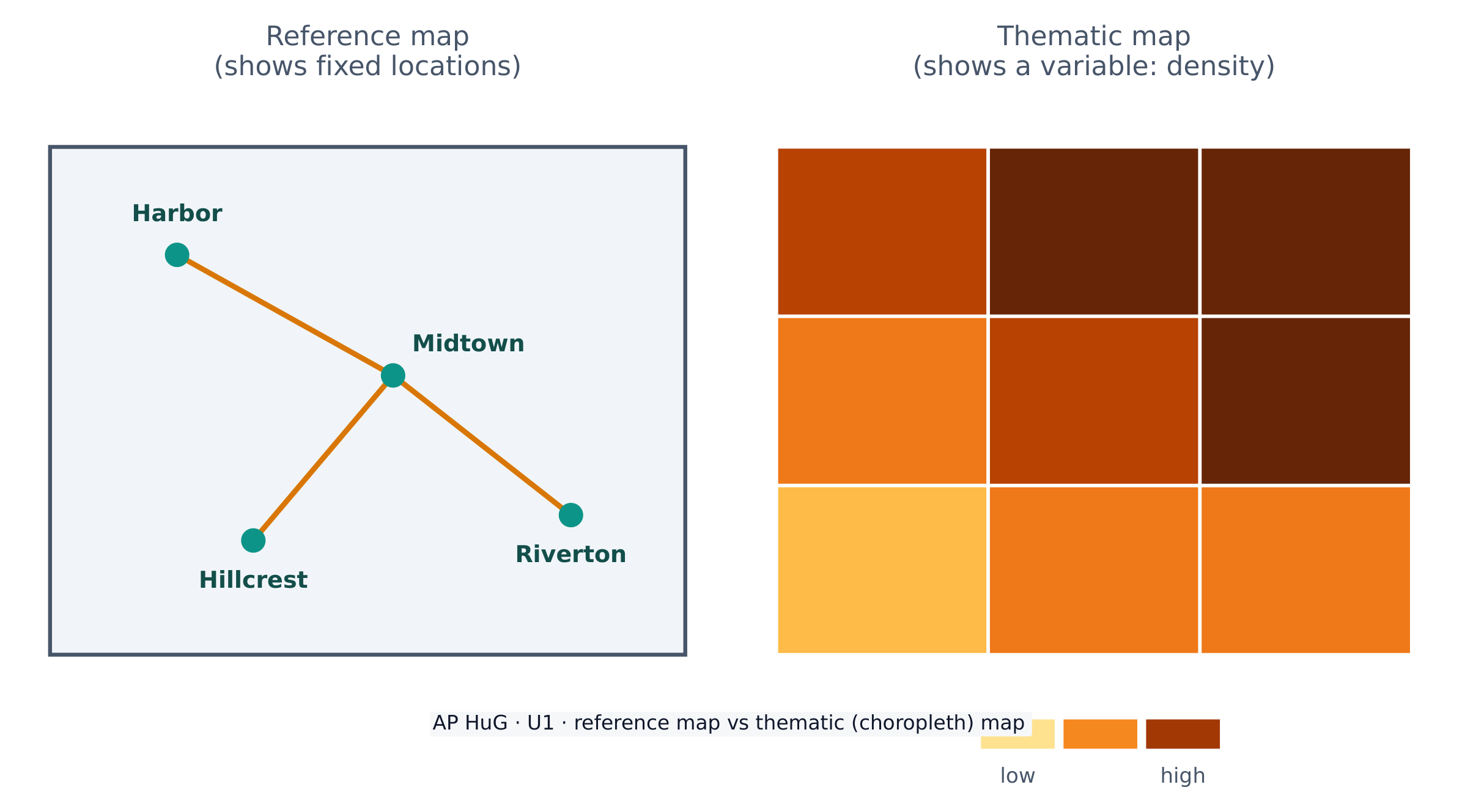
Maps come in two big families. A reference map 参考地图 shows fixed locations — coastlines, borders, roads, cities (a road atlas or Google Maps). A thematic map 专题地图 shows how one variable changes across space — rainfall, income, or population density. AP Human Geography uses thematic maps constantly.

Because Earth is a sphere and a map is flat, every map uses a projection 投影 that stretches the globe onto paper. Projections always distort 扭曲 something — shape, area, distance, or direction. The famous Mercator projection keeps direction correct (useful for sailing) but makes high-latitude places like Greenland look far too large. There is no perfect projection; a cartographer chooses one that fits the map's purpose.

日本語

地理学とは、事物がどこにあるか、そしてなぜそこにあるかを研究する学問である。その最も基本的な道具は地図——地球表面の一部を平面化した図像である。

地図は大きく2つのファミリーに分かれる。参照地図は固定された場所——海岸線、国境、道路、都市——を示す(道路 atlas や Google Maps など)。テーママップ(主題図) は、空間全体で変数がどのように変化するか——降水量、所得、人口密度など——を示す。AP地理学ではテーママップを頻繁に用いる。

参照地図は位置を示し、主題地図は変数が空間的にどのように変動するかを示す

地球は球体である一方、地図は平面的であるため、すべての地図は地球紙面に広げるための投影法を用いている。投影法は必ず何かを歪曲させる——形状、面積、距離、あるいは方向である。有名なメルカトル投影法は方向を正確に保つ(航海に有用)が、グリーンランドのような高緯度地方を非常に大きく見せてしまう。完璧な投影法はなく、製図者は地図の目的に適したものを選ぶ。

Vocabulary · ⁨語彙⁩ Train · ⁨練習する⁩
English 日本語
map/mæp/ 地図
reference map/ˈrefrəns mæp/ 参照地図
thematic map/θiːˈmætɪk mæp/ 主題地図
projection/prəˈdʒekʃn/ 投影法
distort/dɪˈstɔːt/ 歪める
Geographic data/ˌdʒɪəˈɡræfɪk ˈdeɪtə/ 地理データ
geospatial technologies/ˌdʒiːəʊˈspeɪʃl tekˈnɒlədʒiz/ 地理空間技術
1.2

Geographic Data · ⁨地理データ⁩

Syllabus · ⁨シラバス⁩
English

Enduring Understanding (IMP-1): Geographers use maps and data to depict relationships of time, space, and scale.

Learning Objective IMP-1.B: Identify different methods of geographic data collection.

  • IMP-1.B.1 Data may be gathered in the field by organizations or by individuals.
  • IMP-1.B.2 Geospatial technologies include geographic information systems (GIS), satellite navigation systems, remote sensing, and online mapping and visualization.
  • IMP-1.B.3 Spatial information can come from written accounts in the form of field observations, media reports, travel narratives, policy documents, personal interviews, landscape analysis, and photographic interpretation.
日本語

持続的理解 (IMP-1): 地理学者は、時間、空間、スケールの関係性を表現するためにマップやデータを使用する。

学習目標 IMP-1.B: 地理データの収集方法の違いを特定する。

  • IMP-1.B.1 データは、組織または個人によって野外で収集されることがある。
  • IMP-1.B.2 地理空間技術には、地理情報システム(GIS)、衛星位置決めシステム、リモートセンシング、オンラインマップおよび可視化が含まれる。
  • IMP-1.B.3 空間情報は、野外観察、メディア報告、旅行記、政策文書、個人インタビュー、景観分析、写真解釈といった形式的な記録から得られることがある。

Source: College Board AP Course and Exam Description · ⁨出典: College Board AP コースおよび試験説明書⁩

English

Geographic data 地理数据 is any information tied to a location. Geographers collect it in the field (counting, surveying, interviewing) and remotely with technology.

Key geospatial technologies 地理空间技术 you must know:

  • GIS 地理信息系统 (Geographic Information System) — software that layers many kinds of spatial data so patterns can be compared.
  • GPS (satellite navigation) — pinpoints exact location on Earth.
  • Remote sensing 遥感 — gathers data from satellites or aircraft without touching the ground.

Data also comes from written sources: field observations, media reports, travel writing, policy documents, interviews, and photographs.

日本語
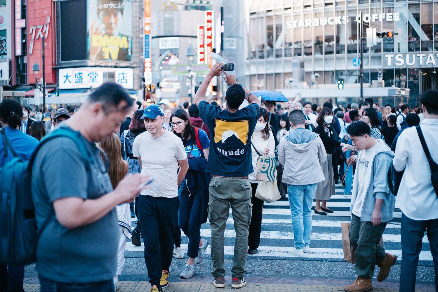
上空から見た密集した都市のスカイライン:地図と空間データは人々が地球上にどのように分布しているかを示す

地理データとは、特定の場所に結びつけられたあらゆる情報を指す。地理学者は野外調査(計測、測量、インタビュー)と、技術を用いた遠隔収集の両方でこれを収集する。

知っておくべき主要な地理情報技術:

  • GIS(Geographic Information System)— 多様な種類の空間データを重ね合わせるソフトウェアで、パターンを比較可能にする。
  • GPS(衛星ナビゲーション)— 地球上の正確な位置を特定する。
  • リモートセンシング— 地上に触れることなく、衛星や航空機からデータを収集する。

データはまた、書かれた資料からも得られる:現地での観察、メディア報道、旅行記、政策文書、インタビュー、写真など。

Vocabulary · ⁨語彙⁩ Train · ⁨練習する⁩
English 日本語
GIS/ˌdʒiː aɪ ˈes/ GIS
Remote sensing/rɪˈməʊt ˈsensɪŋ/ リモートセンシング
Absolute location/ˈæbsəluːt ləʊˈkeɪʃn/ 絶対位置
Relative location/ˈrelətɪv ləʊˈkeɪʃn/ 相対位置
Space–time compression/speɪs taɪm kəmˈpreʃn/ 時空圧縮
1.3

The Power of Geographic Data · ⁨地理データの力⁩

Syllabus · ⁨シラバス⁩
English

Enduring Understanding (IMP-1): Geographers use maps and data to depict relationships of time, space, and scale.

Learning Objective IMP-1.C: Explain the geographical effects of decisions made using geographical information.

  • IMP-1.C.1 Geospatial and geographical data, including census data and satellite imagery, are used at all scales for personal, business and organizational, and governmental decision- making purposes.
日本語

持続的理解 (IMP-1): 地理学者は、時間、空間、スケールの関係性を表現するためにマップやデータを使用する。

学習目標 IMP-1.C: 地理情報を用いて行われた意思決定がもたらす地理的影響について説明する。

  • IMP-1.C.1 国勢調査データや衛星画像を含む地理空間および地理データは、個人、ビジネスおよび組織、政府の意思決定のためにあらゆるスケールで用いられる。

Source: College Board AP Course and Exam Description · ⁨出典: College Board AP コースおよび試験説明書⁩

English

Data is powerful because it drives decisions. Businesses use it to choose store locations, governments use census data to plan schools and roads, and aid agencies use it to send help after a disaster.

But data is never neutral. Who collects it, which categories they use, and how a map is drawn can all shape the message. A map can inform — or it can mislead — so a good geographer always asks where the data came from and what it leaves out.

日本語

データは強力である。なぜなら、それは意思決定を促すからである。企業は店舗の立地選択に利用し、政府は国勢調査データを用いて学校や道路を計画し、援助機関は災害後に支援を送るために用它する。

しかしデータは決して中立ではない。誰が収集し、どのようなカテゴリを使用し、どうやって描くかがすべてメッセージを形作る。地図は情報提供にもなるが、誤解を招くこともあるため、良い地理学者は常にデータの由来と除外された要素について問いかける。

1.4

Spatial Concepts · ⁨空間概念⁩

Syllabus · ⁨シラバス⁩
English

Enduring Understanding (PSO-1): Geographers analyze relationships among and between places to reveal important spatial patterns.

Learning Objective PSO-1.A: Define major geographic concepts that illustrate spatial relationships.

  • PSO-1.A.1 Spatial concepts include absolute and relative location, space, place, flows, distance decay, time-space compression, and pattern.
日本語

持続的理解 (PSO-1): 地理学者は、場所間の関係性を分析して重要な空間パターンを明らかにする。

学習目標 PSO-1.A: 空間的関係を示す主要な地理的概念を定義する。

  • PSO-1.A.1 空間的概念には、絶対位置と相対位置、空間、場所、流れ、距離減衰、時空間圧縮、パターンが含まれる。

Source: College Board AP Course and Exam Description · ⁨出典: College Board AP コースおよび試験説明書⁩

English
Distance decay

Geographers describe location and pattern with a precise vocabulary.

  • Absolute location 绝对位置 is an exact address — latitude and longitude. Relative location 相对位置 describes a place by what is near it ("north of the river").
  • Absolute distance is measured in kilometres; relative distance is measured in time, cost, or effort.
  • Space–time compression 时空压缩 is the shrinking of the felt distance between places as transport and communication improve.
  • Distance decay 距离衰减 means that interaction between two places weakens as the distance between them grows.

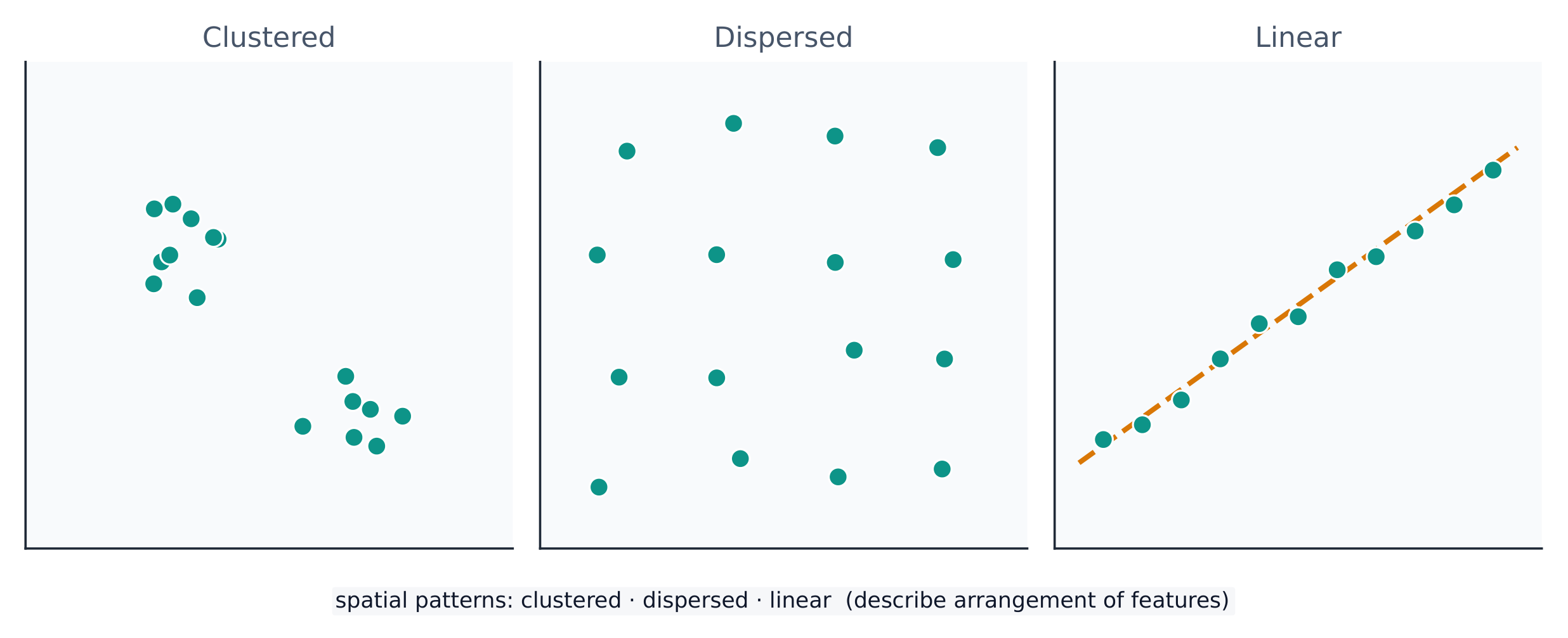
A spatial pattern 空间格局 is how things are arranged: clustered 聚集 (bunched together), dispersed 分散 (spread apart), or linear (along a line such as a road). Reading the pattern is the first step in explaining why it exists.

日本語
距離減衰

地理学者は位置とパターンを精密な用語で記述する。

  • 絶対位置とは正確な住所(経度と緯度)を指す。相対位置とは、近接する事物によって場所を説明すること(例:「川の北側」)。
  • 絶対距離はキロメートルで測定され、相対距離は時間、費用、または努力度合いで測定される。
  • 時空間圧縮とは、交通・通信の改善に伴い、場所間の「感じる距離」が縮小することを指す。
  • 距離減衰とは、二つの場所間の距離が大きくなるにつれて、相互の相互作用が弱まることを意味する。
陸上の点は、集積、分散、または線状に配置されている
点は集積し、分散したり、線状に配置されたりする——空間パターンそのものがデータである

空間パターンとは、物がどのように配置されているかを示すものであり、集積(塊になっている)、分散(ばらばらになっている)、または線状(道路などの線に沿っている)のいずれかである。パターンの読み取りは、それがなぜ存在するのかを説明するための第一歩である。

Vocabulary · ⁨語彙⁩ Train · ⁨練習する⁩
English 日本語
Distance decay/ˈdɪstəns dɪˈkeɪ/ 距離減衰
spatial pattern/ˈspeɪʃl ˈpætn/ 空間パターン
clustered/ˈklʌstəd/ 集約された
dispersed/dɪˈspɜːst/ 分散型
Environmental determinism/enˌvaɪrənˈmentl dɪˈtɜːmɪnɪzəm/ 環境決定論
Possibilism/ˈpɒsɪbɪlɪzəm/ 可能性論
cultural landscape/ˈkʌltʃərəl ˈlændskeɪp/ 文化的景観 (cultural landscape)
Scale of analysis/skeɪl ɒv əˈnæləsɪs/ 分析のスケール
region/ˈriːdʒn/ 地域 (region)
Formal (uniform) region/ˈfɔːml ˈriːdʒn/ 形式地域(均質地域)
Functional (nodal) region/ˈfʌŋkʃənl ˈriːdʒn/ 機能地域(核地域)
Perceptual (vernacular) region/pəˈseptʃuːəl ˈriːdʒn/ 知覚地域(俗語的地域)
Watch lesson · ⁨レッスンを視聴⁩
1.5

Human-Environmental Interaction · ⁨人間と環境の相互作用⁩

Syllabus · ⁨シラバス⁩
English

Enduring Understanding (PSO-1): Geographers analyze relationships among and between places to reveal important spatial patterns.

Learning Objective PSO-1.B: Explain how major geographic concepts illustrate spatial relationships.

  • PSO-1.B.1 Concepts of nature and society include sustainability, natural resources, and land use.
  • PSO-1.B.2 Theories regarding the interaction of the natural environment with human societies have evolved from environmental determinism to possibilism.
日本語

持続的理解 (PSO-1): 地理学者は、場所間の関係性を分析して重要な空間パターンを明らかにする。

学習目標 PSO-1.B: 主要な地理的概念が空間的関係を示す方法を説明する。

  • PSO-1.B.1 自然と社会の概念には、持続可能性、天然資源、土地利用が含まれる。
  • PSO-1.B.2 自然環境と人類社会の相互作用に関する理論は、環境決定論から可能主義へと発展してきた。

Source: College Board AP Course and Exam Description · ⁨出典: College Board AP コースおよび試験説明書⁩

English

People and the environment shape each other. Three older ideas describe this:

  • Environmental determinism 环境决定论 — the (now rejected) claim that the physical environment determines how a culture develops.
  • Possibilism 可能论 — the accepted view that the environment sets limits, but people choose how to respond using technology and culture.

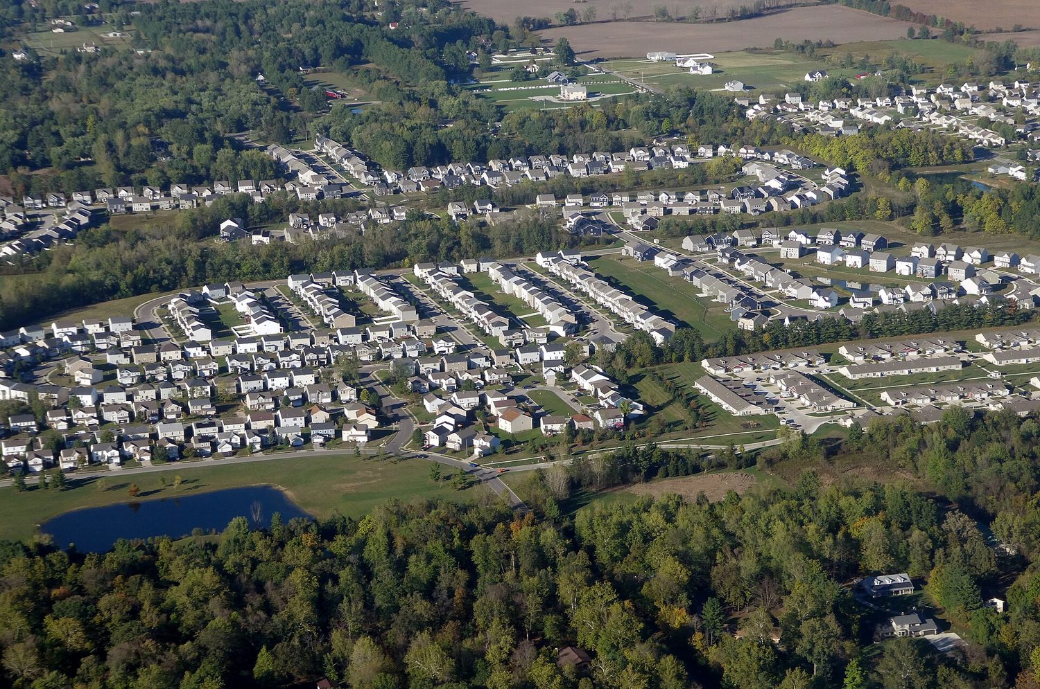
The cultural landscape 文化景观 — farms, cities, and roads built on the land — is the visible result of this interaction. Sustainability asks how people can use natural resources without using them up.

日本語
都市端部におけるスプロール化:人間と環境の相互作用が景観を変化させる

人々と環境は互いに影響し合い、形作っている。これを説明する古い考え方に3つある:

  • 環境決定説——物理的な環境が文化の発展を「決定」するという(現在では否定された)主張。
  • 可能性論——環境が限界を設定するが、人々は技術や文化を用いてどう対応するかを選択できるとされる、現在の主流の見解。

文化的景観——土地の上に築かれた農場、都市、道路など——は、この相互作用の視覚的な結果である。持続可能性とは、人々が自然資源を使い果たすことなく利用する方法について問うものである。

1.6

Scales of Analysis · ⁨分析スケール⁩

Syllabus · ⁨シラバス⁩
English

Enduring Understanding (PSO-1): Geographers analyze relationships among and between places to reveal important spatial patterns.

Learning Objective PSO-1.C: Define scales of analysis used by geographers.

  • PSO-1.C.1 Scales of analysis include global, regional, national, and local.

Learning Objective PSO-1.D: Explain what scales of analysis reveal.

  • PSO-1.D.1 Patterns and processes at different scales reveal variations in, and different interpretations of, data.
日本語

持続的理解 (PSO-1): 地理学者は、場所間の関係性を分析して重要な空間パターンを明らかにする。

学習目標 PSO-1.C: 地理学者が使用する分析スケールを定義する。

  • PSO-1.C.1 分析スケールには、世界的、地域的、国家的、地方的が含まれる。

学習目標 PSO-1.D: 分析スケールが何を明らかにするかを説明する。

  • PSO-1.D.1 異なるスケールにおけるパターンとプロセスは、データの偏りや異なる解釈を明らかにする。

Source: College Board AP Course and Exam Description · ⁨出典: College Board AP コースおよび試験説明書⁩

English

Scale of analysis 分析尺度 is the level at which you look at data — global, regional, national, or local. The same pattern can look completely different at different scales.

For example, a country may look wealthy at the national scale, yet contain very poor neighbourhoods at the local scale. Zooming in or out — changing the scale — reveals patterns that were hidden before. Exam questions often ask you to explain a process "at various scales."

Worked example (a real AP exam question). "The map focuses on a regional scale. Explain a possible limitation of drawing country-scale conclusions from a regional-scale map." (2025) A full-mark answer: "The map shows only one region, so its pattern may not represent the whole country — other regions could look very different, so a conclusion drawn at the regional scale would be inaccurate at the country scale." The command word Explain asks for reasoning: state the limitation and say why changing the scale changes the pattern. Just writing "the scales are different" does not earn the mark.

日本語

分析スケールとは、データをどのレベルで見るかということであり、世界的、地域的、国家的、あるいは地元的がある。同じパターンでも、異なるスケールで見ると全く異なって見えることがある。

スケールを越えて nesting されるパターン:グローバル、地域、国、ローカル
同じ場所はより大きなスケールの中に nesting しており、選択したスケールによって見えるパターンが変わる

例えば、ある国は国家的なスケールでは豊かに見えるが、地元的なスケールでは非常に貧しい地域を含んでいることがある。ズームインやアウト——つまりスケールを変えることで——それまで隠れていたパターンが明らかになる。試験問題ではよく、「様々なスケールにおいてプロセスを説明せよ」と求められる。

** worked example(実際のAP試験問題)。「この地図は地域スケールに焦点を当てている。地域スケールの地図から国家的スケールの結論を引き出すことに対する可能な限界を説明せよ。」 (2025) 満点回答:「この地図は一つの地域しか示していないため、そのパターンが国全体を表しているわけではない——他の地域は全く異なる様子である可能性があるため、地域スケールで引いた結論は国家的スケールでは不正確となる。」 指示語 Explain は理由を求めている:限界を述べると同時に、スケールが変わることでパターンも変わることを述べる必要がある。「スケールが異なるだけだから」と書くだけでは得点できない。

1.7

Regional Analysis · ⁨地域分析⁩

Syllabus · ⁨シラバス⁩
English

Enduring Understanding (SPS-1): Geographers analyze complex issues and relationships with a distinctively spatial perspective.

Learning Objective SPS-1.A: Describe different ways that geographers define regions.

  • SPS-1.A.1 Regions are defined on the basis of one or more unifying characteristics or on patterns of activity.
  • SPS-1.A.2 Types of regions include formal, functional, and perceptual/vernacular.
  • SPS-1.A.3 Regional boundaries are transitional and often contested and overlapping.
  • SPS-1.A.4 Geographers apply regional analysis at local, national, and global scales.
日本語

持続的理解 (SPS-1): 地理学者は、独特な空間的視点を用いて複雑な問題や関係性を分析する。

学習目標 SPS-1.A: 地理学者が地域を定義する異なる方法を説明する。

  • SPS-1.A.1 地域は、一つ以上の統合された特徴または活動パターンに基づいて定義される。
  • SPS-1.A.2 地域の種類には、形式地域、機能地域、知覚/俗語的地域が含まれる。
  • SPS-1.A.3 地域の境界は遷移的であり、しばしば争点となり、重複することがある。
  • SPS-1.A.4 地理学者は、地方、国家、世界的なスケールで地域分析を適用する。

Source: College Board AP Course and Exam Description · ⁨出典: College Board AP コースおよび試験説明書⁩

English

A region 区域 is an area with one or more shared features that make it different from surrounding areas. Geographers use three types:

  • Formal (uniform) region 均质区域 — everyone shares a measurable trait (a country, a wheat-growing belt, a language area).
  • Functional (nodal) region 功能区域 — organised around a central node, like a city and its commuter zone or a pizza shop's delivery area.
  • Perceptual (vernacular) region 感知区域 — defined by people's feelings and beliefs, with fuzzy borders (the "American South", the "Middle East").

Regions are made by geographers, not found in nature — so their borders can be argued about, which is exactly why they are useful for analysis.

日本語

地域とは、周囲の地域と異なる一つ以上の共有特徴を持つ領域である。地理学者は3つのタイプを使用する:

  • 形式地域(均質地域)——皆が測定可能な属性を共有する(一国、小麦栽培地帯、言語圏など)。
  • 機能地域(節点地域)——中央の節点を中心に組織されており、都市とその通勤圏や、ピザ屋の配達範囲などがこれに該当する。
  • 認知地域(俗名地域)——人々の感情や信念によって定義され、境界が曖昧である(「アメリカ南部」、「中東」など)。

地域は地理学者によって作成されたものであり、自然界に存在するものではない——したがって、その境界は議論の余地があり、正是にこれが分析に有用である。

Explore · ⁨探索⁩

Sort each example into the right kind of region · ⁨各例を適切な地域の種類に分類⁩

A formal region shares one measured trait, a functional region is organised around a node, and a perceptual region is defined by people's feelings. · ⁨形式地域は測定可能な特性を共有し、機能地域はノードを中心に組織され、知覚地域は人々の感覚によって定義される。⁩

1.7

Exam tips · ⁨試験対策⁩

English
  • Always name a map projection's trade-off: what it preserves versus distorts (Mercator keeps direction but exaggerates area).
  • State whether data is quantitative or qualitative, and match a source (GIS, GPS, remote sensing, census) to its use.
  • Distinguish absolute from relative location, and use distance decay and time-space compression in any flow answer.
  • Mind the scale of analysis: a national average hides local variation — say so explicitly.
  • Classify every region as formal, functional, or perceptual, and justify it by the defining trait.
日本語
  • 常に地図投影法のトレードオフを述べる:何が保持され、何が歪むか(メルカトル投影は方向を保つが面積を誇張する)。
  • データが定量的か定性的かを明記し、出典(GIS、GPS、遠隔探査、国勢調査)とその用途を対応させる。
  • 絶対位置と相対位置を区別し、フローに関する回答には距離減衰と時間・空間圧縮を用いる。
  • 分析スケールに注意する:全国的平均値は地元の変動を隠す——明確にそう述べる。
  • 全ての地域を形式、機能、または認知のいずれかに分類し、定義する特性に基づいて正当性を示す。

Interactive lessons on this topic · ⁨このトピックのインタラクティブ授業⁩

Work through it step by step, with instant-check exercises. · ⁨一歩ずつ進め、即時チェック付きの問題で学習します。⁩

Past Papers · ⁨過去問⁩

More topics in AP Human Geography · ⁨AP 人文地理学⁩ · ⁨AP Human Geography · ⁨AP 人文地理学⁩ の他のトピック⁩

Log in or create account · ⁨ログインまたはアカウント作成⁩

IGCSE, A-Level & AP