Skip to content · ⁨الانتقال إلى المحتوى⁩

Thinking Geographically · ⁨التفكير الجغرافي⁩

AP Human Geography · ⁨الجغرافيا البشرية (AP)⁩ · Topic 1 · ⁨الموضوع 1⁩

Video lesson for this topic · ⁨درس فيديو لهذا الموضوع⁩ Open the video page · ⁨افتح صفحة الفيديو⁩
8:14

التفكير الجغرافي

انظر إلى غرينلاند على خريطة عالم الفصل الدراسي. تبدو بحجم أفريقيا تقريبًا. ليست كذلك. أفريقيا أكبر بأربع عشر مرة. <slow>الخريطة لا تكذب عليك عن طريق…

English narration · English + 中文 subtitles burned in · ⁨سرد باللغة الإنجليزية · ترجمة مدمجة بالإنجليزية + الصينية⁩

1.1

Introduction to Maps · ⁨مقدمة الخرائط⁩

Syllabus · ⁨المنهج⁩
English

Enduring Understanding (IMP-1): Geographers use maps and data to depict relationships of time, space, and scale.

Learning Objective IMP-1.A: Identify types of maps, the types of information presented in maps, and different kinds of spatial patterns and relationships portrayed in maps.

  • IMP-1.A.1 Types of maps include reference maps and thematic maps.
  • IMP-1.A.2 Types of spatial patterns represented on maps include absolute and relative distance and direction, clustering, dispersal, and elevation.
  • IMP-1.A.3 All maps are selective in information; map projections inevitably distort spatial relationships in shape, area, distance, and direction.
العربية

الفهم الدائم (IMP-1): يستخدم الجغرافيون الخرائط والبيانات لتوضيح علاقات الزمان والمكان والنطاق.

هدف التعلم IMP-1.A: تحديد أنواع الخرائط، وأنواع المعلومات المعروضة فيها، وأنماط وعلاقات مكانية مختلفة مُمثلة في الخرائط.

  • IMP-1.A.1 تشمل أنواع الخرائط خرائط المرجع والخرائط الموضوعية.
  • IMP-1.A.2 تشمل الأنماط المكانية الممثلة على الخرائط المسافة والاتجاه المطلقين والنسبيين، والتجمع، والتشتت، والارتفاع.
  • IMP-1.A.3 جميع الخرائط انتقائية في المعلومات؛ وتؤديaris projections بشكل لا مفر منه إلى تشويه العلاقات المكانية من حيث الشكل والمساحة والمسافة والاتجاه.
Source: College Board AP Course and Exam Description · ⁨المصدر: وصف دورة وامتحان College Board AP⁩

English

Geography is the study of where things are and why they are there. Its most basic tool is the map 地图 — a flattened picture of some part of Earth's surface.

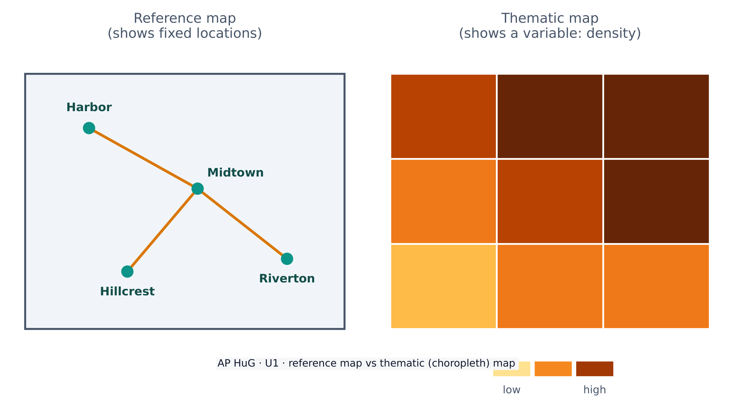
Maps come in two big families. A reference map 参考地图 shows fixed locations — coastlines, borders, roads, cities (a road atlas or Google Maps). A thematic map 专题地图 shows how one variable changes across space — rainfall, income, or population density. AP Human Geography uses thematic maps constantly.

Because Earth is a sphere and a map is flat, every map uses a projection 投影 that stretches the globe onto paper. Projections always distort 扭曲 something — shape, area, distance, or direction. The famous Mercator projection keeps direction correct (useful for sailing) but makes high-latitude places like Greenland look far too large. There is no perfect projection; a cartographer chooses one that fits the map's purpose.

العربية

الجغرافيا هي دراسة أين الأشياء ولماذا هي هناك. أداة الجغرافيا الأساسية هي الخريطة — صورة مسطحة لجزء من سطح الأرض.

تأتي الخرائط في عائلتين كبيرتين. الخريطة المرجعية تظهر مواقع ثابتة — السواحل، الحدود، الطرق، المدن (كتاب أطلاس طرق أو جوجل ماب). الخريطة الموضوعية تظهر كيف يتغير متغير واحد عبر المساحة — الأمطار، الدخل، أو الكثافة السكانية. تستخدم AP الجغرافيا البشرية الخرائط الموضوعية باستمرار.

الخريطة المرجعية تظهر الموقع؛ الخريطة الموضوعية تظهر كيف يتغير متغير عبر المساحة

لأن الأرض كرة والخريطة مسطحة، فإن كل خريطة تستخدم مشروعاً خريطياً يمد الكرة الأرضية على الورق. المشاريع دائماً تشوه شيئاً ما — الشكل، المساحة، المسافة، أو الاتجاه. المشروع الشهير الميركاتور يحافظ على صحة الاتجاه (مفيد للملاحة) لكن يجعل الأماكن ذات خط العرض العالي مثل جرينلاند تبدو أكبر بكثير مما يجب. لا يوجد مشروع مثالي؛ يختار الخرائطي واحداً يناسب الغرض من الخريطة.

Vocabulary · ⁨مفردات⁩ Train · ⁨تدريب⁩
English العربية
map/mæp/ map
reference map/ˈrefrəns mæp/ خريطة مرجعية
thematic map/θiːˈmætɪk mæp/ خريطة موضوعية
projection/prəˈdʒekʃn/ الإسقاط
distort/dɪˈstɔːt/ تشويه
Geographic data/ˌdʒɪəˈɡræfɪk ˈdeɪtə/ البيانات الجغرافية
geospatial technologies/ˌdʒiːəʊˈspeɪʃl tekˈnɒlədʒiz/ تقنيات الموضع الجغرافي
1.2

Geographic Data · ⁨البيانات الجغرافية⁩

Syllabus · ⁨المنهج⁩
English

Enduring Understanding (IMP-1): Geographers use maps and data to depict relationships of time, space, and scale.

Learning Objective IMP-1.B: Identify different methods of geographic data collection.

  • IMP-1.B.1 Data may be gathered in the field by organizations or by individuals.
  • IMP-1.B.2 Geospatial technologies include geographic information systems (GIS), satellite navigation systems, remote sensing, and online mapping and visualization.
  • IMP-1.B.3 Spatial information can come from written accounts in the form of field observations, media reports, travel narratives, policy documents, personal interviews, landscape analysis, and photographic interpretation.
العربية

الفهم الدائم (IMP-1): يستخدم الجغرافيون الخرائط والبيانات لتوضيح علاقات الزمان والمكان والنطاق.

هدف التعلم IMP-1.B: تحديد طرق مختلفة لجمع البيانات الجغرافية.

  • IMP-1.B.1 يمكن جمع البيانات في الموقع الميداني من قبل المنظمات أو الأفراد.
  • IMP-1.B.2 تشمل التقنيات المكانية نظم المعلومات الجغرافية (GIS)، وأنظمة الملاحة بالأقمار الصناعية، والاستشعار عن بعد، ورسم الخرائط عبر الإنترنت والتصور.
  • IMP-1.B.3 يمكن أن تأتي المعلومات المكانية من السرد المكتوب على شكل ملاحظات ميدانية، وتقارير إعلامية، وسرد رحلات، ومستندات سياسية، ومقابلات شخصية، وتحليل المناظر الطبيعية، وتفسير الصور الفوتوغرافية.

Source: College Board AP Course and Exam Description · ⁨المصدر: وصف دورة وامتحان College Board AP⁩

English

Geographic data 地理数据 is any information tied to a location. Geographers collect it in the field (counting, surveying, interviewing) and remotely with technology.

Key geospatial technologies 地理空间技术 you must know:

  • GIS 地理信息系统 (Geographic Information System) — software that layers many kinds of spatial data so patterns can be compared.
  • GPS (satellite navigation) — pinpoints exact location on Earth.
  • Remote sensing 遥感 — gathers data from satellites or aircraft without touching the ground.

Data also comes from written sources: field observations, media reports, travel writing, policy documents, interviews, and photographs.

العربية
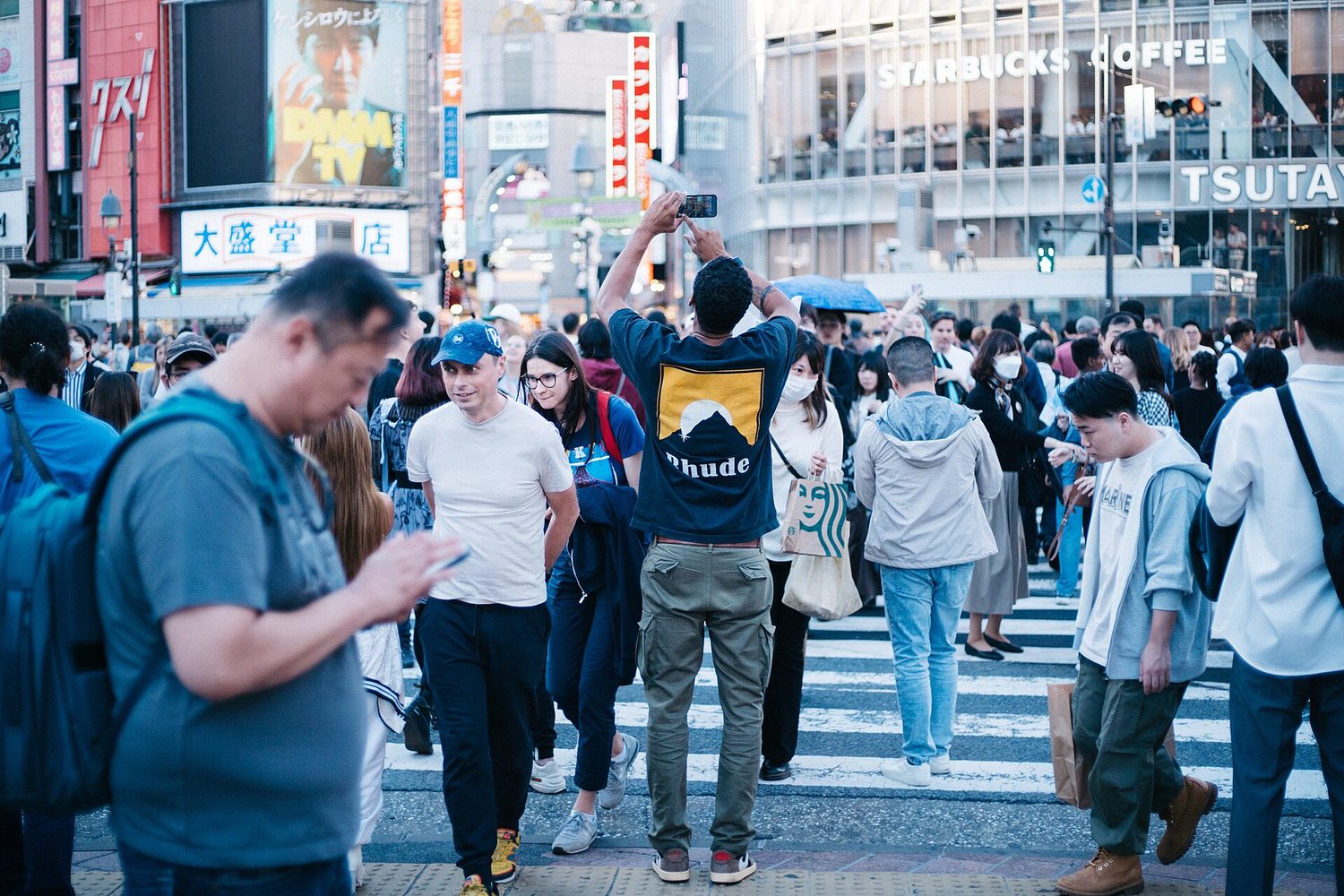
خط أفقي حضري كثيف من الأعلى: الخرائط والبيانات المكانية تظهر كيف يتوزع الناس على الأرض
صورة أفقية لمدينة كثيفة من الأعلى: الخرائط والبيانات المكانية تظهر كيفية توزيع الناس على الأرض

البيانات الجغرافية هي أي معلومات مرتبطة بموقع ما. يجمع الجغرافيون بياناتها في الميدان (العد، المسح، المقابلات) وعن بُعد باستخدام التكنولوجيا.

تقنيات مكانية جيغرافية رئيسية يجب أن تعرفها:

  • نظام المعلومات الجغرافية GIS — برنامج يدمج أنواعاً متعددة من البيانات المكانية حتى يمكن مقارنة الأنماط.
  • نظام تحديد المواقع GPS (الملاحة القمرية) — يحدد موقعاً دقيقاً على الأرض.
  • الرصد عن بُعد — يجمع البيانات من الأقمار الصناعية أو الطائرات دون لمس الأرض.

تأتي البيانات أيضاً من مصادر مكتوبة: ملاحظات ميدانية، تقارير إعلامية، كتابات السفر، وثائق السياسات، مقابلات، وصور فوتوغرافية.

Vocabulary · ⁨مفردات⁩ Train · ⁨تدريب⁩
English العربية
GIS/ˌdʒiː aɪ ˈes/ نظم المعلومات الجغرافية GIS
1.3

The Power of Geographic Data · ⁨قوة البيانات الجغرافية⁩

Syllabus · ⁨المنهج⁩
English

Enduring Understanding (IMP-1): Geographers use maps and data to depict relationships of time, space, and scale.

Learning Objective IMP-1.C: Explain the geographical effects of decisions made using geographical information.

  • IMP-1.C.1 Geospatial and geographical data, including census data and satellite imagery, are used at all scales for personal, business and organizational, and governmental decision- making purposes.
العربية

الفهم الدائم (IMP-1): يستخدم الجغرافيون الخرائط والبيانات لتوضيح علاقات الزمان والمكان والنطاق.

هدف التعلم IMP-1.C: شرح الآثار الجغرافية للقرارات المتخذة باستخدام المعلومات الجغرافية.

  • IMP-1.C.1 تُستخدم البيانات المكانية والجغرافية، بما في ذلك بيانات التعداد والصور الفضائية، على جميع النطاقات لأغراض اتخاذ القرارات الشخصية والتجارية والمنظيمية والحكومية.

Source: College Board AP Course and Exam Description · ⁨المصدر: وصف دورة وامتحان College Board AP⁩

English

Data is powerful because it drives decisions. Businesses use it to choose store locations, governments use census data to plan schools and roads, and aid agencies use it to send help after a disaster.

But data is never neutral. Who collects it, which categories they use, and how a map is drawn can all shape the message. A map can inform — or it can mislead — so a good geographer always asks where the data came from and what it leaves out.

العربية

البيانات قوية لأنها تقود القرارات. تستخدم الشركات البيانات لاختيار مواقع المتاجر، وتستخدم الحكومات بيانات التعداد التخطيطي للمدارس والطرق، وتستخدم وكالات الإغاثة البيانات لإرسال المساعدة بعد الكوارث.

لكن البيانات ليست محايدة أبداً. من يجمعها، أي فئات يستخدمها، وكيف تُرسم الخريطة يمكن أن يشكل الرسالة. الخريطة قد تُعلّم — أو قد تضلل — لذلك يسأل الجغرافي الجيد دائماً من أين جاءت البيانات وماذا تستثني.

1.4

Spatial Concepts · ⁨المفاهيم المكانية⁩

Syllabus · ⁨المنهج⁩
English

Enduring Understanding (PSO-1): Geographers analyze relationships among and between places to reveal important spatial patterns.

Learning Objective PSO-1.A: Define major geographic concepts that illustrate spatial relationships.

  • PSO-1.A.1 Spatial concepts include absolute and relative location, space, place, flows, distance decay, time-space compression, and pattern.
العربية

الفهم الدائم (PSO-1): يحلل الجغرافيون العلاقات داخل وبين الأماكن للكشف عن أنماط مكانية مهمة.

هدف التعلم PSO-1.A: تعريف المفاهيم الجغرافية الرئيسية التي توضح العلاقات المكانية.

  • PSO-1.A.1 تشمل المفاهيم المكانية الموقع المطلق والنسبي، والمكان، والتدفقات، وتناقص المسافة، وانضغاط الزمكان، والنمط.

Source: College Board AP Course and Exam Description · ⁨المصدر: وصف دورة وامتحان College Board AP⁩

English
Distance decay

Geographers describe location and pattern with a precise vocabulary.

  • Absolute location 绝对位置 is an exact address — latitude and longitude. Relative location 相对位置 describes a place by what is near it ("north of the river").
  • Absolute distance is measured in kilometres; relative distance is measured in time, cost, or effort.
  • Space–time compression 时空压缩 is the shrinking of the felt distance between places as transport and communication improve.
  • Distance decay 距离衰减 means that interaction between two places weakens as the distance between them grows.

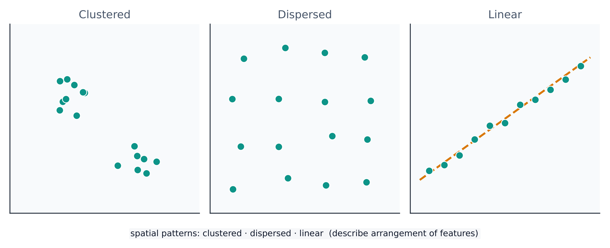
A spatial pattern 空间格局 is how things are arranged: clustered 聚集 (bunched together), dispersed 分散 (spread apart), or linear (along a line such as a road). Reading the pattern is the first step in explaining why it exists.

العربية
تآكل المسافة

يصف الجغرافيون الموقع والنمط بمفردات دقيقة.

  • الموقع المطلق هو عنوان دقيق — خط العرض وطول الخط. الموقع النسبي يصف مكاناً بما هو قريب منه ("شمال النهر").
  • المسافة المطلقة تُقاس بالكيلومترات؛ المسافة النسبية تُقاس بالوقت، التكلفة، أو الجهد.
  • ضغط الزمان-المكان Space-time compression هو انكماش المسافة المحسوسة بين الأماكن مع تحسين وسائل النقل والاتصالات.
  • تآكل المسافة Distance decay يعني أن التفاعل بين مكانين يضعف كلما زادت المسافة بينهما.
يمكن أن تتجمع النقاط على الأرض أو تتوزع أو تُرتب على خط ما
النقاط يمكن أن تتجمع، أو تتوزع، أو تُرتب على خط — والنمط المكاني بحد ذاته يُعدّ بيانات

النمط المكاني هو كيفية ترتيب الأشياء: متجمع (متكتل معاً)، متوزع (متباعد)، أو خطي (على طول خط مثل طريق). قراءة النمط هي الخطوة الأولى في شرح السبب وراء وجوده.

Vocabulary · ⁨مفردات⁩ Train · ⁨تدريب⁩
English العربية
Distance decay/ˈdɪstəns dɪˈkeɪ/ تراجع المسافة
spatial pattern/ˈspeɪʃl ˈpætn/ النمط المكاني
clustered/ˈklʌstəd/ متجمعة
dispersed/dɪˈspɜːst/ متناثرة
Environmental determinism/enˌvaɪrənˈmentl dɪˈtɜːmɪnɪzəm/ الحتمية البيئية
Possibilism/ˈpɒsɪbɪlɪzəm/ الإمكانيات
cultural landscape/ˈkʌltʃərəl ˈlændskeɪp/ المشهد الثقافي
Watch lesson · ⁨شاهد الدرس⁩
1.5

Human-Environmental Interaction · ⁨التفاعل البشري-البيئي⁩

Syllabus · ⁨المنهج⁩
English

Enduring Understanding (PSO-1): Geographers analyze relationships among and between places to reveal important spatial patterns.

Learning Objective PSO-1.B: Explain how major geographic concepts illustrate spatial relationships.

  • PSO-1.B.1 Concepts of nature and society include sustainability, natural resources, and land use.
  • PSO-1.B.2 Theories regarding the interaction of the natural environment with human societies have evolved from environmental determinism to possibilism.
العربية

الفهم الدائم (PSO-1): يحلل الجغرافيون العلاقات داخل وبين الأماكن للكشف عن أنماط مكانية مهمة.

هدف التعلم PSO-1.B: شرح كيفية توضيح المفاهيم الجغرافية الرئيسية للعلاقات المكانية.

  • PSO-1.B.1 تشمل مفاهيم الطبيعة والمجتمع الاستدامة، والموارد الطبيعية، واستخدام الأراضي.
  • PSO-1.B.2 تطورت النظريات حول تفاعل البيئة الطبيعية مع المجتمعات البشرية من الحتمية البيئية إلى الإمكانية.

Source: College Board AP Course and Exam Description · ⁨المصدر: وصف دورة وامتحان College Board AP⁩

English

People and the environment shape each other. Three older ideas describe this:

  • Environmental determinism 环境决定论 — the (now rejected) claim that the physical environment determines how a culture develops.
  • Possibilism 可能论 — the accepted view that the environment sets limits, but people choose how to respond using technology and culture.

The cultural landscape 文化景观 — farms, cities, and roads built on the land — is the visible result of this interaction. Sustainability asks how people can use natural resources without using them up.

العربية
انتشار حضري عند حافة المدينة: التفاعل بين الإنسان والبيئة يعيد تشكيل المناظر الطبيعية
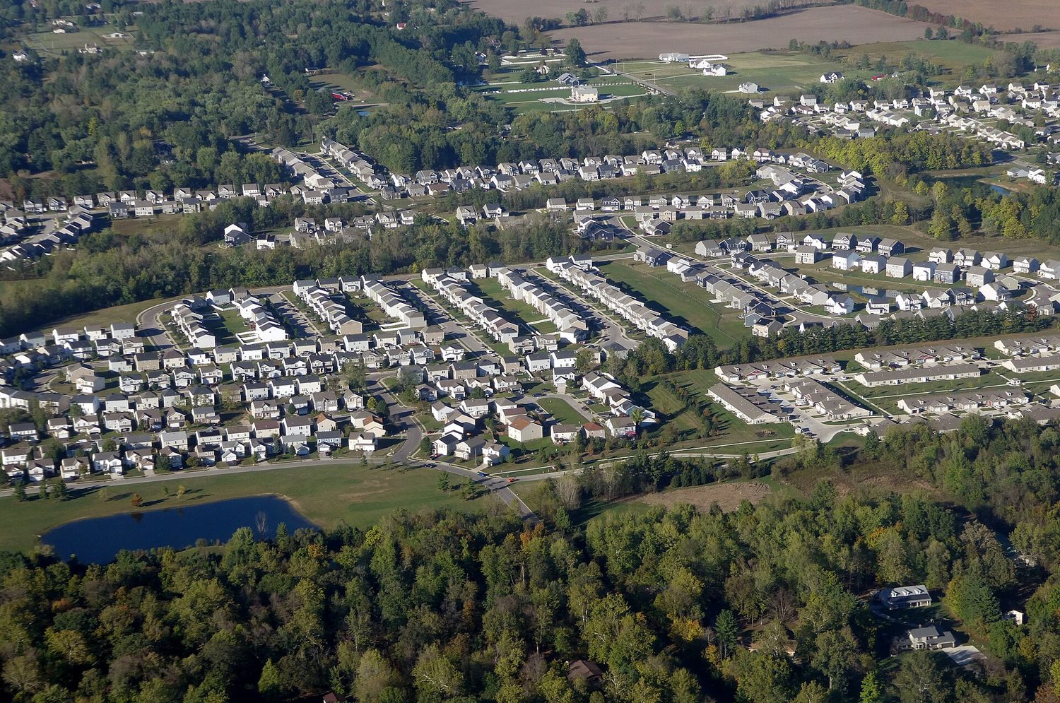
توسع حضري عند حافة المدينة: التفاعل البشري-البيئي يعيد تشكيل المناظر الطبيعية

يُشكّل البشر والبيئة بعضهم البعض. ثلاثة مفاهيم قديمة تصف ذلك:

  • الحتمية البيئية — الادعاء (المرفوض حالياً) بأن البيئة الفيزيائية تحدد كيفية تطور ثقافة ما.
  • الإمكانية — الرأي المقبول بأن البيئة تضع حدوداً، لكن البشر يختارون كيفية الاستجابة باستخدام التكنولوجيا والثقافة.

المشهد الثقافي — المزارع والمدن والطرق المبنية على الأرض — هو النتيجة المرئية لهذا التفاعل. الاستدامة تطرح كيف يمكن للبشر استخدام الموارد الطبيعية دون استنفادها.

1.6

Scales of Analysis · ⁨مقاييس التحليل⁩

Syllabus · ⁨المنهج⁩
English

Enduring Understanding (PSO-1): Geographers analyze relationships among and between places to reveal important spatial patterns.

Learning Objective PSO-1.C: Define scales of analysis used by geographers.

  • PSO-1.C.1 Scales of analysis include global, regional, national, and local.

Learning Objective PSO-1.D: Explain what scales of analysis reveal.

  • PSO-1.D.1 Patterns and processes at different scales reveal variations in, and different interpretations of, data.
العربية

الفهم الدائم (PSO-1): يحلل الجغرافيون العلاقات داخل وبين الأماكن للكشف عن أنماط مكانية مهمة.

هدف التعلم PSO-1.C: تعريف نطاقات التحليل المستخدمة من قبل الجغرافيين.

  • PSO-1.C.1 تشمل نطاقات التحليل العالمية والإقليمية والوطنية والمحلية.

هدف التعلم PSO-1.D: شرح ما تكشفه نطاقات التحليل.

  • PSO-1.D.1 تكشف الأنماط والعمليات على نطاقات مختلفة عن اختلافات وتفسيرات مختلفة للبيانات.

Source: College Board AP Course and Exam Description · ⁨المصدر: وصف دورة وامتحان College Board AP⁩

English

Scale of analysis 分析尺度 is the level at which you look at data — global, regional, national, or local. The same pattern can look completely different at different scales.

For example, a country may look wealthy at the national scale, yet contain very poor neighbourhoods at the local scale. Zooming in or out — changing the scale — reveals patterns that were hidden before. Exam questions often ask you to explain a process "at various scales."

Worked example (a real AP exam question). "The map focuses on a regional scale. Explain a possible limitation of drawing country-scale conclusions from a regional-scale map." (2025) A full-mark answer: "The map shows only one region, so its pattern may not represent the whole country — other regions could look very different, so a conclusion drawn at the regional scale would be inaccurate at the country scale." The command word Explain asks for reasoning: state the limitation and say why changing the scale changes the pattern. Just writing "the scales are different" does not earn the mark.

العربية

مقياس التحليل هو المستوى الذي تنظر من خلاله إلى البيانات — عالمي، إقليمي، وطني، أو محلي. نفس النمط قد يبدو مختلفاً تماماً عند مقاييس مختلفة.

نمط يتكامل على مختلف المستويات: عالمي، إقليمي، وطني، ومحلي
نفس المكان يندمج داخل مقاييس أكبر فأكثر — المقياس الذي تختاره يغير النمط الذي تراه

على سبيل المثال، قد تبدو دولة ثرية على مستوى وطن، بينما تحتوي أحياء فقيرة جداً على مستوى محلي. التقريب أو التباعد — أي تغيير المقياس — يكشف عن أنماط كانت مخفية سابقاً. أسئلة الامتحانات غالباً ما تطلب منك شرح عملية "على مستويات متعددة".

مثال محلول (سؤال حقيقي من امتحان AP). "تركز الخريطة على مستوى إقليمي. اشرح قيدًا محتملاً لاستخلاص استنتاجات على مستوى وطن من خريطة ذات مستوى إقليمي." (2025) إجابة كاملة الدرجة: "تُظهر الخريطة منطقة واحدة فقط، لذا فإن نمطها قد لا يمثلCountry ككل — قد تبدو مناطق أخرى مختلفة تمامًا، لذا فإن استنتاجًا مستخلصًا على المستوى الإقليمي سيكون غير دقيق على المستوى الوطني." كلمة الأمر اشرح تتطلب تقديم السبب: حدد القيد و اذكر لماذا تغيير المقياس يغير النمط. كتابة "المقاييس مختلفة" فقط لا تكسب الدرجة.

1.7

Regional Analysis · ⁨التحليل الإقليمي⁩

Syllabus · ⁨المنهج⁩
English

Enduring Understanding (SPS-1): Geographers analyze complex issues and relationships with a distinctively spatial perspective.

Learning Objective SPS-1.A: Describe different ways that geographers define regions.

  • SPS-1.A.1 Regions are defined on the basis of one or more unifying characteristics or on patterns of activity.
  • SPS-1.A.2 Types of regions include formal, functional, and perceptual/vernacular.
  • SPS-1.A.3 Regional boundaries are transitional and often contested and overlapping.
  • SPS-1.A.4 Geographers apply regional analysis at local, national, and global scales.
العربية

الفهم الدائم (SPS-1): يحلل الجغرافيون القضايا والعلاقات المعقدة بمنظور مكاني مميز.

هدف التعلم SPS-1.A: وصف الطرق المختلفة التي يُعرّف بها الجغرافيون المناطق.

  • SPS-1.A.1 تُعرف المناطق بناءً على سمة واحدة أو أكثر موحدة أو أنماط من النشاط.
  • SPS-1.A.2 تشمل أنواع المناطق الرسمية، والوظيفية، والإدراكية/العامية.
  • SPS-1.A.3 حدود المناطق انتقالية وغالبًا ما تكون محل نزاع ومتداخلة.
  • SPS-1.A.4 يطبق الجغرافيون التحليل الإقليمي على المستويات المحلية والوطنية والعالمية.

Source: College Board AP Course and Exam Description · ⁨المصدر: وصف دورة وامتحان College Board AP⁩

English

A region 区域 is an area with one or more shared features that make it different from surrounding areas. Geographers use three types:

  • Formal (uniform) region 均质区域 — everyone shares a measurable trait (a country, a wheat-growing belt, a language area).
  • Functional (nodal) region 功能区域 — organised around a central node, like a city and its commuter zone or a pizza shop's delivery area.
  • Perceptual (vernacular) region 感知区域 — defined by people's feelings and beliefs, with fuzzy borders (the "American South", the "Middle East").

Regions are made by geographers, not found in nature — so their borders can be argued about, which is exactly why they are useful for analysis.

العربية

المنطقة هي مساحة تتميز بميزة واحدة أو أكثر تجعلها مختلفة عن المناطق المحيطة. يستخدم الجغرافيون ثلاثة أنواع:

  • منطقة رسمية (متجانسة) — يشترك الجميع في سمة قابلة للقياس (دولة، حزام لزراعة القمح، منطقة لغوية).
  • منطقة وظيفية (عقدية) — منظمة حول عقدة مركزية، مثل مدينة ومنطقة التنقل إليها أو منطقة توصيل مطعم بيتزا.
  • منطقة إدراكية (عامية) — تُعرّف بناءً على مشاعر وأ beliefs الناس، حدودها ضبابية ("جنوب أمريكا"، "الشرق الأوسط").

المناطق من صنع الجغرافيين، وليست موجودة في الطبيعة — لذا يمكن النقاش حول حدودها، وهذا بالضبط ما يجعلها مفيدة للتحليل.

Explore · ⁨استكشف⁩

Sort each example into the right kind of region · ⁨صنف كل مثال في النوع الصحيح من المناطق⁩

A formal region shares one measured trait, a functional region is organised around a node, and a perceptual region is defined by people's feelings. · ⁨المناطق الرسمية تشترك في سمة واحدة قابلة للقياس، والمناطق الوظيفية منظمة حول نقطة محورية، والمناطق الإدراكية تُعرف بمشاعر الناس.⁩

1.7

Exam tips · ⁨نصائح للامتحان⁩

English
  • Always name a map projection's trade-off: what it preserves versus distorts (Mercator keeps direction but exaggerates area).
  • State whether data is quantitative or qualitative, and match a source (GIS, GPS, remote sensing, census) to its use.
  • Distinguish absolute from relative location, and use distance decay and time-space compression in any flow answer.
  • Mind the scale of analysis: a national average hides local variation — say so explicitly.
  • Classify every region as formal, functional, or perceptual, and justify it by the defining trait.
العربية
  • always اسم مشروع الخرائط وتبادله: ما يحفظه مقابل ما يشوهه (Mercer يحفظ الاتجاه لكنه يبالغ في المساحة).
  • State whether data is quantitative or qualitative, and match a source (GIS, GPS, remote sensing, census) to its use.
  • Distinguish absolute from relative location, and use distance decay and time-space compression in any flow answer.
  • Mind the scale of analysis: a national average hides local variation — say so explicitly.
  • Classify every region as formal, functional, or perceptual, and justify it by the defining trait.
Vocabulary · ⁨مفردات⁩ Train · ⁨تدريب⁩
English العربية
Remote sensing/rɪˈməʊt ˈsensɪŋ/ الاستشعار عن بعد
Absolute location/ˈæbsəluːt ləʊˈkeɪʃn/ الموقع المطلق
Relative location/ˈrelətɪv ləʊˈkeɪʃn/ الموقع النسبي
Space–time compression/speɪs taɪm kəmˈpreʃn/ ضغط الزمان والمكان
Scale of analysis/skeɪl ɒv əˈnæləsɪs/ مقياس التحليل
region/ˈriːdʒn/ منطقة
Formal (uniform) region/ˈfɔːml ˈriːdʒn/ منطقة رسمية (متجانسة)
Functional (nodal) region/ˈfʌŋkʃənl ˈriːdʒn/ منطقة وظيفية (عقدية)
Perceptual (vernacular) region/pəˈseptʃuːəl ˈriːdʒn/ منطقة إدراكية (دارجة)

Interactive lessons on this topic · ⁨دروس تفاعلية حول هذا الموضوع⁩

Work through it step by step, with instant-check exercises. · ⁨ا-working عليه خطوة بخطوة، مع تمارين تحقق فوري.⁩

Past Papers · ⁨أوراق الامتحانات السابقة⁩

More topics in AP Human Geography · ⁨الجغرافيا البشرية (AP)⁩ · ⁨المزيد من المواضيع في AP Human Geography · ⁨الجغرافيا البشرية (AP)⁩⁩

Log in or create account · ⁨تسجيل الدخول أو إنشاء حساب⁩

IGCSE, A-Level & AP