Skip to content · ⁨דלג לתוכן⁩

Cities and Urban Land-Use Patterns and Processes · ⁨דפוסי תהליכים וערים ותשתיות שטחים עירוניים⁩

AP Human Geography · ⁨גיאוגרפיה אנושית - AP⁩ · Topic 6 · ⁨נושא 6⁩

Video lesson for this topic · ⁨שיעור וידאו לנושא זה⁩ Open the video page · ⁨פתח את עמוד הוידאו⁩
8:14

דפוסי תהליכים וערים ותשתיות שטחים עירוניים

יותר מחצי מתושבי כדור הארץ חיים כיום בערים, והחלק הזה עדיין גדל. עיר יכולה למשוך כסף, תעסוקה ורעיונות מכל רחבי הכוכב. ועל…

English narration · English + 中文 subtitles burned in · ⁨קריאת קול באנגלית · תרגום אנגלי + סינית שרוף בתוך הסרטון⁩

6.1 6.2

Origin and Growth of Cities · ⁨מוצא וגודל הערים⁩

Syllabus · ⁨סיילבוס⁩
English

Enduring Understanding (PSO-6): The presence and growth of cities vary across geographical locations because of physical geography and resources.

Learning Objective PSO-6.A: Explain the processes that initiate and drive urbanization and suburbanization.

  • PSO-6.A.1 Site and situation influence the origin, function, and growth of cities.
  • PSO-6.A.2 Changes in transportation and communication, population growth, migration, economic development, and government policies influence urbanization.
עברית

הבנה מתמשכת (PSO-6): נוכחות וגודל הערים משתנים בהתאם למיקומים גיאוגרפיים בשל גיאוגרפיה פיזית ומשאבים.

מטרות למידה PSO-6.A: להסביר את התהליכים שמפעילים ודוחפים את העירוניות והעירוביות.

  • PSO-6.A.1 מיקום ומצב משפיעים על מקור, פונקציה וגודל הערים.
  • PSO-6.A.2 שינויים בתחבורה ובתקשורת, גידול אוכלוסייה, הגירה, פיתוח כלכלי ומדיניות ממשלתית משפיעים על העירוניות.
English

Enduring Understanding (PSO-6): The presence and growth of cities vary across geographical locations because of physical geography and resources.

Learning Objective PSO-6.A: Explain the processes that initiate and drive urbanization and suburbanization.

  • PSO-6.A.3 Megacities and metacities are distinct spatial outcomes of urbanization increasingly located in countries of the periphery and semiperiphery.
  • PSO-6.A.4 Processes of suburbanization, sprawl, and decentralization have created new land-use forms—including edge cities, exurbs, and boomburbs—and new challenges.
עברית

הבנה מתמשכת (PSO-6): נוכחות וגודל הערים משתנים בהתאם למיקומים גיאוגרפיים בשל גיאוגרפיה פיזית ומשאבים.

מטרות למידה PSO-6.A: להסביר את התהליכים שמפעילים ודוחפים את העירוניות והעירוביות.

  • PSO-6.A.3 megacities ומתאסיטיs הן תוצאות מרחביות נפרדות של עירוניות הממוקמות increasingly במדינות של השוליים והחצי-שוליים.
  • PSO-6.A.4 תהליכי עיבור עירוני, התפשטות ועימות (decentralization) יצרו צורות חדשות לשימוש בקרקע—כולל ערים בשוליים (edge cities), אקסטרבים ובואמבורבים—ותהליכים אתגריים חדשים.
Source: College Board AP Course and Exam Description · ⁨מקור: תיאור הקורס והמבחן של College Board AP⁩

English

Urbanization 城市化 is the growth in the share of people living in cities. It began with the agricultural surplus that freed some people from farming, and accelerated with the Industrial Revolution.

  • Urbanization rate rises fastest in developing countries today, driven by rural-to-urban migration.
  • A suburb 郊区 is a residential area on the edge of a city; suburbanization 郊区化 and sprawl 城市蔓延 spread cities outward.
  • Site 地点 (the physical features of a place) and situation 区位 (its location relative to other places) explain why a city grew where it did.
עברית

העירization היא הגידול במנת האוכלוסיה החיה בערים. הוא החל עם עודף החקלאות שחרר חלק מהאנשים מעבודת החקלאות, והוא הוקצב עם המהפכה התעשייתית.

  • קצב העירization עולה הכי מהר כיום במדינות מתפתחות, מופעל על ידי הגירה מכפרים לערים.
  • פרוור הוא אזור מגורים בקצה העיר; התעורבות עירונית והתפשטות עירונית מרחיבים את הערים החוצה.
  • אתר (התכונות הפיזיות של המקום) ומצב (מיקומו ביחס למקומות אחרים) מסבירים מדוע עיר גדלה במקום בו גדלה.
6.3

Cities and Globalization · ⁨ערים והתמודדות עם עולמיות⁩

Syllabus · ⁨סיילבוס⁩
English

Enduring Understanding (PSO-6): The presence and growth of cities vary across geographical locations because of physical geography and resources.

Learning Objective PSO-6.B: Explain how cities embody processes of globalization.

  • PSO-6.B.1 World cities function at the top of the world’s urban hierarchy and drive globalization.
  • PSO-6.B.2 Cities are connected globally by networks and linkages and mediate global processes.
עברית

הבנה מתמשכת (PSO-6): נוכחות וגודל הערים משתנים בהתאם למיקומים גיאוגרפיים בשל גיאוגרפיה פיזית ומשאבים.

מטרה לימודית PSO-6.B: להסביר כיצד ערים משקפות תהליכי גלובליזציה.

  • PSO-6.B.1 ערים עולמיות פועלות בראש ההיררכיה העולמית של הערים ומניעות את הגלובליזציה.
  • PSO-6.B.2 ערים מקושרות גלובלית באמצעות רשתות וקישורים ומשמרות כמגשר לתהליכים גלובליים.

Source: College Board AP Course and Exam Description · ⁨מקור: תיאור הקורס והמבחן של College Board AP⁩

English

Some cities have influence far beyond their own country.

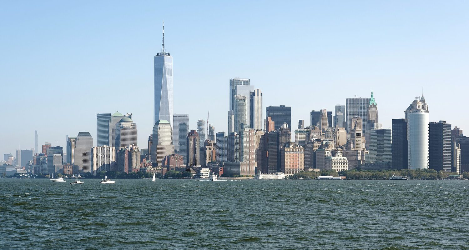
  • World cities 世界城市 (also called global cities) — such as New York, London, and Tokyo — are command centres of the global economy, finance, and culture.
  • Globalization links cities into networks; a decision in one world city can affect jobs on the other side of the planet.
עברית

חלק מערים יש השפעה רחוקה מעבר למדינה שלהן.

  • ערים עולמיות (הנקראות גם ערים עולמיות) — כמו ניו יורק, לונדון וטוקיו — הן מרכזי פיקוד לכלכלה, פיננסים ותרבות עולמית.
  • העולמית מחברת ערים לרשתות; החלטה בעיר עולמית אחת יכולה להשפיע על תעסוקה בצד השני של הכוכב.
הצטברות צפופה של גורדי שחקים במנהטן התחתונה הנראית מאשר המים, מגדל העולם החדש במרכז
קו הרקיע של מנהטן בניו יורק, עיר עולמית: בנקיה ומטה החברות שלה תומכים בתפעול הכלכלה הגלובלית
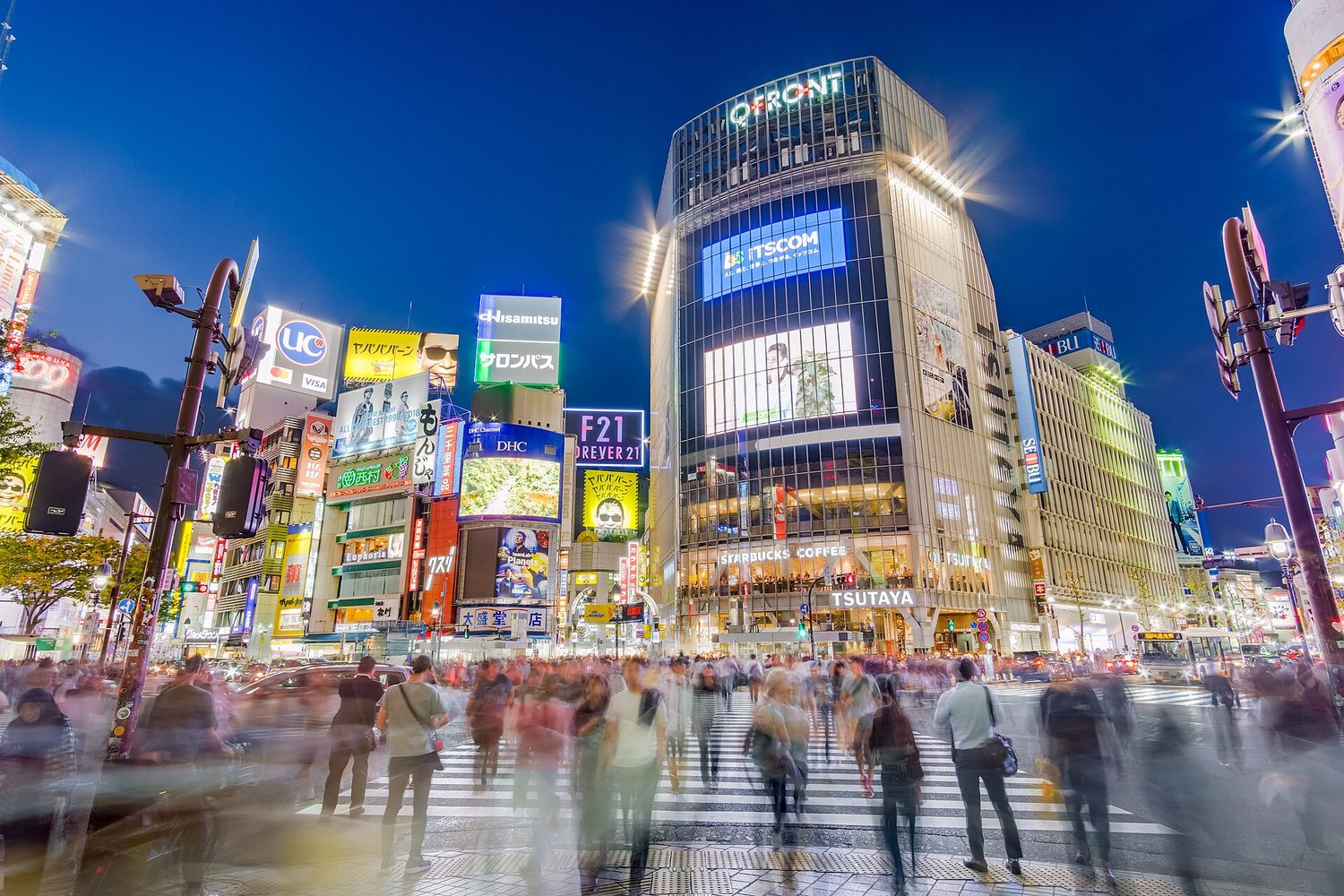
חציית שיבוקה: ערים עולמיות מצמצמות אנשים, תשתיות וקישורים גלובליים
6.4

The Distribution of Cities · ⁨חלוקת הערים⁩

Syllabus · ⁨סיילבוס⁩
English

Enduring Understanding (PSO-6): The presence and growth of cities vary across geographical locations because of physical geography and resources.

Learning Objective PSO-6.C: Identify the different urban concepts such as hierarchy, interdependence, relative size, and spacing that are useful for explaining the distribution, size, and interaction of cities.

  • PSO-6.C.1 Principles that are useful for explaining the distribution and size of cities include rank-size rule, the primate city, gravity, and Christaller’s central place theory.
עברית

הבנה מתמשכת (PSO-6): נוכחות וגודל הערים משתנים בהתאם למיקומים גיאוגרפיים בשל גיאוגרפיה פיזית ומשאבים.

מטרה לימודית PSO-6.C: לזהות מושגים עירוניים שונים כגון היררכיה, תלות הדדית, גודל יחסי ומרווחים שהם שימושיים להסבר ההתפלגות, הגודל והאינטראקציה של ערים.

  • PSO-6.C.1 עקרונות שימושיים להסבר ההתפלגות וגודל הערים כוללים חוק דרגה-גודל, העיר הראשית, כבידה (gravity) ותורת המקום המרכזי של כריסטאלר.

Source: College Board AP Course and Exam Description · ⁨מקור: תיאור הקורס והמבחן של College Board AP⁩

English
The rank-size rule and the primate city
Christaller's central place theory

Cities within a country follow patterns of size and spacing.

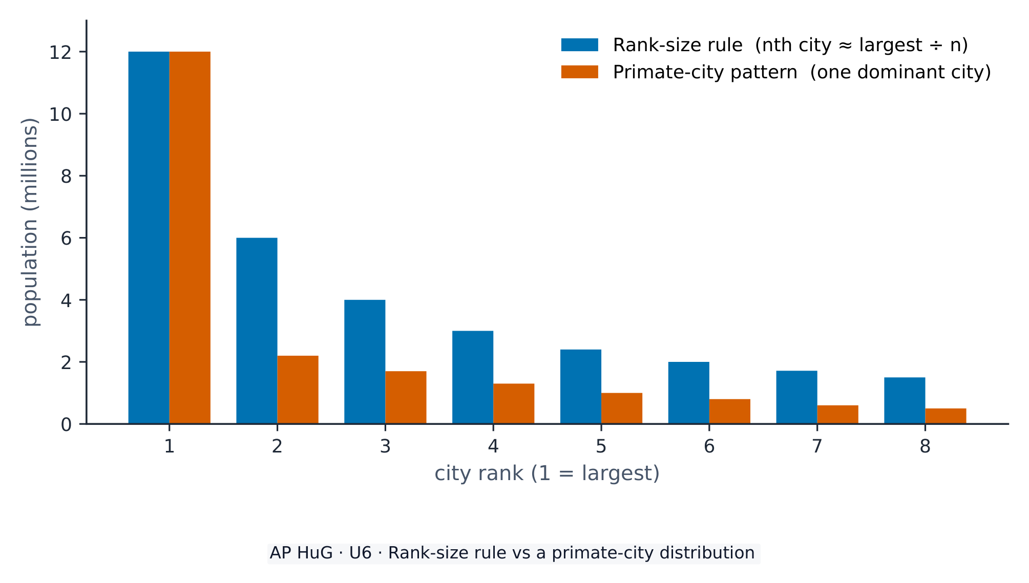
  • The rank-size rule 位序规模法则 says the nth-largest city is 1/n the size of the largest (the 2nd city is half the largest, the 3rd a third, and so on).
  • A primate city 首位城市 is far larger than all others (Paris, Bangkok), dominating its country.
  • Central place theory 中心地理论 (Christaller) explains the spacing of settlements: larger centres are fewer and farther apart and offer higher-order goods; their market area is the surrounding region they serve.

Worked example (a real AP exam question). "Compare the concept of a metacity with the concept of a world city." (2024) A full-mark answer: "A metacity is defined by size — a continuous urban area of more than 20 million people — while a world city is defined by influence, acting as a command centre for the global economy. A city such as Tokyo can be both, but a large metacity in a poorer country may not be a world city." The command word Compare needs an explicit point of difference (size versus influence), not two separate definitions sitting side by side.

עברית
חוק הדירוג-גודל ועיר הפרימה
תיאוריית המקום המרכזי של כריסטאלר

ערים בתוך מדינה פועלות לפי דפוסי גודל ומרווח.

  • חוק הגודל-דירוג קובע שהעיר ה-n בגודלה היא 1/n מגודל העיר הגדולה ביותר (העיר ה2nd היא חצי מגודל הגדולה, העיר ה3rd שליש ממנה, וכיוצא כל זה).
  • עיר פרימה היא גדולה משמעותית מכל שאר הערים (פריז, בנגקוק), ושולטת במדינתה.
  • תיאוריית המקום המרכזי (כריסטאלר) מסבירה את המרווח בין היישובים: מרכזים גדולים הם פחות נפוצים ומוקמים רחוק זה מזה יותר, ומספקים סחורות ברמת גבוהה יותר; אזור השוק שלהם הוא האזור הסובב אותם שמשרתים.
חוק גודל-דירוג לעומת חלוקת ערים ראשוניות
תחת חוק הדירוג-גודל העיר בדרגה n היא בקירוב בגודל 1/n מהגדולה ביותר; דפוס עיר הפרימה כולל עיר אחת דומיננטית הרבה גדולה יותר משאר הערים

דוגמה מפורטת (שאלה אמיתית מבחן AP). "השוו בין מושג המטרו-עיר לבין מושג העיר העולמית." (2024) תשובה מלאה לניקוד מלא: "מטרו-עיר מוגדרת על פי גודל — אזור עירוני רצוף עם יותר מ-20 מיליון תושבים — בעוד שעיר עולמית מוגדרת על פי השפעה, ומשמשת כמרכז פיקוד לכלכלה הגלובלית. עיר כמו טוקיו יכולה להיות גם כן, אך מטרו-עיר גדולה במדינה עניירה עשויה לא להיות עיר עולמית." המילה המנחה השוו דורשת נקודת הבדלה מפורשת (גודל לעומת השפעה), ולא שתי הגדרות נפרדות המונחות זו לצד זו.

6.5

The Internal Structure of Cities · ⁨המבנה הפנימי של ערים⁩

Syllabus · ⁨סיילבוס⁩
English

Enduring Understanding (PSO-6): The presence and growth of cities vary across geographical locations because of physical geography and resources.

Learning Objective PSO-6.D: Explain the internal structure of cities using various models and theories.

  • PSO-6.D.1 Models and theories that are useful for explaining internal structures of cities include the Burgess concentric-zone model, the Hoyt sector model, the Harris and Ullman multiple- nuclei model, the galactic city model, bid-rent theory, and urban models drawn from Latin America, Southeast Asia, and Africa.
עברית

הבנה מתמשכת (PSO-6): נוכחות וגודל הערים משתנים בהתאם למיקומים גיאוגרפיים בשל גיאוגרפיה פיזית ומשאבים.

מטרת למידה PSO-6.D: להסביר את המבנה הפנימי של ערים באמצעות מודלים ותאוריות שונות.

  • PSO-6.D.1 מודלים ותאוריות השימושיים להסבר מבנים פנימיים של ערים כוללים את מודל האזורים המרוכזים של ברגס, את מודל הסקטורים של הוייט, את מודל הרבה ואלמן רב-ליבות, את מודל העיר הגלקטית, תיאוריית השכירות הכפולה, ואת המודלים העירוניים הנגזרים מלטינית, דרום-מזרח אסיה ואפריקה.

Source: College Board AP Course and Exam Description · ⁨מקור: תיאור הקורס והמבחן של College Board AP⁩

English
Models of the internal city

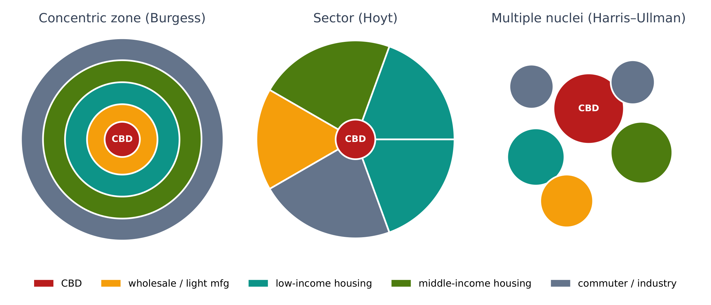
Three classic models describe how North American cities are arranged inside.

  • Concentric zone model 同心圆模型 (Burgess) — rings around the Central Business District (CBD) 中央商务区, from inner-city to commuter suburbs.
  • Sector model 扇形模型 (Hoyt) — land use grows outward in wedges along transport routes.
  • Multiple nuclei model 多核心模型 (Harris–Ullman) — the city has several centres (nodes), not just one CBD, as it grows and specialises.

Developing-world cities have their own models (e.g. the Latin American, or Griffin–Ford, model with a spine of wealth from the centre).

עברית
מודלים למבנה הפנימי של עיר

שלושה מודלים קלאסיים מתארים כיצד ערים בצפון אמריקה מסודרות בפנים.

שלושה מודלים עירוניים: אזור ריכוזי, מסלול ורבים-ליבה
המודלים האזור הריכוזי, המסלול והרבים-ליבה מסבירים כל אחד בנפרד את שימוש בקרקע בעיר
  • מודל האזור הריכוזי (ברג'ס) — טבעות סביב מרכז העסקים המרכזי (CBD), מהעיר הפנימית ועד לפרווריות נסיעת יום.
  • מודל המסלול (הואיט) — שימוש בקרקע מתרחב החוצה במחרשות לאורך דרכי תחבורה.
  • מודל הרבים-ליבה (האריס–אולמן) — לעיר ישנם מרכזים רבים (צמתים), ולא רק CBD אחד, ככל שהיא מתרחבת ומתמחה.

ערים בעולם המתפתח יש להן את המודלים הייחודיים שלהן (למשל, המודל של אמריקה הלטינית, או מודל גריפין–פורד עם עמוד שדרות עושר מהמרכז).

Explore · ⁨חקור⁩

Which urban model is it? · ⁨אילו מודל עירוני זה?⁩

The concentric zone model uses rings around the CBD; the sector model uses wedges along transport routes; the multiple nuclei model has several centres. · ⁨המודל האזורים המרכזיים משתמש בטבעות סביב המרכז העסקי המרכזי; המודל הסেকטורי משתמש במרוחות לאורך מסלולי תחבורה; המודל רב-ליבות כולל מספר מרכזים.⁩

6.6 6.7

Density, Land Use, and Infrastructure · ⁨צפיפות, שימוש בקרקע ותשתית⁩

Syllabus · ⁨סיילבוס⁩
English

Enduring Understanding (IMP-6): The attitudes and values of a population, as well as the balance of power within that population, are reflected in the built landscape.

Learning Objective IMP-6.A: Explain how low-, medium-, and high-density housing characteristics represent different patterns of residential land use.

  • IMP-6.A.1 Residential buildings and patterns of land use reflect and shape the city’s culture, technological capabilities, cycles of development, and infilling.
עברית

הבנה מתמשכת (IMP-6): יחסים וערכי האוכלוסייה, כמו גם איזון הכוחות בתוכה, משתקפים בנוף הבנוי.

מטרת למידה IMP-6.A: להסביר כיצד מאפייני דיור בצפיפות נמוכה, בינונית וגבוהה מייצגים דפוסים שונים של שימוש בקרקע מגורים.

  • IMP-6.A.1 בנייני מגורים ודפוסי שימוש בקרקע משקפים ומעצבים את התרבות של העיר, יכולות טכנולוגיות, מחזורי פיתוח והשקעה חוזרת בקרקע.
English

Enduring Understanding (IMP-6): The attitudes and values of a population, as well as the balance of power within that population, are reflected in the built landscape.

Learning Objective IMP-6.B: Explain how a city’s infrastructure relates to local politics, society, and the environment.

  • IMP-6.B.1 The location and quality of a city’s infrastructure directly affects its spatial patterns of economic and social development.
עברית

הבנה מתמשכת (IMP-6): יחסים וערכי האוכלוסייה, כמו גם איזון הכוחות בתוכה, משתקפים בנוף הבנוי.

מטרת למידה IMP-6.B: להסביר כיצד תשתיות העיר קשורות לפוליטיקה מקומית, לחברה ולסביבה.

  • IMP-6.B.1 מיקום ואיכות התשתיות של העיר משפיעים ישירות על הדפוסים המרחביים של הפיתוח הכלכלי והחברתי שלה.

Source: College Board AP Course and Exam Description · ⁨מקור: תיאור הקורס והמבחן של College Board AP⁩

English
Bid-rent theory

Inside the city, land use and density change from centre to edge.

  • Density is highest near the CBD (tall buildings, high land prices) and falls outward — the bid-rent curve again.
  • Zoning 分区规划 laws separate land uses (residential, commercial, industrial).
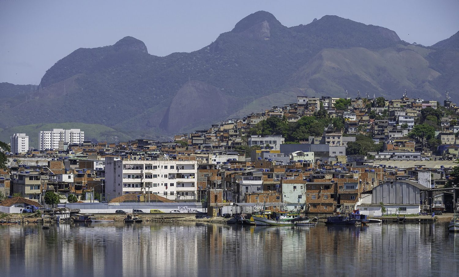
  • Infrastructure 基础设施 — roads, water, power, transit — must grow with the city; where it lags, informal settlements 非正规住区 (slums) may form.
עברית
תורת מחיר השכירות

בתוך העיר, שימוש בקרקע וצפיפות משתנים ממרכז לקצה.

  • צפיפות היא הגבוהה ביותר ליד ה-CBD (מבנים גבוהים, מחירי קרקע גבוהים) ויורדת החוצה — שוב לפי עקומת מחיר השכירות.
  • חוקי חלוקת אדמות (Zoning) מפרדים שימושי קרקע (מגורים, מסחר, תעשייה).
  • תשתית — כבישים, מים, חשמל, תחבורה — צריכה לצמוח יחד עם העיר; כאשר היא נשארת מאחור, עלולים להיווצר התיישבויות לא רשמיות (שכונות עוני).
בתים מובנים על ידי עצמם בצפיפות מכסים צלע גובה תלול מעל המים בריו דה ז'ניירו
התיישבות לא רשמית (פבלה) בצוק בריו דה ז'ניירו, שנבנתה במקום שבו דיור ושירותים לא הצליחו להספיק לגודל העירוני המהיר
Vocabulary · ⁨מילון מונחים⁩ Train · ⁨אימון⁩
English עברית
Urbanization/ˌɜːbənaɪˈzeɪʃn/ אורבניזציה
suburb/ˈsʌbɜːb/ פרוור
suburbanization/səˌbɜːbənaɪˈzeɪʃn/ עירוניות
sprawl/sprɔːl/ התפשטות עירונית
Site/saɪt/ אתר
situation/ˌsɪtʃuːˈeɪʃn/ מצב
World cities/wɜːld ˈsɪtiz/ ערים עולמיות
rank-size rule/ræŋk saɪz ruːl/ חוק הגודל והדירוג
primate city/ˈpraɪmeɪt ˈsɪti/ עיר ראשונית
Central place theory/ˈsentrəl pleɪs ˈθɪəri/ תיאוריית המקום המרכזי
Concentric zone model/kənˈsentrɪk zəʊn ˈmɒdl/ מודל האזור המרוכז
Central Business District (CBD)/ˈsentrəl ˈbɪznəs ˈdɪstrɪkt/ מרכז העסקים המרכזי (CBD)
Sector model/ˈsektə ˈmɒdl/ מודל הקוטר
Multiple nuclei model/ˈmʌltɪpl ˈnjuːklɪi ˈmɒdl/ מודל הגרעינים הרבים
Zoning/ˈzəʊnɪŋ/ חלוקה לשימושים
Infrastructure/ˈɪnfrəstrʌktʃə/ תשתיות
informal settlements/ɪnˈfɔːml ˈsetəlmənts/ יישובים לא פורמליים
Smart-growth/smɑːt ɡrəʊθ/ צמיחה חכמה
Greenbelts/ˈɡriːnbelts/ אזורי ירוק
urban renewal/ˈɜːbən rɪˈnjuːəl/ חידוש עירוני
gentrification/ˌdʒentrɪfɪˈkeɪʃn/ ג'נטריפיקציה
urban heat island/ˈɜːbən hiːt ˈaɪlənd/ אי חום עירוני
6.8 6.9

Urban Sustainability and Data · ⁨קיימות עירונית ומידע⁩

Syllabus · ⁨סיילבוס⁩
English

Enduring Understanding (IMP-6): The attitudes and values of a population, as well as the balance of power within that population, are reflected in the built landscape.

Learning Objective IMP-6.C: Identify the different urban design initiatives and practices.

  • IMP-6.C.1 Sustainable design initiatives and zoning practices include mixed land use, walkability, transportation-oriented development, and smart-growth policies, including New Urbanism, greenbelts, and slow-growth cities.

Learning Objective IMP-6.D: Explain the effects of different urban design initiatives and practices.

  • IMP-6.D.1  Praise for urban design initiatives includes the reduction of sprawl, improved walkability and transportation, improved and diverse housing options, improved livability and promotion of sustainable options. Criticisms include increased housing costs, possible de facto segregation, and the potential loss of historical or place character.
עברית

הבנה מתמשכת (IMP-6): יחסים וערכי האוכלוסייה, כמו גם איזון הכוחות בתוכה, משתקפים בנוף הבנוי.

מטרת למידה IMP-6.C: לזהות את יוזמות העיצוב העירוניות והמעשיים השונים.

  • IMP-6.C.1 יוזמות עיצוב ברקתיים ומעשיי חלוקה כוללים שימוש מעורב בקרקע, הליכה, פיתוח הממוקד בתחבורה ומדיניות גידול חכם, כולל אורבניזם חדש, אזורים ירוקים וערים בעלות גידול איטי.

מטרת למידה IMP-6.D: להסביר את ההשפעות של יוזמות עיצוב עירוניות ומעשיים שונים.

  • IMP-6.D.1 שבחים ליזמות עיצוב עירוניות כוללים הצטמצמות התפשטות עירונית, שיפור בהליכה ובתחבורה, אפשרויות דיור משופרות ומגוונות, שיפור באיכות החיים וקידום אפשרויות ברקתיות. ביקורות כוללות עליית מחירי דיור, הפרדה בפועל אפשרית, ואובדן פוטנציאלי של אופי היסטורי או מקומי.
English

Enduring Understanding (IMP-6): The attitudes and values of a population, as well as the balance of power within that population, are reflected in the built landscape.

Learning Objective IMP-6.E: Explain how qualitative and quantitative data are used to show the causes and effects of geographic change within urban areas.

  • IMP-6.E.1 Quantitative data from census and survey data provide information about changes in population composition and size in urban areas.
  • IMP-6.E.2 Qualitative data from field studies and narratives provide information about individual attitudes toward urban change.
עברית

הבנה מתמשכת (IMP-6): יחסים וערכי האוכלוסייה, כמו גם איזון הכוחות בתוכה, משתקפים בנוף הבנוי.

מטרת למידה IMP-6.E: להסביר כיצד נתונים איכותיים וכמותיים משמשים להראות את הסיבות וההשלכות של שינוי גיאוגרפי בתוך אזורות עירוניים.

  • IMP-6.E.1 נתונים כמותיים ממפקדות ונתוני סקרים מספקים מידע על שינויים בהרכב ובגודל האוכלוסייה באזורות עירוניים.
  • IMP-6.E.2 נתונים איכותיים ממחקרים בשטח וסיפורים מספקים מידע על יחסים אישיים לשינוי עירוני.

Source: College Board AP Course and Exam Description · ⁨מקור: תיאור הקורס והמבחן של College Board AP⁩

English

Planners use data and design to make cities work better.

  • Smart-growth 精明增长, mixed-use development, and transit-oriented design fight sprawl and car dependence.
  • Greenbelts 绿带 limit outward growth; urban renewal 城市更新 rebuilds decayed areas, but can cause gentrification 中产阶级化 that displaces poorer residents.
  • Census and geospatial data guide where to put schools, transit, and services.
עברית

מתכננים משתמשים ב-מידע ובעיצוב כדי לשפר את פעילות הערים.

  • פיתוח צמיחה חכמה, שימוש מעורב ועיצוב ממוקד תחבורה נלחמים בפריחה ותלות ברכב.
  • אזורים ירוקים מגבילים התרחבות החוצה; חידוש עירוני שופך אזורים מדלדלים, אך יכול לגרום לג'נטריפיקציה שמפילה תושבים עניים יותר.
  • מידע מאוכלוסין ומרחבי מידע מנחה איפה למקם בתי ספר, תחבורה ושירותים.
6.10 6.11

Challenges of Urban Changes and Sustainability · ⁨אתגרים של שינויים עירוניים וקיימות⁩

Syllabus · ⁨סיילבוס⁩
English

Enduring Understanding (SPS-6): Urban areas face unique economic, political, cultural, and environmental challenges.

Learning Objective SPS-6.A: Explain causes and effects of geographic change within urban areas.

  • SPS-6.A.1 As urban populations move within a city, economic and social challenges result, including: issues related to housing and housing discrimination such as redlining, blockbusting, and affordability; access to services; rising crime; environmental injustice; and the growth of disamenity zones or zones of abandonment.
  • SPS-6.A.2 Squatter settlements and conflicts over land tenure within large cities have increased.
  • SPS-6.A.3 Responses to economic and social challenges in urban areas can include inclusionary zoning and local food movements.
  • SPS-6.A.4 Urban renewal and gentrification have both positive and negative consequences.
  • SPS-6.A.5 Functional and geographic fragmentation of governments—the way government agencies and institutions are dispersed between state, county, city, and neighborhood levels—presents challenges in addressing urban issues.
עברית

הבנה מתמשכת (SPS-6): אזורים עירוניים מתמודדים עם אתגרים כלכליים, פוליטיים, תרבותיים וסביבתיים ייחודיים.

מטרות למידה SPS-6.A: להסביר את הסיבות וההשלכות של שינוי גיאוגרפי בתוך אזורים עירוניים.

  • SPS-6.A.1 כאשר אוכלוסיות עירוניות מתנועות בתוך עיר, נובעים מכך אתגרים כלכליים וחברתיים, הכוללים: בעיות הקשורות למגורים ולבחינת דיור כמו סיווג אדמות (redlining), תזמרת שכונות (blockbusting) והיכולת לשאת עלויות; גישה לשירותים; עלייה בשיעורי פשיעה; אי-צדק סביבתי; וגידול באזורי חסר שירותים או אזורים מוזנחים.
  • SPS-6.A.2 התגלגלויות וסכסוכים על זכויות קרקע בתוך ערים גדולות ירבו.
  • SPS-6.A.3 תגובות לאתגרים כלכליים וחברתיים באזורים עירוניים יכולות להכליל תכנון כלכלי-חברתי (inclusionary zoning) ותנועות מזון מקומי.
  • SPS-6.A.4 חידוש עירוני וג'נטריפיקציה כרוכים במ consequences חיוביות ושליליות.
  • SPS-6.A.5 הפיצול הפונקציונלי והגיאוגרפי של הממשלות—האופן שבו סוכנים ומוסדות ממשלתיים מפוזרים בין רמות מדינה, מחוז, עיר ושכונה—מייצר אתגרים בהתמודדות עם נושאים עירוניים.
English

Enduring Understanding (SPS-6): Urban areas face unique economic, political, cultural, and environmental challenges.

Learning Objective SPS-6.B: Describe the effectiveness of different attempts to address urban sustainability challenges.

  • SPS-6.B.1 Challenges to urban sustainability include suburban sprawl, sanitation, climate change, air and water quality, the large ecological footprint of cities, and energy use.
  • SPS-6.B.2 Responses to urban sustainability challenges can include regional planning efforts, remediation and redevelopment of brownfields, establishment of urban growth boundaries, and farmland protection policies.
עברית

הבנה מתמשכת (SPS-6): אזורים עירוניים מתמודדים עם אתגרים כלכליים, פוליטיים, תרבותיים וסביבתיים ייחודיים.

מטרה לימודית SPS-6.B: לתאר את יעילותם של ניסיונות שונים להתמודדות עם אתגרי שימור עירוני.

  • SPS-6.B.1 האתגרים לשימור עירוני כוללים התפשטות עירונית, היגיינה, שינויי אקלים, איכות האוויר והמים, הטביעת האקולוגית הגדולה של ערים וצריכת אנרגיה.
  • SPS-6.B.2 תגובות לאתגרי שימור עירוני יכולות להכליל מאמצי תכנון אזורי, שיקום ופיתוח מחדש של אתרים מזהמים (brownfields), הקמת גבולות צמיחה עירוניים ומדיניות הגנה על אדמות חקלאיות.

Source: College Board AP Course and Exam Description · ⁨מקור: תיאור הקורס והמבחן של College Board AP⁩

English

Rapid urban growth brings problems:

  • Social: housing shortages, segregation, and the displacement caused by gentrification.
  • Environmental: air and water pollution, the urban heat island 城市热岛 effect, waste, and heavy resource use.
  • Economic: strained budgets, congestion, and the cost of extending infrastructure to sprawling edges.

Sustainable cities try to grow up rather than out, invest in public transit, and mix homes with jobs and services.

עברית

צמיחה עירונית מהירה מביאה בעיות:

  • חברתית: מחסור בדיורים, פיצול חברתי והזזה הנגרמת מג'נטרופיקציה.
  • סביבתית: זיהום אוויר ומים, אפקט האי החם העירוני, אשפה ושימוש מוגבר במשאבים.
  • כלכלית: תקציבים מותחים, עומסי תנועה ועלויות ההרחבה של תשתיות לגבולות עירוניים מתפשטים.

ערים בר-קיימא שואפות לצמוח למעלה ולא לרוחב, להשקיע בתחבורה ציבורית ולערבב דיור עם מקומות עבודה ושירותים.

6.10 6.11

Exam tips · ⁨טיפים לבחינות⁩

English
  • Separate a city's site (physical setting) from its situation (position relative to others).
  • Apply the rank-size rule (the nth city is about 1/n of the largest) and spot a primate city.
  • Match a city description to the right model: concentric zone, sector, or multiple nuclei.
  • Link land value to density — costly central land is used by building upward.
  • Discuss change with suburbanization, sprawl, and gentrification, and smart-growth responses.
עברית
  • להפריד בין אתר העיר (ההקשר הפיזי שלה) לבין מצבה (המיקום היחסי ביחס לערים אחרות).
  • ליישם את חוק גודל-דרגה (העיר ה-n היא כ-1/n מגודל העיר הגדולה ביותר) ולזהות עיר פריוט.
  • להתאים תיאור עיר לדגם המתאים: אזור מעגלי, מסלול או ריכוזי ליבה מרובים.
  • לקשר ערך קרקע לצפיפות – קרקע יקרה במרכז נמצאת בשימוש על ידי בנייה לאורך הגובה.
  • לדון בשינויים הקשורים לעירובייה, התפשטות עירונית וג'נטרופיקציה, ובתגובות צמיחה חכמה.

Interactive lessons on this topic · ⁨שיעורים אינטראקטיביים בנושא זה⁩

Work through it step by step, with instant-check exercises. · ⁨לעבור על הדברים צעד אחר צעד, עם תרגילים לבדיקה מיידית.⁩

Past Papers · ⁨מבחני עבר⁩

More topics in AP Human Geography · ⁨גיאוגרפיה אנושית - AP⁩ · ⁨נושאים נוספים בAP Human Geography · ⁨גיאוגרפיה אנושית - AP⁩⁩

Log in or create account · ⁨היכנס או צור חשבון⁩

IGCSE, A-Level & AP