English
| Enduring Understanding | Learning Objective | Essential Knowledge |
|---|---|---|
IMP-1 | IMP-1.A |
|
한국어
| Enduring Understanding | Learning Objective | Essential Knowledge |
|---|---|---|
IMP-1 | IMP-1.A |
|
AP Human Geography · AP 인간지리학 · Topic 1 · 주제 1
 8:14
8:14
지리적 사고하기
교실의 세계 지도에서 그린란드를 보라. 아프리카 크기와 비슷해 보인다. 하지만 그렇지 않다. 아프리카는 14배 더 크다. <slow>지도가 당신을 속하지 않는 이유는 …
English narration · English + 中文 subtitles burned in · 영어 내레이션 · 영어 + 중국어 자막 burned-in
| Enduring Understanding | Learning Objective | Essential Knowledge |
|---|---|---|
IMP-1 | IMP-1.A |
|
| Enduring Understanding | Learning Objective | Essential Knowledge |
|---|---|---|
IMP-1 | IMP-1.A |
|
Source: College Board AP Course and Exam Description · 출처: College Board AP Course and Exam Description
Geography is the study of where things are and why they are there. Its most basic tool is the map 地图 — a flattened picture of some part of Earth's surface.
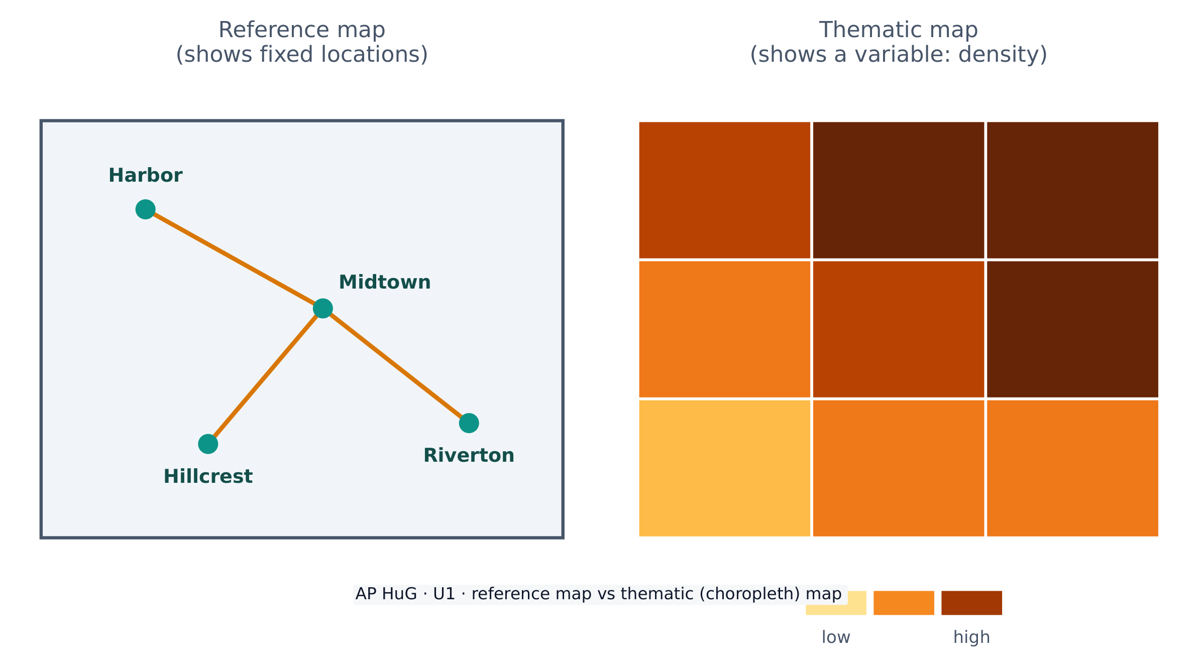
Maps come in two big families. A reference map 参考地图 shows fixed locations — coastlines, borders, roads, cities (a road atlas or Google Maps). A thematic map 专题地图 shows how one variable changes across space — rainfall, income, or population density. AP Human Geography uses thematic maps constantly.
Because Earth is a sphere and a map is flat, every map uses a projection 投影 that stretches the globe onto paper. Projections always distort 扭曲 something — shape, area, distance, or direction. The famous Mercator projection keeps direction correct (useful for sailing) but makes high-latitude places like Greenland look far too large. There is no perfect projection; a cartographer chooses one that fits the map's purpose.
지리학은 사물이 어디에 있는지와 왜 그곳에 있는지를 연구하는 학문입니다. 가장 기초적인 도구인 지도는 지구의 특정 부분을 평면화한 그림입니다.
지도는 크게 두 가지 계열로 나뉩니다. 참조 지도는 고정된 위치(해안선, 국경, 도로, 도시 등)를 보여줍니다(도로 지도나 구글 맵스). 주제 지도는 한 변수가 공간에 걸쳐 어떻게 변하는지를 보여줍니다(강수량, 소득, 인구 밀도 등). AP 인문 지리학에서는 주제 지도를 빈번하게 사용합니다.
지구란 구形体이고 지도는 평면이기 때문에, 모든 지도는 globe를 종이에 펼쳐놓는 투영법을 사용합니다. 투영법은 항상 왜곡을 수반합니다- 모양, 면적, 거리, 또는 방향 중 어느 것이든요. 유명한 メル카토르 투영법은 방향을 정확히 유지(항해용)하지만, 그린란드 같은 고위도 지역이 실제보다 훨씬 크게 보이게 만듭니다. 완벽한 투영법은 없으므로, 도화가는 지도의 목적에 맞는 것을 선택합니다.
| English | 한국어 |
|---|---|
| map/mæp/ | map |
| reference map/ˈrefrəns mæp/ | 참조 지도 |
| thematic map/θiːˈmætɪk mæp/ | 주제도 |
| projection/prəˈdʒekʃn/ | 투영 |
| distort/dɪˈstɔːt/ | 왜곡하다 |
| Geographic data/ˌdʒɪəˈɡræfɪk ˈdeɪtə/ | 지리 데이터 |
| geospatial technologies/ˌdʒiːəʊˈspeɪʃl tekˈnɒlədʒiz/ | 위성 공간 정보 기술 |

| Enduring Understanding | Learning Objective | Essential Knowledge |
|---|---|---|
IMP-1 | IMP-1.B |
|
| Enduring Understanding | Learning Objective | Essential Knowledge |
|---|---|---|
IMP-1 | IMP-1.B |
|
Source: College Board AP Course and Exam Description · 출처: College Board AP Course and Exam Description
Geographic data 地理数据 is any information tied to a location. Geographers collect it in the field (counting, surveying, interviewing) and remotely with technology.
Key geospatial technologies 地理空间技术 you must know:
Data also comes from written sources: field observations, media reports, travel writing, policy documents, interviews, and photographs.
지리 데이터는 위치와 연결된 모든 정보를 말한다. 지리학자들은 현장(계산, 측량, 인터뷰)과 기술을 이용한 원거리 수송两种方式收集它。
알아야 할 주요 공간 정보 기술(spatial technologies):
데이터는 또한 문서 자료에서도 나온다: 현장 관찰, 미디어 보도, 여행 글, 정책 문서, 인터뷰, 사진 등.
| English | 한국어 |
|---|---|
| GIS/ˌdʒiː aɪ ˈes/ | GIS |
| Remote sensing/rɪˈməʊt ˈsensɪŋ/ | 원격 감수 |
| Absolute location/ˈæbsəluːt ləʊˈkeɪʃn/ | 절대적 위치 |
| Enduring Understanding | Learning Objective | Essential Knowledge |
|---|---|---|
IMP-1 | IMP-1.C |
|
| Enduring Understanding | Learning Objective | Essential Knowledge |
|---|---|---|
IMP-1 | IMP-1.C |
|
Source: College Board AP Course and Exam Description · 출처: College Board AP Course and Exam Description
Data is powerful because it drives decisions. Businesses use it to choose store locations, governments use census data to plan schools and roads, and aid agencies use it to send help after a disaster.
But data is never neutral. Who collects it, which categories they use, and how a map is drawn can all shape the message. A map can inform — or it can mislead — so a good geographer always asks where the data came from and what it leaves out.
데이터는 결정을 주도하기 때문에 강력한 힘을 가집니다. 기업은 매장을 위한 입지를 선정할 때, 정부는 학교와 도로 계획을 세울 때, 구호 기관은 재해 후 지원 물자를 보내기 위해 데이터를 활용합니다.
하지만 데이터는 절대 중립적이지 않습니다. 누가 수집하느냐, 어떤 범위를 사용하느냐,以及如何 그리는지에 따라 모두 메시지를 형성할 수 있습니다. 지도는 정보를 전달하기도 하지만 오해를 불러일으키기도 하므로, 훌륭한 지리학자는 항상 데이터가 어디서 왔는지, 그리고 무엇을 빠뜨렸는지 묻습니다.
| Enduring Understanding | Learning Objective | Essential Knowledge |
|---|---|---|
PSO-1 | PSO-1.A |
|
| Enduring Understanding | Learning Objective | Essential Knowledge |
|---|---|---|
PSO-1 | PSO-1.A |
|
Source: College Board AP Course and Exam Description · 출처: College Board AP Course and Exam Description
Geographers describe location and pattern with a precise vocabulary.
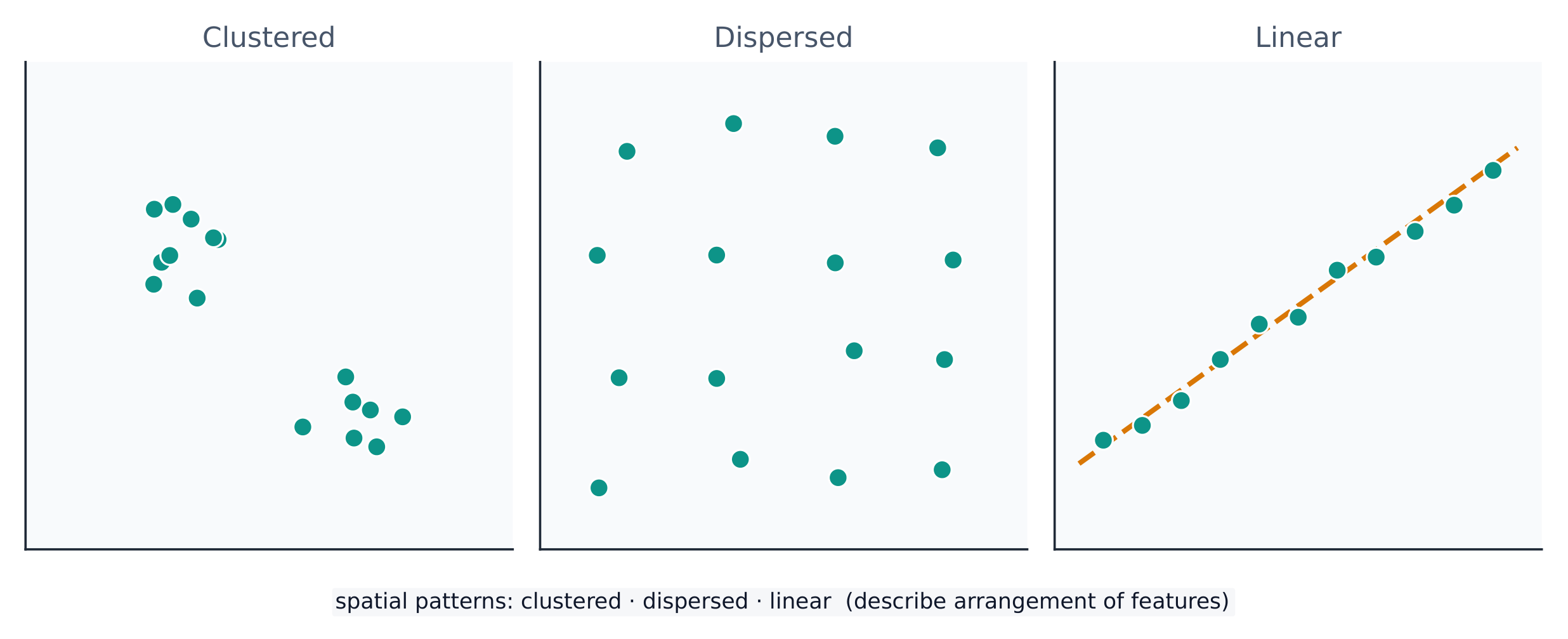
A spatial pattern 空间格局 is how things are arranged: clustered 聚集 (bunched together), dispersed 分散 (spread apart), or linear (along a line such as a road). Reading the pattern is the first step in explaining why it exists.
지리학자들은 위치와 패턴을 정밀한 어휘로 서술합니다.
공간적 패턴은 사물들이 어떻게 배치되어 있는지를 의미하며, 집중(뭉쳐 있음), 분산(퍼져 있음) 또는 선형(도로와 같은 선을 따라)으로 구분된다. 패턴을 읽는 것은 그 패턴이 존재하는 원인을 설명하기 위한 첫 단계이다.
| English | 한국어 |
|---|---|
| Relative location/ˈrelətɪv ləʊˈkeɪʃn/ | 상대 위치 |
| Space–time compression/speɪs taɪm kəmˈpreʃn/ | 공간-시간 압축 |
| Distance decay/ˈdɪstəns dɪˈkeɪ/ | 거리 감쇠 |
| spatial pattern/ˈspeɪʃl ˈpætn/ | 공간 패턴 |
| clustered/ˈklʌstəd/ | 뭉쳐 있음 |
| dispersed/dɪˈspɜːst/ | 분산된 |
| Environmental determinism/enˌvaɪrənˈmentl dɪˈtɜːmɪnɪzəm/ | 환경 결정론 |
| Possibilism/ˈpɒsɪbɪlɪzəm/ | 가능성론 |
| cultural landscape/ˈkʌltʃərəl ˈlændskeɪp/ | 문화 경관(cultural landscape) |
| Scale of analysis/skeɪl ɒv əˈnæləsɪs/ | 분석의 규모 |
| region/ˈriːdʒn/ | 지역(region) |
| Formal (uniform) region/ˈfɔːml ˈriːdʒn/ | 공식(균일) 지역 |
| Functional (nodal) region/ˈfʌŋkʃənl ˈriːdʒn/ | 기능(핵심) 지역 |
| Perceptual (vernacular) region/pəˈseptʃuːəl ˈriːdʒn/ | 인지(민속) 지역 |
| Enduring Understanding | Learning Objective | Essential Knowledge |
|---|---|---|
PSO-1 | PSO-1.B |
|
| Enduring Understanding | Learning Objective | Essential Knowledge |
|---|---|---|
PSO-1 | PSO-1.B |
|
Source: College Board AP Course and Exam Description · 출처: College Board AP Course and Exam Description
People and the environment shape each other. Three older ideas describe this:
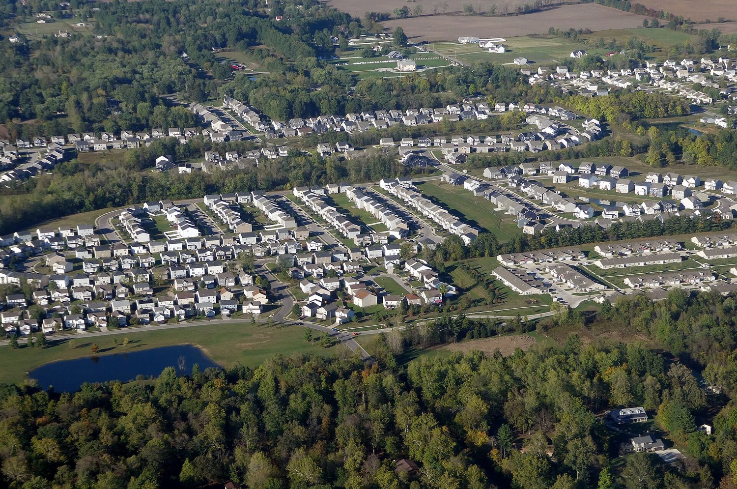
The cultural landscape 文化景观 — farms, cities, and roads built on the land — is the visible result of this interaction. Sustainability asks how people can use natural resources without using them up.
사람과 환경은 서로를 형성한다. 이를 설명하는 세 가지 전통적인 관점이 있다:
문화경관 — 농장, 도시 및 도로 등土地上에 구축된 것들은 이 상호작용의 가시적 결과물이다. 지속 가능성은 사람들이 자원을 소진하지 않으면서如何利用其自然资源询问如何在不耗尽自然资源的情况下利用它们。

| Enduring Understanding | Learning Objective | Essential Knowledge |
|---|---|---|
PSO-1 | PSO-1.C |
|
PSO-1.D |
|
| Enduring Understanding | Learning Objective | Essential Knowledge |
|---|---|---|
PSO-1 | PSO-1.C |
|
PSO-1.D |
|
Source: College Board AP Course and Exam Description · 출처: College Board AP Course and Exam Description
Scale of analysis 分析尺度 is the level at which you look at data — global, regional, national, or local. The same pattern can look completely different at different scales.
For example, a country may look wealthy at the national scale, yet contain very poor neighbourhoods at the local scale. Zooming in or out — changing the scale — reveals patterns that were hidden before. Exam questions often ask you to explain a process "at various scales."
Worked example (a real AP exam question). "The map focuses on a regional scale. Explain a possible limitation of drawing country-scale conclusions from a regional-scale map." (2025) A full-mark answer: "The map shows only one region, so its pattern may not represent the whole country — other regions could look very different, so a conclusion drawn at the regional scale would be inaccurate at the country scale." The command word Explain asks for reasoning: state the limitation and say why changing the scale changes the pattern. Just writing "the scales are different" does not earn the mark.
분석의 규모는 데이터를 바라보는 수준을 의미하며, 글로벌, 지역, 국가 또는 현지 수준이 포함된다. 동일한 패턴도 다른 규모에서는 완전히 다르게 나타날 수 있다.
예를 들어,一个国家可能在国家规模上显得富裕,但在地方规模上却包含非常贫穷的社区。放大或缩小——即改变规模——会揭示之前隐藏的pattern。考试题目常要求你在“多种尺度”下解释一个过程。
해설 예제 (실제 AP 시험 문제). "이 지도는 지역 규모에 초점을 맞추고 있습니다. 지역 규모의 지도에서 국가 단위의 결론을 도출하는 것의 가능한 한계를 설명하십시오." (2025) 만점 답안: "이 지도는 한 지역만 보여 주므로, 해당 패턴이 전국을 대표하지 않을 수 있습니다. 다른 지역은 매우 다르게 나타날 수 있으므로, 지역 규모에서 도출된 결론은 국가 규모에서는 부정확할 것입니다." 명령어 Explain(설명) 은 논리적 근거를 요구합니다. 한계를 명시하고 또한 규모가 바뀌면 패턴이 달라지는 이유를 설명해야 합니다. 단순히 "규모가 다르다"라고만 적으면 점수를 받을 수 없습니다.
| Enduring Understanding | Learning Objective | Essential Knowledge |
|---|---|---|
SPS-1 | SPS-1.A |
|
| Enduring Understanding | Learning Objective | Essential Knowledge |
|---|---|---|
SPS-1 | SPS-1.A |
|
Source: College Board AP Course and Exam Description · 출처: College Board AP Course and Exam Description
A region 区域 is an area with one or more shared features that make it different from surrounding areas. Geographers use three types:
Regions are made by geographers, not found in nature — so their borders can be argued about, which is exactly why they are useful for analysis.
지역은 주변 지역과 구별되는 하나 이상의 공통 특성을 가진 영역이다. 지리학자는 세 가지 유형을 사용한다:
지역은 지리학자가 만든 것이며 자연에 존재하지 않으므로, 그 경계는 논쟁의 여지가 있으며这正是它们用于分析的原因。
A formal region shares one measured trait, a functional region is organised around a node, and a perceptual region is defined by people's feelings. · 형식적 지역은 하나의 측정 가능한 특성을 공유하며, 기능적 지역은 노드를 중심으로 조직되고, 인지적 지역은 사람들의 느낌에 의해 정의됩니다.
Work through it step by step, with instant-check exercises. · 즉시 체크 기능 exercises를 통해 단계별로 진행하세요.
Loading subjects… · 과목 로드 중…