Skip to content · ⁨דלג לתוכן⁩

Thinking Geographically · ⁨חשיבה גיאוגרפית⁩

AP Human Geography · ⁨גיאוגרפיה אנושית - AP⁩ · Topic 1 · ⁨נושא 1⁩

Video lesson for this topic · ⁨שיעור וידאו לנושא זה⁩ Open the video page · ⁨פתח את עמוד הוידאו⁩
8:14

חשיבה גיאוגרפית

הסתכל על גרינלנד במפת עולם בכיתה. היא נראית בגודל של אפריקה. זוהי לא. אפריקה גדולה פי 14. <slow> המפה לא מושקת אותך על ידי…

English narration · English + 中文 subtitles burned in · ⁨קריאת קול באנגלית · תרגום אנגלי + סינית שרוף בתוך הסרטון⁩

1.1

Introduction to Maps · ⁨מבוא למפות⁩

Syllabus · ⁨סיילבוס⁩
English

Enduring Understanding (IMP-1): Geographers use maps and data to depict relationships of time, space, and scale.

Learning Objective IMP-1.A: Identify types of maps, the types of information presented in maps, and different kinds of spatial patterns and relationships portrayed in maps.

  • IMP-1.A.1 Types of maps include reference maps and thematic maps.
  • IMP-1.A.2 Types of spatial patterns represented on maps include absolute and relative distance and direction, clustering, dispersal, and elevation.
  • IMP-1.A.3 All maps are selective in information; map projections inevitably distort spatial relationships in shape, area, distance, and direction.
עברית

הבנה מתמשכת (IMP-1): גיאוגרפים משתמשים במפות ובנתונים כדי לתאר קשרים של זמן, מרחב ומידה.

מטרות לימוד IMP-1.A: לזהות סוגי מפות, את סוגי המידע המוצגים במפות, ואת סוגי הדפוסים והקשרים המרחביים השונים המתוארים במפות.

  • IMP-1.A.1 סוגי המפות כוללים מפות ייחוס ומפות נושאיות.
  • IMP-1.A.2 סוגי דפוסי מרחב המוצגים במפות כוללים מרחק וכיוון מוחלט ויחסי, הצטברות, פיזור וגובה.
  • IMP-1.A.3 כל המפות הן בחירה מסוימת של מידע; טכניקות ההעתקה במפות מעוותות בהכרח את הקשרים המרחביים בצורה, שטח, מרחק וכיוון.

Source: College Board AP Course and Exam Description · ⁨מקור: תיאור הקורס והמבחן של College Board AP⁩

English

Geography is the study of where things are and why they are there. Its most basic tool is the map 地图 — a flattened picture of some part of Earth's surface.

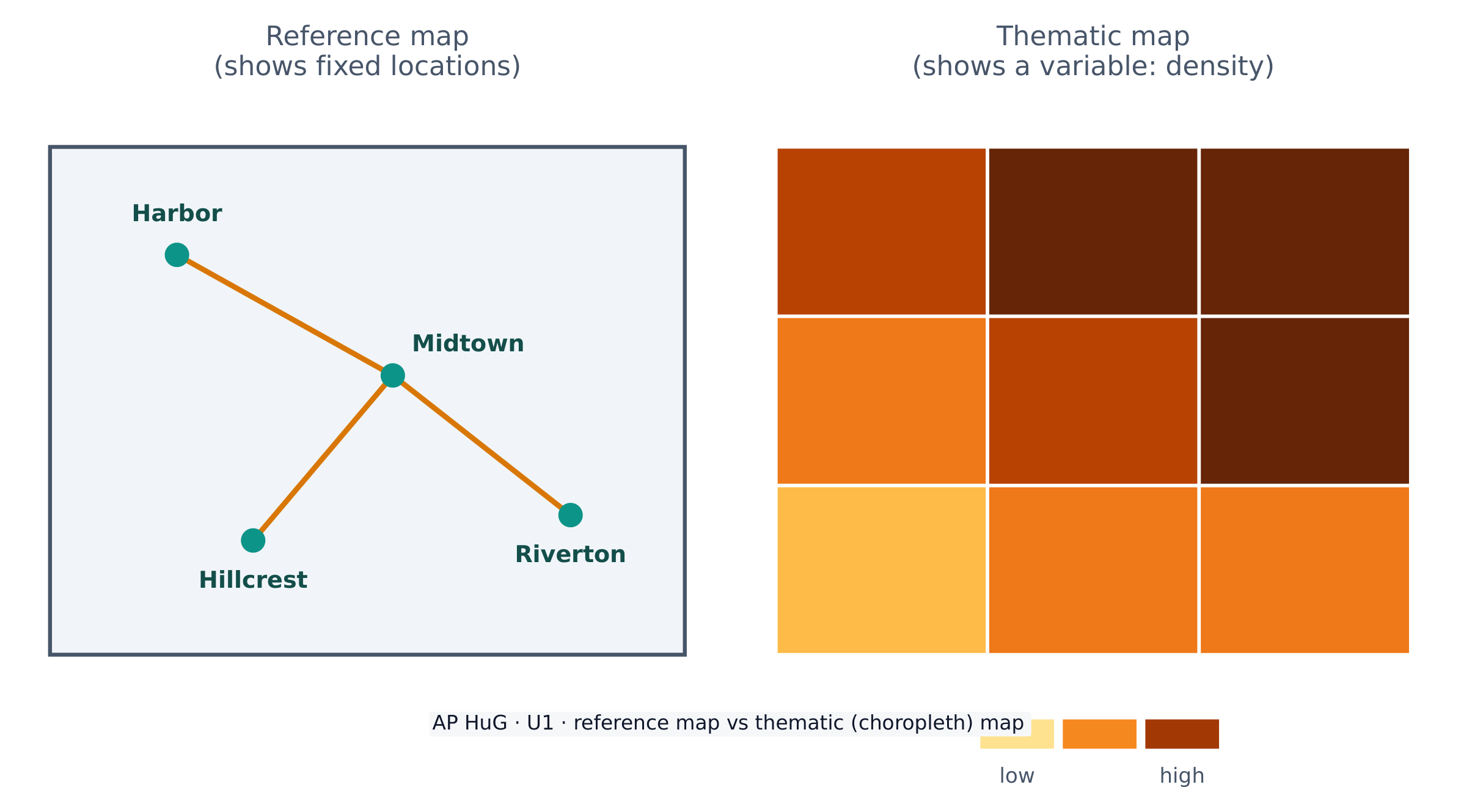
Maps come in two big families. A reference map 参考地图 shows fixed locations — coastlines, borders, roads, cities (a road atlas or Google Maps). A thematic map 专题地图 shows how one variable changes across space — rainfall, income, or population density. AP Human Geography uses thematic maps constantly.

Because Earth is a sphere and a map is flat, every map uses a projection 投影 that stretches the globe onto paper. Projections always distort 扭曲 something — shape, area, distance, or direction. The famous Mercator projection keeps direction correct (useful for sailing) but makes high-latitude places like Greenland look far too large. There is no perfect projection; a cartographer chooses one that fits the map's purpose.

עברית

גיאוגרפיה היא חקר איפה דברים נמצאים ולמה הם שם. הכלי הבסיסי ביותר שלה הוא המפה — תמונה מצולעת של חלק מסוים משטח כדור הארץ.

מפות מגיעות בשתי משפחות גדולות. מפת ייחוס מראה מיקומים קבועים — קווים חוף, גבולות, כבישים, ערים (אטלס כבישים או Google Maps). מפת נושא מראה איך משתנה משתנה אחד במרחב — כמו גשם, הכנסה או צפיפות אוכלוסייה. גיאוגרפיה אנושית AP משתמש במפות נושא באופן מתמיד.

מפות ייחוס מראות מיקום; מפות נושא מראות איך משתנה משתנה במרחב

מכיוון שכדור הארץ הוא כדור ומפה היא שטוחה, כל מפה משתמשת במיפוי (Projection) שממתח את הכדור לעמוד על נייר. מיפויות תמיד מעוותות משהו — צורה, שטח, מרחק או כיוון. המיפוי המפורסם של מרקטור שומר על כיוון נכון (שימושי לנווט ימי) אך גורם למקומות בקו רוחב גבוה כמו גרינלנד להיראות גדולים מדי. אין מיפוי מושלם; קרטוגרף בוחר מיפוי המתאים למטרת המפה.

Vocabulary · ⁨מילון מונחים⁩ Train · ⁨אימון⁩
English עברית
map/mæp/ מפה
reference map/ˈrefrəns mæp/ מפת ייחוס
thematic map/θiːˈmætɪk mæp/ מפת נושא
projection/prəˈdʒekʃn/ מיפוי (הדמה)
distort/dɪˈstɔːt/ מעוותים
Geographic data/ˌdʒɪəˈɡræfɪk ˈdeɪtə/ נתונים גיאוגרפיים
geospatial technologies/ˌdʒiːəʊˈspeɪʃl tekˈnɒlədʒiz/ טכנולוגיות גיאוספציאליות
1.2

Geographic Data · ⁨נתונים גיאוגרפיים⁩

Syllabus · ⁨סיילבוס⁩
English

Enduring Understanding (IMP-1): Geographers use maps and data to depict relationships of time, space, and scale.

Learning Objective IMP-1.B: Identify different methods of geographic data collection.

  • IMP-1.B.1 Data may be gathered in the field by organizations or by individuals.
  • IMP-1.B.2 Geospatial technologies include geographic information systems (GIS), satellite navigation systems, remote sensing, and online mapping and visualization.
  • IMP-1.B.3 Spatial information can come from written accounts in the form of field observations, media reports, travel narratives, policy documents, personal interviews, landscape analysis, and photographic interpretation.
עברית

הבנה מתמשכת (IMP-1): גיאוגרפים משתמשים במפות ובנתונים כדי לתאר קשרים של זמן, מרחב ומידה.

מטרת לימוד IMP-1.B: לזהות שיטות שונות לאיסוף נתונים גיאוגרפיים.

  • IMP-1.B.1 נתונים עשויים להתאספו בשטח על ידי ארגונים או על ידי יחידים.
  • IMP-1.B.2 טכנולוגיות גיאופיזיות כולמערכת מידע גיאוגרפי (GIS), מערכות ניווט לווייני, רחוק-חוש ומיפוי מקוון והצגה ויזואלית.
  • IMP-1.B.3 מידע מרחבי יכול להגיע מחיבורים כתובים בצורת רישום שטח, דוחי תקשורת, סיפורי טיולים, מסמכי מדיניות,ראיונות פרטיים, ניתוח נוף ופרשנות צילום.

Source: College Board AP Course and Exam Description · ⁨מקור: תיאור הקורס והמבחן של College Board AP⁩

English

Geographic data 地理数据 is any information tied to a location. Geographers collect it in the field (counting, surveying, interviewing) and remotely with technology.

Key geospatial technologies 地理空间技术 you must know:

  • GIS 地理信息系统 (Geographic Information System) — software that layers many kinds of spatial data so patterns can be compared.
  • GPS (satellite navigation) — pinpoints exact location on Earth.
  • Remote sensing 遥感 — gathers data from satellites or aircraft without touching the ground.

Data also comes from written sources: field observations, media reports, travel writing, policy documents, interviews, and photographs.

עברית
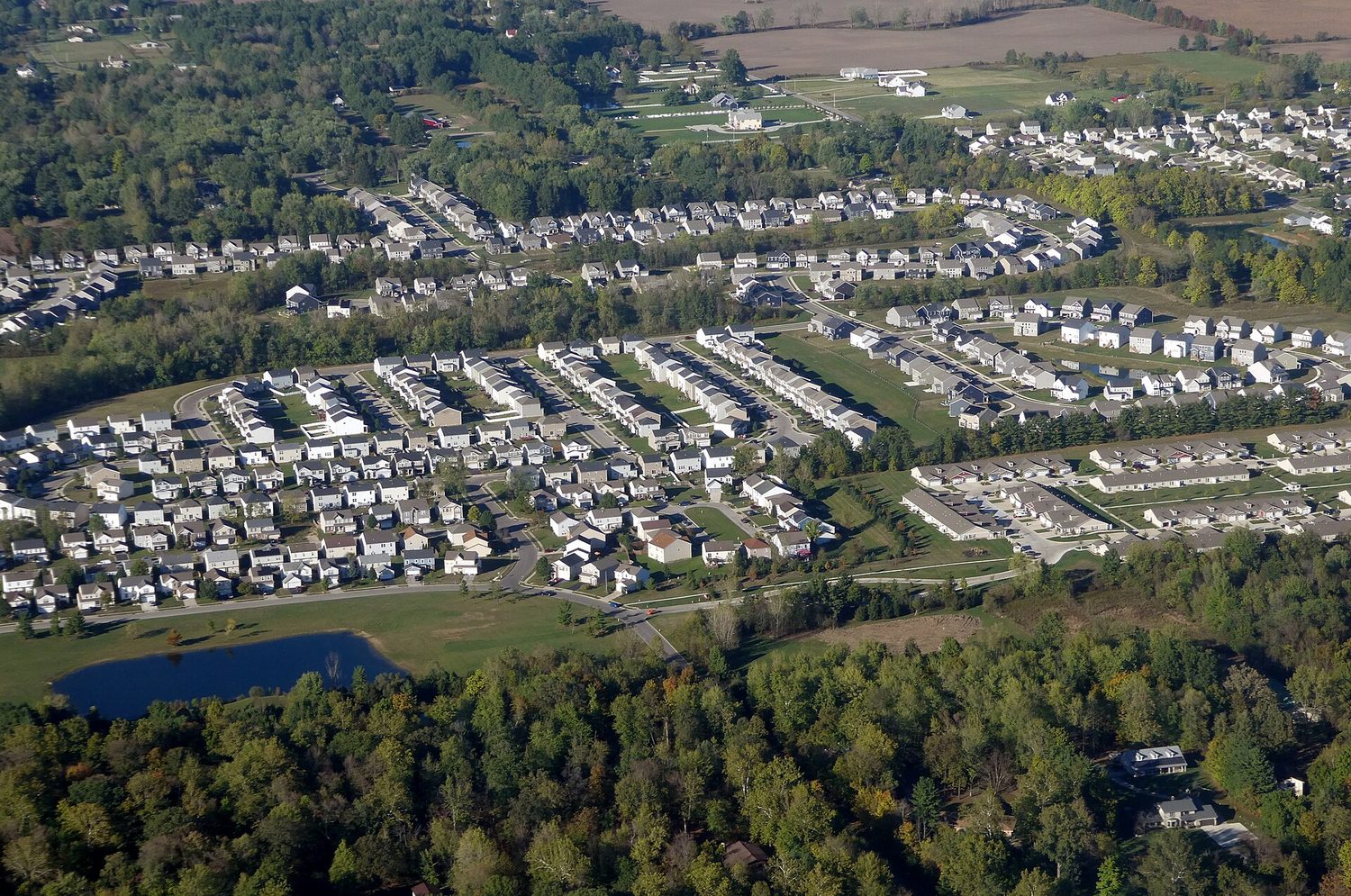
תמונת אופק עירונית צפופה מלמעלה: מפות ונתונים מרחביים מראים איך האוכלוסייה מפוזרת בכדור הארץ

נתונים גיאוגרפיים הם כל מידע הקשור למיקום. גיאוגרפים אוספים אותם בשטח (ספירה, מדידות, ראיונות) ובאופן מרוחק בעזרת טכנולוגיה.

טכנולוגיות מרחביות מפתח שאתה חייב לדעת:

  • GIS (מערכת מידע גיאוגרפי) — תוכנה שמערבת מספר סוגי נתונים מרחביים כדי לאפשר השוואת דפוסים.
  • GPS (ניווט לווייני) — מדויק מיקום מדויק על פני כדור הארץ.
  • הרגשה מרוחקת — אוסף נתונים מלוויינים או מטוסים ללא מגע עם הקרקע.

נתונים מגיעים גם ממקורות כתובים: תצפיות שטח, דיווחי תקשורת, כתיבת נסיעות, מסמכי מדיניות, ראיונות ותמונות.

Vocabulary · ⁨מילון מונחים⁩ Train · ⁨אימון⁩
English עברית
GIS/ˌdʒiː aɪ ˈes/ מערכת מידע גיאוגרפית
Remote sensing/rɪˈməʊt ˈsensɪŋ/ התרשמות ממרחק
Absolute location/ˈæbsəluːt ləʊˈkeɪʃn/ מיקום מוחלט
Relative location/ˈrelətɪv ləʊˈkeɪʃn/ מיקום יחסי
Space–time compression/speɪs taɪm kəmˈpreʃn/ דחיסת זמן-מרחב
1.3

The Power of Geographic Data · ⁨כוחה של מידע גיאוגרפי⁩

Syllabus · ⁨סיילבוס⁩
English

Enduring Understanding (IMP-1): Geographers use maps and data to depict relationships of time, space, and scale.

Learning Objective IMP-1.C: Explain the geographical effects of decisions made using geographical information.

  • IMP-1.C.1 Geospatial and geographical data, including census data and satellite imagery, are used at all scales for personal, business and organizational, and governmental decision- making purposes.
עברית

הבנה מתמשכת (IMP-1): גיאוגרפים משתמשים במפות ובנתונים כדי לתאר קשרים של זמן, מרחב ומידה.

מטרת למידה IMP-1.C: הסבר ההשפעות הגיאוגרפיות של החלטות המבוססות על מידע גיאוגרפי.

  • IMP-1.C.1 נתונים גיאומרחביים וגיאוגרפיים, כולל נתוני מפקד אוכלוסייה ותמונות לווייניות, משמשים בכל קנה מידה לצורך קבלת החלטות אישיות, עסקיות וארגוניות, וכן ממשלתיות.

Source: College Board AP Course and Exam Description · ⁨מקור: תיאור הקורס והמבחן של College Board AP⁩

English

Data is powerful because it drives decisions. Businesses use it to choose store locations, governments use census data to plan schools and roads, and aid agencies use it to send help after a disaster.

But data is never neutral. Who collects it, which categories they use, and how a map is drawn can all shape the message. A map can inform — or it can mislead — so a good geographer always asks where the data came from and what it leaves out.

עברית

מידע חזק משום שהוא מניע חלטות. עסקים משתמשים בו לבחירת מקומות לחנויות, ממשלות משתמשות במידע מפקדי האוכלוסין לתכנון בתי ספר וכבישים, וסוכנויות סיוע משתמשות בו לשליחת עזרה לאחר אסון.

אולם מידע לעולם אינו ניטרלי. מי שאוסף אותו, אילו קטגוריות הוא משתמש בהן, ואיך המפה מצוירת יכולים כולם לעצב את ההודעה. מפה יכולה להעביר מידע — או להטעות — ולכן גיאוגרף טוב תמיד שואל מאיפה הגיע המידע ומה הוא משאיר בחוץ.

1.4

Spatial Concepts · ⁨מושגים מרחביים⁩

Syllabus · ⁨סיילבוס⁩
English

Enduring Understanding (PSO-1): Geographers analyze relationships among and between places to reveal important spatial patterns.

Learning Objective PSO-1.A: Define major geographic concepts that illustrate spatial relationships.

  • PSO-1.A.1 Spatial concepts include absolute and relative location, space, place, flows, distance decay, time-space compression, and pattern.
עברית

הבנה מתמשכת (PSO-1): גיאוגרפיםנתחלקו יחסים בין מקומות ובין מקומות כדי לחשוף תבניות מרחביות חשובות.

מטרת למידה PSO-1.A: הגדרת מושגים גיאוגרפיים עיקריים הממחישים יחסים מרחביים.

  • PSO-1.A.1 מושגים מרחביים כוללים מיקום מוחלט ומיקום יחסי, מרחב, מקום, זרמים, דעיכת מרחק, הדחיסת זמן-מרחב, ותבנית.

Source: College Board AP Course and Exam Description · ⁨מקור: תיאור הקורס והמבחן של College Board AP⁩

English
Distance decay

Geographers describe location and pattern with a precise vocabulary.

  • Absolute location 绝对位置 is an exact address — latitude and longitude. Relative location 相对位置 describes a place by what is near it ("north of the river").
  • Absolute distance is measured in kilometres; relative distance is measured in time, cost, or effort.
  • Space–time compression 时空压缩 is the shrinking of the felt distance between places as transport and communication improve.
  • Distance decay 距离衰减 means that interaction between two places weakens as the distance between them grows.

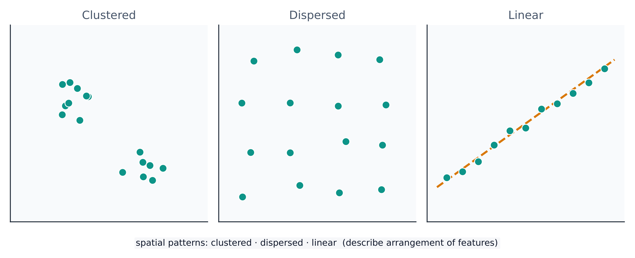
A spatial pattern 空间格局 is how things are arranged: clustered 聚集 (bunched together), dispersed 分散 (spread apart), or linear (along a line such as a road). Reading the pattern is the first step in explaining why it exists.

עברית
דעיכת מרחק

גיאוגרפים מתארים מיקום ותבנית באמצעות אוסף מילים מדויק.

  • מיקום מוחלט הוא כתובת מדויקת — רוחב ואורך גיאוגרפיים. מיקום יחסי מתאר מקום על פי מה שמסביבו ("צפונית לנהר").
  • מרחק מוחלט נמדד בקילומטרים; מרחק יחסי נמדד בזמן, בעלות או במאמץ.
  • דחיסת מרחב-זמן היא הצטמצמות התחושה של המרחק בין מקומות כאשר התחבורה והתקשורת משתפרות.
  • דעיכת מרחק פירושה שהאינטראקציה בין שני מקומות מתחלשת ככל שהמרחק ביניהם גדל.
נקודות על הקרקע יכולות להיות צמודות, מפוזרות או מסודרות לאורך קו
נקודות יכולות להיות צמודות, מפוזרות או מסודרות לאורך קו — התבנית המרחבית עצמה מהווה מידע

תבנית מרחבית היא האופן שבו דברים מסודרים: צמודות (קבוצות יחד), פיזור (מוקרנים זה מזה) או קווי (לאורך קו כמו כביש). קריאת התבנית היא השלב הראשון בהסבר למה היא קיימת.

Vocabulary · ⁨מילון מונחים⁩ Train · ⁨אימון⁩
English עברית
Distance decay/ˈdɪstəns dɪˈkeɪ/ ירידת עוצמה עם המרחק
spatial pattern/ˈspeɪʃl ˈpætn/ תבנית מרחבית
clustered/ˈklʌstəd/ צמודה/ערום
dispersed/dɪˈspɜːst/ מפוזרת
Environmental determinism/enˌvaɪrənˈmentl dɪˈtɜːmɪnɪzəm/ גודרמיניזם סביבתי
Possibilism/ˈpɒsɪbɪlɪzəm/ אפשרנות
cultural landscape/ˈkʌltʃərəl ˈlændskeɪp/ נוף תרבותי
Scale of analysis/skeɪl ɒv əˈnæləsɪs/ סקאלה של ניתוח
region/ˈriːdʒn/ אזור
Formal (uniform) region/ˈfɔːml ˈriːdʒn/ אזור פורמלי (אחיד)
Functional (nodal) region/ˈfʌŋkʃənl ˈriːdʒn/ אזור פונקציונלי (נקודי)
Perceptual (vernacular) region/pəˈseptʃuːəl ˈriːdʒn/ אזור תפיסתי (עממי)
Watch lesson · ⁨צפה בשיעור⁩
1.5

Human-Environmental Interaction · ⁨אינטראקציה אנושית-סביבתית⁩

Syllabus · ⁨סיילבוס⁩
English

Enduring Understanding (PSO-1): Geographers analyze relationships among and between places to reveal important spatial patterns.

Learning Objective PSO-1.B: Explain how major geographic concepts illustrate spatial relationships.

  • PSO-1.B.1 Concepts of nature and society include sustainability, natural resources, and land use.
  • PSO-1.B.2 Theories regarding the interaction of the natural environment with human societies have evolved from environmental determinism to possibilism.
עברית

הבנה מתמשכת (PSO-1): גיאוגרפיםנתחלקו יחסים בין מקומות ובין מקומות כדי לחשוף תבניות מרחביות חשובות.

מטרת למידה PSO-1.B: הסבר כיצד מושגים גיאוגרפיים עיקריים ממחישים יחסים מרחביים.

  • PSO-1.B.1 מושגי טבע וחברה כוללים קיימות, משאבים טבעיים, והשתמשי אדמה.
  • PSO-1.B.2 תיאוריות בנוגע לאינטראקציה בין הסביבה הטבעית לבין חברה אנושית התפתחו מהדיטרמיניזם הסביבתי לפסיביליזם.

Source: College Board AP Course and Exam Description · ⁨מקור: תיאור הקורס והמבחן של College Board AP⁩

English

People and the environment shape each other. Three older ideas describe this:

  • Environmental determinism 环境决定论 — the (now rejected) claim that the physical environment determines how a culture develops.
  • Possibilism 可能论 — the accepted view that the environment sets limits, but people choose how to respond using technology and culture.

The cultural landscape 文化景观 — farms, cities, and roads built on the land — is the visible result of this interaction. Sustainability asks how people can use natural resources without using them up.

עברית
התפשטות עירונית בשפת העיר: אינטראקציה אנושית-סביבתית מעצבת נופים

אנשים וסביבה מעצבים זה את זה. שלושה רעיונות ישנים מתארים זאת:

  • קביעת סביבתית — הטענה (שהופרכה כיום) לפיה הסביבה הפיזית קובעת כיצד תרבות מתפתחת.
  • אפשרנות — הדעה המקובלת לפיה הסביבה קובעת גבולות, אך אנשים בוחרים כיצד להגיב באמצעות טכנולוגיה ותרבות.

הנוף התרבותי — חוות חקלאיות, ערים וכבישים שנבנו על הקרקע — הוא התוצאה הנראית של אינטראקציה זו. קיימות שואלת כיצד אנשים יכולים להשתמש במשאבים טבעיים מבלי לערער אותם.

1.6

Scales of Analysis · ⁨רמות ניתוח⁩

Syllabus · ⁨סיילבוס⁩
English

Enduring Understanding (PSO-1): Geographers analyze relationships among and between places to reveal important spatial patterns.

Learning Objective PSO-1.C: Define scales of analysis used by geographers.

  • PSO-1.C.1 Scales of analysis include global, regional, national, and local.

Learning Objective PSO-1.D: Explain what scales of analysis reveal.

  • PSO-1.D.1 Patterns and processes at different scales reveal variations in, and different interpretations of, data.
עברית

הבנה מתמשכת (PSO-1): גיאוגרפיםנתחלקו יחסים בין מקומות ובין מקומות כדי לחשוף תבניות מרחביות חשובות.

מטרת למידה PSO-1.C: הגדרת קני מידה של ניתוח המשמשים גיאוגרפים.

  • PSO-1.C.1 קני מידה של ניתוח כוללים גלובלי, אזורי, לאומי ולוקאלי.

מטרת למידה PSO-1.D: הסבר מה שקני המידה של הניתוח חושפים.

  • PSO-1.D.1 תבניות ותהליכים בקני מידה שונים חושפים הבדלים ופרשנויות שונות של נתונים.

Source: College Board AP Course and Exam Description · ⁨מקור: תיאור הקורס והמבחן של College Board AP⁩

English

Scale of analysis 分析尺度 is the level at which you look at data — global, regional, national, or local. The same pattern can look completely different at different scales.

For example, a country may look wealthy at the national scale, yet contain very poor neighbourhoods at the local scale. Zooming in or out — changing the scale — reveals patterns that were hidden before. Exam questions often ask you to explain a process "at various scales."

Worked example (a real AP exam question). "The map focuses on a regional scale. Explain a possible limitation of drawing country-scale conclusions from a regional-scale map." (2025) A full-mark answer: "The map shows only one region, so its pattern may not represent the whole country — other regions could look very different, so a conclusion drawn at the regional scale would be inaccurate at the country scale." The command word Explain asks for reasoning: state the limitation and say why changing the scale changes the pattern. Just writing "the scales are different" does not earn the mark.

עברית

רמת הניתוח היא הרמה בה אתה בודק נתונים — גלובלית, אזורית, לאומית או מקומית. אותו דפוס יכול להיראות שונה לחלוטין ברמות שונות.

דפוס המסתנן בין רמות: גלובלית, אזורית, לאומית ומקומית
אותו מקום מסתנן לתוך רמות גדולות越来越 — הרמה שתבחר משנה את הדפוס שאתה רואה

לדוגמה, מדינה עשויה להיראות עשירה ברמה הלאומית, אך להכיל שכונות עניות מאוד ברמה המקומית. הזום פנימה או החוצה — שינוי הרמה — חושף דפוסים שהיו נסתרים לפני כן. שאלות במבחנים נהוג לבקש מהך להסביר תהליך "ברמות שונות".

דוגמא מפורטת (שאלה אמיתית במבחן AP). "המפה מתמקדת ברמה אזורית. הסבר הגבלה אפשרית במציאת מסקנות ברמה לאומית מתוך מפה ברמה אזורית." (2025) תשובה מלאה בנקודות: "המפה מראה אזור אחד בלבד, ולכן הדפוס שלה עשוי לא לייצג את כל המדינה — אזורים אחרים עשויים להיראות שונים מאוד, ולכן מסקנה שהופקה ברמה האזורית תהיה לא מדויקת ברמה הלאומית." המילה המנחה הסבר דורשת נימוקים: יש לציין את ההגבלה וגם להסביר מדוע שינוי הרמה משנה את הדפוס. כתיבה פשוטה של "הרמות שונות" אינה מעניקה נקודה.

1.7

Regional Analysis · ⁨ניתוח אזורי⁩

Syllabus · ⁨סיילבוס⁩
English

Enduring Understanding (SPS-1): Geographers analyze complex issues and relationships with a distinctively spatial perspective.

Learning Objective SPS-1.A: Describe different ways that geographers define regions.

  • SPS-1.A.1 Regions are defined on the basis of one or more unifying characteristics or on patterns of activity.
  • SPS-1.A.2 Types of regions include formal, functional, and perceptual/vernacular.
  • SPS-1.A.3 Regional boundaries are transitional and often contested and overlapping.
  • SPS-1.A.4 Geographers apply regional analysis at local, national, and global scales.
עברית

הבנה מתמשכת (SPS-1): גיאוגרפיםנתחלקו נושאים מורכבים ויחסים עם פרספקטיבה מרחבית ייחודית.

מטרת למידה SPS-1.A: תיאור דרכים שונות שבהן גיאוגרפים מגדירים אזורים.

  • SPS-1.A.1 אזורים מוגדרים על בסיס מאפיין אחד או יותר מאחדים או על בסיס תבניות פעילות.
  • SPS-1.A.2 סוגי אזורים כוללים פורמלי, פונקציונלי ופרספציונלי/עממי.
  • SPS-1.A.3 גבולות אזוריים הם מעבר ורבים מהם מחלוקת או חופפים זה על גבי זה.
  • SPS-1.A.4 גיאוגרפאים משמשים ניתוח אזורי בקנה מידה מקומי, לאומי וגלובלי.

Source: College Board AP Course and Exam Description · ⁨מקור: תיאור הקורס והמבחן של College Board AP⁩

English

A region 区域 is an area with one or more shared features that make it different from surrounding areas. Geographers use three types:

  • Formal (uniform) region 均质区域 — everyone shares a measurable trait (a country, a wheat-growing belt, a language area).
  • Functional (nodal) region 功能区域 — organised around a central node, like a city and its commuter zone or a pizza shop's delivery area.
  • Perceptual (vernacular) region 感知区域 — defined by people's feelings and beliefs, with fuzzy borders (the "American South", the "Middle East").

Regions are made by geographers, not found in nature — so their borders can be argued about, which is exactly why they are useful for analysis.

עברית

אזור הוא אזור בעל מאפיין אחד או יותר משותפים שמבדילים אותו מאזורים הסובבים אותו. גיאוגרפים משתמשים בשלושה סוגים:

  • אזור פורמלי (אחיד) — כולםparticipate in a measurable trait (a country, a wheat-growing belt, a language area).
  • אזור פונקציונלי (נודיאלי) — מאורגן סביב נקודת מרכז (node), כמו עיר ואזור המטיינים שלה או אזור המשלוחים של חנות פיצה.
  • אזור תפיסתי (אוכלוסייתי/פרובינציאלי) — מוגדר על ידי תחושות ואמונות של אנשים, עם גבולות מטושטשים (ה"דרום האמריקאי", ה"מזרח התיכון").

אזורים נוצרים על ידי גיאוגרפים, ולא נמצאים בטבע — ולכן הגבולות שלהם יכולים להיות מחלוקת, וזה בדיוק למה שהם מועילים לניתוח.

Explore · ⁨חקור⁩

Sort each example into the right kind of region · ⁨סווג כל דוגמה לסוג האזור הנכון⁩

A formal region shares one measured trait, a functional region is organised around a node, and a perceptual region is defined by people's feelings. · ⁨אזור רשמי משותף מאפיין נמדד אחד, אזור פונקציונלי מאורגן סביב נקודה מרכזית, ואזור תפיסתי מוגדר על ידי תחושות אנשים.⁩

1.7

Exam tips · ⁨טיפים לבחינות⁩

English
  • Always name a map projection's trade-off: what it preserves versus distorts (Mercator keeps direction but exaggerates area).
  • State whether data is quantitative or qualitative, and match a source (GIS, GPS, remote sensing, census) to its use.
  • Distinguish absolute from relative location, and use distance decay and time-space compression in any flow answer.
  • Mind the scale of analysis: a national average hides local variation — say so explicitly.
  • Classify every region as formal, functional, or perceptual, and justify it by the defining trait.
עברית
  • תמיד ציין את הפיצול במיפוי: מה שהוא שומר עליו מול מה שהוא מעוות (מרקטור שומר כיוון אך מגדיל שטח).
  • ציין אם הנתונים הם כמותיים או איכותיים, והתאם מקור (GIS, GPS, מיפוי מרחוק, מפקד אוכלוסין) לשימוש שלו.
  • הבדל בין מיקום מוחלט לבין מיקום יחסי, והשתמש בדעיכת מרחק ובדחיסת זמן-מרחב בכל תשובה העוסקת בזרימות.
  • שימו לב לרמת הניתוח: ממוצע לאומי מכסה הבדלים מקומיים — ציין זאת במפורש.
  • סווג כל אזור כפורמלי, פונקציונלי או תפיסתי, והצדק זאת לפי המאפיין המגדיר.

Interactive lessons on this topic · ⁨שיעורים אינטראקטיביים בנושא זה⁩

Work through it step by step, with instant-check exercises. · ⁨לעבור על הדברים צעד אחר צעד, עם תרגילים לבדיקה מיידית.⁩

Past Papers · ⁨מבחני עבר⁩

More topics in AP Human Geography · ⁨גיאוגרפיה אנושית - AP⁩ · ⁨נושאים נוספים בAP Human Geography · ⁨גיאוגרפיה אנושית - AP⁩⁩

Log in or create account · ⁨היכנס או צור חשבון⁩

IGCSE, A-Level & AP