The Internal Structure of Cities
Introduzido| English | Significado |
|---|---|
| Central Business District/ˈsentrəl ˈbɪznəs ˈdɪstrɪkt/ | Distrito Central de Negócios |
| concentric zone model/kənˈsentrɪk zəʊn ˈmɒdl/ | Modelo de Zonas Concêntricas |
| sector model/ˈsektə ˈmɒdl/ | Modelo Setorial |
| multiple nuclei model/ˈmʌltɪpl ˈnjuːklɪi ˈmɒdl/ | Modelo de Núcleos Múltiplos |
Why are skyscrapers in the middle?
- In most cities, the tallest buildings stand in the centre, where land is most expensive, and houses with gardens spread outward where land is cheaper. Shops and offices can pay the most for central land because that is where the most customers and workers can reach them.
- This is bid-rent theory: each land use bids for each location, and the highest bidder wins. Geographers built several models of city structure on this idea, starting from the Central Business District 中央商务区 (CBD).
According to bid-rent theory, why are offices and shops usually in the CBD?
Dificuldade 1/5 · Moedas 100 + pequeno bônus na primeira conclusão hoje
The most accessible land goes to the uses that earn most from accessibility.
Three North American models
| Model | Shape | Key idea | Based on |
|---|---|---|---|
| Concentric zone model 同心圆模型 (Burgess, 1925) | rings around the CBD | the city grows outward; wealthier people live further out | Chicago |
| Sector model 扇形模型 (Hoyt, 1939) | wedges from the CBD | land uses grow along transport routes; a high-income wedge follows the best routes and views | many US cities |
| Multiple nuclei model 多核心模型 (Harris and Ullman, 1945) | several centres | the car allows new nodes (an airport, a university, a port) each with its own cluster | large car-based cities |
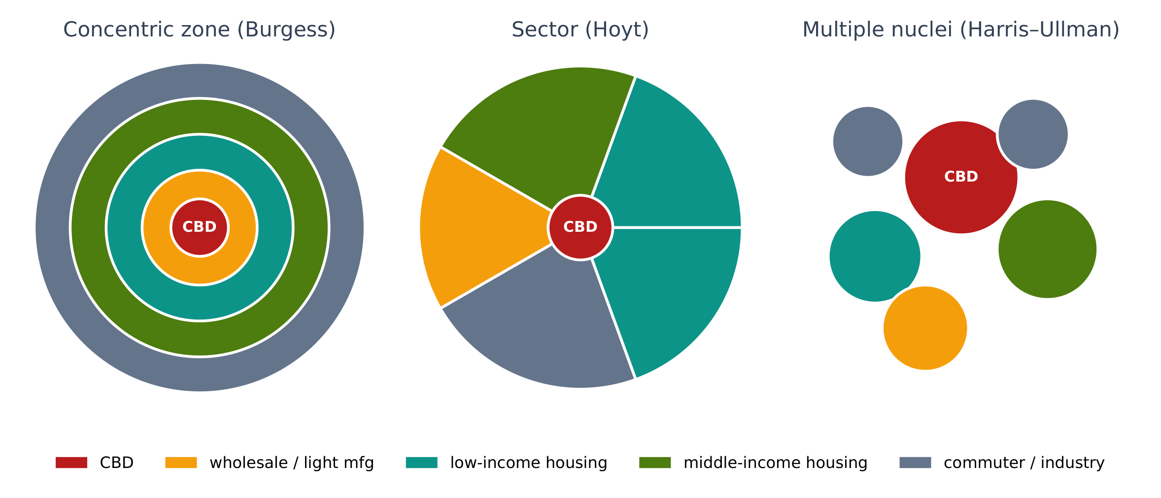
Which urban model?
Sort each description by its urban model.
Match each model to its shape.
Dificuldade 2/5 · Moedas 140 + pequeno bônus na primeira conclusão hoje
Rings, wedges, nodes.
High-income housing forms a wedge along a rail line from the centre to the edge. Which model fits?
Dificuldade 1/5 · Moedas 100 + pequeno bônus na primeira conclusão hoje
Hoyt's sectors grow along transport routes.
The galactic city (edge city) model
- After the 1950s, highways and cars let shopping centres, offices and housing spread far from the old CBD. The galactic city model shows a declining central city surrounded by suburbs and edge cities: clusters of offices and malls near highway junctions, such as Tysons outside Washington, D.C.
- The CBD is no longer the only centre; ring roads connect many nodes.
Edge cities are clusters of offices and malls near highway junctions far from the old CBD.
Dificuldade 1/5 · Moedas 100 + pequeno bônus na primeira conclusão hoje
They are a key feature of the galactic city model.
Models for cities outside North America
| Model | Key features |
|---|---|
| Latin American (Griffin–Ford) | a CBD with a spine of wealthy housing and businesses along a main boulevard; wealth falls with distance; poor informal settlements (favelas, barrios) on the edge |
| African (de Blij) | three CBDs (colonial, traditional, market); ethnic neighbourhoods; informal settlements on the outskirts |
| Southeast Asian (McGee) | the old colonial port is the focus, not a CBD; commercial zones, Western-style and alien (Chinese) commercial areas; farming mixed into the outer zones |
- A key contrast: in North America the rich often live in the suburbs; in Latin American and African cities the poorest often live on the edge.
Match each feature to its city model.
Dificuldade 2/5 · Moedas 140 + pequeno bônus na primeira conclusão hoje
Each model reflects its region's history.
Worked FRQ answer
(A) Identify the urban model in which wealthy housing extends outward from the CBD along a main boulevard. The Latin American city model (Griffin–Ford), with its spine.
(B) Explain ONE reason poor informal settlements develop on the edge of many Latin American cities. Rural migrants arrive faster than formal housing can be built, and they cannot afford central land, so they build homes on unused land at the edge, often without services such as water and sewers.
(C) Explain ONE way the multiple nuclei model differs from the concentric zone model. The concentric zone model has one centre with rings of land use growing outward, while the multiple nuclei model has several separate centres, such as an airport district or university area, each attracting its own related activities.
- Why it scores: names the model precisely, explains a process (migration and land cost), and compares the structure of two models, not just their names.
Models simplify reality. No real city matches one model exactly. In an FRQ, explain which features of a city fit a model and which do not.
Bid-rent puts the highest-paying uses in the CBD. North American models: concentric zone (rings), sector (wedges along routes), multiple nuclei (several centres), and the galactic city (edge cities along highways). Other regions: Latin American (spine, edge favelas), African (three CBDs) and Southeast Asian (port-centred) models.
FRQ practice. (A) Describe where the wealthiest residents live in the concentric zone model. (B) Explain why this differs from the Latin American city model. (C) Explain ONE limitation of using the concentric zone model today.
Compare structures and explain the processes behind them.