Settlement Patterns and Survey Methods
Introduzido| English | Significado |
|---|---|
| settlement patterns/ˈsetəlmənt ˈpætnz/ | padrões de assentamento |
| clustered/ˈklʌstəd/ | agrupado |
| dispersed/dɪˈspɜːst/ | disperso |
| metes-and-bounds/miːts ænd baʊndz/ | descritivo de limites |
| township-and-range/ˈtaʊnʃɪp ænd reɪndʒ/ | sistema quadriculado |
| long-lot/lɒŋ lɒt/ | lote longo |
Squares from the sky
- Fly over Iowa or Kansas and the land below is a giant chequerboard: roads run exactly north-south and east-west, one mile apart. Fly over Québec and farms are long, thin strips running back from the St Lawrence River. Fly over New England or Kentucky and field edges wander along streams and hills.
- These patterns come from survey methods (how land was measured and divided) and settlement patterns 聚落格局 (how homes are arranged). Both last for centuries in the landscape.
Rural settlement patterns
| Pattern | Arrangement | Why | Example |
|---|---|---|---|
| Clustered 聚集 (nucleated) | homes grouped in a village, fields around it | shared water, defence, community | farming villages in China and Europe |
| Dispersed 分散 | farmhouses spread out, each on its own land | large farms; land given in big blocks | the US Great Plains |
| Linear | homes in a line along a road, river or coast | access to transport or water | villages along the Rhine; French long-lot settlements |
Match each settlement to its pattern.
Dificuldade 2/5 · Moedas 140 + pequeno bônus na primeira conclusão hoje
Grouped, spread out, or in a line.
Three survey methods
| Method | How land is divided | Landscape | Where |
|---|---|---|---|
| Metes-and-bounds 地界描述法 | by natural features and distances ("from the oak tree to the creek") | irregular field shapes | original 13 US colonies; England |
| Township-and-range 方格测量制 | a grid of 6-mile-square townships, divided into 1-mile sections | straight roads, square fields | most of the US west of Ohio (from the Land Ordinance of 1785) |
| Long-lot 长条田 | narrow strips running back from a river or road | thin parallel fields, homes in a line along the front | Québec, Louisiana (French settlement) |
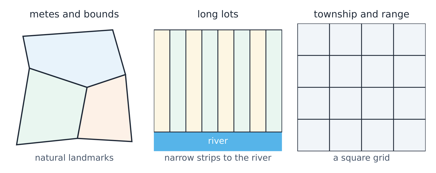
Qual método de levantamento?
Sort each description by its survey method.
Match each survey method to its landscape.
Dificuldade 2/5 · Moedas 140 + pequeno bônus na primeira conclusão hoje
Each method leaves a distinctive pattern.
Where is the long-lot system most associated with?
Dificuldade 1/5 · Moedas 100 + pequeno bônus na primeira conclusão hoje
French settlers divided land into strips along rivers.
Why the method mattered
- Long-lot gave every family river access for water and transport, so homes lined up along the river (a linear pattern).
- Township-and-range made land easy to sell and record in a new country; families lived on their own square farms, creating a dispersed pattern and a grid of roads still used today.
Township-and-range encouraged a dispersed settlement pattern.
Dificuldade 1/5 · Moedas 100 + pequeno bônus na primeira conclusão hoje
Families lived on their own large square farms.
Worked FRQ answer
(A) Identify the survey method that produced square fields and a grid of roads in the US Midwest. The township-and-range system.
(B) Explain why the long-lot system was used in French settlements along rivers. Rivers were the main transport routes and water sources, so dividing land into narrow strips gave every farm a river frontage.
(C) Explain how township-and-range affected rural settlement patterns. Land was sold in large square sections and families built homes on their own land, so farmhouses were spread out in a dispersed pattern rather than grouped in villages.
- Why it scores: each part links a method to its reason or its visible result in the landscape.
Survey method and settlement pattern are different things. The survey method divides the land; the settlement pattern describes where the homes are. One often causes the other.
Rural settlement patterns are clustered, dispersed or linear. Survey methods divide land: metes-and-bounds (natural features, irregular), township-and-range (grid of squares, US Midwest) and long-lot (narrow strips from a river, French settlement). Survey methods shape roads, fields and settlement for centuries.
FRQ practice. A map shows straight roads crossing at right angles every mile, with single farmhouses spread across the land. (A) Identify the survey method. (B) Identify the settlement pattern. (C) Explain ONE advantage of this survey method for a new government.
Read the landscape back to its cause.